File:Deer stone with equids.jpg
Aller à la navigation
Aller à la recherche

Taille de cet aperçu : 800 × 533 pixels. Autres résolutions : 320 × 213 pixels | 640 × 427 pixels | 1 024 × 683 pixels | 1 280 × 853 pixels | 2 560 × 1 707 pixels | 5 184 × 3 456 pixels.
Fichier d’origine (5 184 × 3 456 pixels, taille du fichier : 12,25 Mio, type MIME : image/jpeg)
Légendes
Légendes
Ajoutez en une ligne la description de ce que représente ce fichier
Deer stone with equids
Description
[modifier]
| Description |
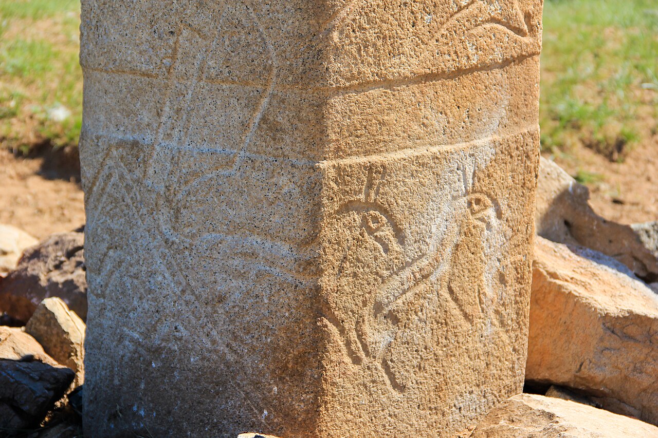
English: South-West Corner showing axe, bow, quiver and equids, of Very large Orange Granite Deerstone Reerected by the Monaco Mission, surrounded by dozens of stone circles containing horse-head offerings. The largest deerstone in the Tamir Valley. The Deerstone includes equids (horses or onagers as well as the usual reindeer). From bottom to top: On the west face, two equids walking right, an axe, a bow and quiver, and the rear half of a larger equid walking right. The bow and quiver cross the belt. On the south face, the front half of the equid from the west face and two equids flying to the upper right with legs extended. Six very large reindeer flying horizontally to the right, legs extended. These large reindeer wrap completely around the deerstone. The topmost reindeer has three-toed bird-claw feet as on the large deerstone at Shivert south of the Tamir, clearly indicating the bird-reindeers' magic nature. A line of dots. At the top of the west face, a sun with a moon to the upper left. It is also somewhat unusual in being near the center of a dry side valley branching off the Tamir. Most deerstones are near streams or rivers. However, the Bronze-Age landscape was wetter than todays, so the valley may well have had a stream at the time the deerstone was erected. Alternatively, the site may have been chosen simply because it is visible from several miles away in every direction. Tsatsyn Denj Deerstones on the bluffs North of the Tamir River in association with many later monuments. Many of the deerstones were reused as walls in Square tombs. Recent excavations by the Monaco mission under the direction of Jerome Magail have reerected many of these and we were able to see 43 in the area (two have been moved to Ulaan Baatar) Originally, the valley must have been lined with hundreds of deerstones with several on every point in the bluffs. While the exact meaning of deerstones is still debated, they are clearly totemic markers with shamanic content, symbolizing simultaneously a stylized human form, the sacred cosmos and the fertilizing phallus. The Forest God in the Japanese Manga film "Princess Mononoke" give a good idea of what the deerstone represent. They are not grave markers, though some are associated with (later?/contemporary?) Khirig Sur (kurgan) burials. Almost all have highly stylized bird-reindeer with open beaks and baroque horns, flying between earth and heaven, which also represent tattoos or embroidery, a belt which also represents the earth, suns that double as ears, a line of dots that demarcate both the heavens and the glans of the penis, and an enigmatic sporran--which may be a shield or shamanic cloak or bag. Weapons (sword, bow--sometimes drawn, with arrow--, quiver or bow case, axe, dagger) are also common. Most deerstones were erected on South-facing bluffs overlooking rivers, as here over the Tamir, where they would be both visible and in position to influence the fertility of the valley. Today, each family has its deerstone or group of deerstones, which they usually protect (though one family was using theirs as the roof of a dog house). Bronze Age (recently dates have crept earlier to roughly 1300 BC - 700 BC). When I first came to Mongolia in the 1990s, deerstones were considered rare. That situation has since changed radically. The later builders of Square Tombs loved deerstones for their sacred power and would drag them a long way to use as the walls and covers of their tombs (as many as 11 deerstones per tomb). As a result, now that Square Tombs are being excavated regularly, more than 700 deerstones are known. I'd estimate at least 2000 deertsones survive in Mongolia in Square Tombs. This large number indicates that they may hae been clan specific and that they were erected at fairly frequent intervals (e.g. after an eclipse or on the death of a ruler). Tsatsyn Denj, Tamir River Valley, Battsengel Sum, Arkhangai Aimag, Mongolia. |
| Date | |
| Source | https://www.flickr.com/photos/jag_jaf_travel/6010837464/ |
| Auteur | James Glazier |
| Lieu de la prise de vue | | Voir cet endroit et d’autres images sur : OpenStreetMap |
|---|
Conditions d’utilisation
[modifier]
Ce fichier est disponible selon les termes de la licence Creative Commons Attribution – Partage dans les Mêmes Conditions 2.0 Générique
- Vous êtes libre :
- de partager – de copier, distribuer et transmettre cette œuvre
- d’adapter – de modifier cette œuvre
- Sous les conditions suivantes :
- paternité – Vous devez donner les informations appropriées concernant l'auteur, fournir un lien vers la licence et indiquer si des modifications ont été faites. Vous pouvez faire cela par tout moyen raisonnable, mais en aucune façon suggérant que l’auteur vous soutient ou approuve l’utilisation que vous en faites.
- partage à l’identique – Si vous modifiez, transformez, ou vous basez sur cette œuvre, vous devez distribuer votre contribution sous la même licence ou une licence compatible avec celle de l’original.
| Cette image a été originellement postée sur Flickr par jaglazier à l'adresse https://flickr.com/photos/22937552@N07/6010837464. Elle a été passée en revue le 14 novembre 2023 par le robot FlickreviewR 2, qui a confirmé qu'elle se trouvait sous licence cc-by-sa-2.0. |
Historique du fichier
Cliquer sur une date et heure pour voir le fichier tel qu'il était à ce moment-là.
| Date et heure | Vignette | Dimensions | Utilisateur | Commentaire | |
|---|---|---|---|---|---|
| actuel | 14 novembre 2023 à 06:04 | | 5 184 × 3 456 (12,25 Mio) | पाटलिपुत्र (d | contributions) | Uploaded a work by James Glazier from https://www.flickr.com/photos/jag_jaf_travel/6010837464/ with UploadWizard |
Vous ne pouvez pas remplacer ce fichier.
Utilisations locales du fichier
Aucune page n’utilise ce fichier.
Utilisations du fichier sur d’autres wikis
Les autres wikis suivants utilisent ce fichier :
- Utilisation sur fr.wikipedia.org