File:Dena1.jpg
Naviqasiyaya keç
Axtarışa keç
Sınaq göstərişi ölçüsü: 800 × 444 piksel. Digər ölçülər: 320 × 178 piksel | 640 × 355 piksel | 1.200 × 666 piksel.
Faylın orijinalı (1.200 × 666 piksel, fayl həcmi: 263 KB, MIME növü: image/jpeg)
Captions
Captions
Add a one-line explanation of what this file represents
Xülasə[redaktə]
| İzah |
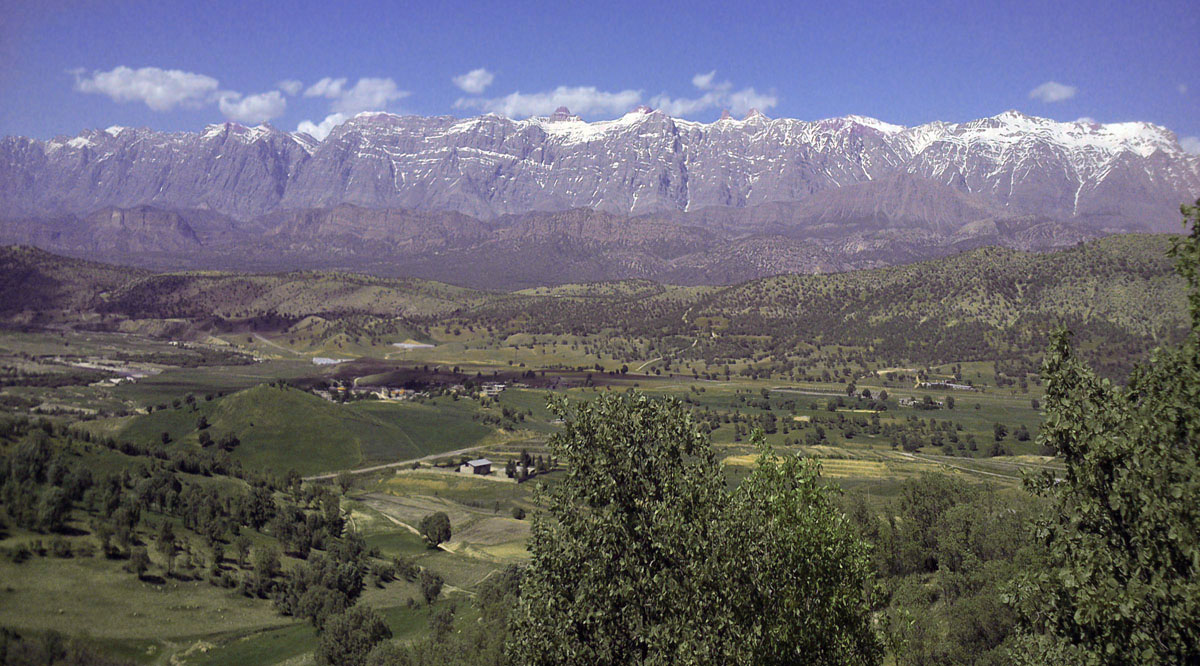
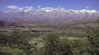
English: Dena mountain |
| Tarix | |
| Mənbə | Öz işi |
| Müəllif | Vah.hem |
| Camera location | | View this and other nearby images on: OpenStreetMap |
|---|
Lisenziya[redaktə]
I, the copyright holder of this work, hereby publish it under the following license:
Bu fayl Creative Commons Attribution-Share Alike 3.0 Unported lisenziyası altında yayımlanır.
- Azadsınız:
- paylaşmaq – əsəri köçürmək, paylamaq və ötürmək üçün
- remiks etmək – əsəri adaptasiya etmək
- Aşağıdakı şərtlərə riayət etməklə:
- istinad – Müvafiq kredit verməlisiniz, lisenziyaya bir keçid verməlisiniz və dəyişikliklərin olub olmadığını bildirməlisiniz. Bunu hər hansı bir ağlabatan şəkildə edə bilərsiniz, ancaq lisenziyalaşdırıcının sizi və ya istifadənizi təsdiqləməsini təklif edən bir şəkildə deyil.
- bənzər paylaşma – Əsəri remix edirsinizsə, dəyişdirirsinizsə və ya üzərində iş aparırsınızsa, öz töhfələrinizi orijinalda olduğu kimi eyni və ya uyğun lisenziya altında yayımlamalısınız.
Faylın tarixçəsi
Faylın əvvəlki versiyasını görmək üçün gün/tarix bölməsindəki tarixlərə klikləyin.
| Tarix/Vaxt | Kiçik şəkil | Ölçülər | İstifadəçi | Şərh | |
|---|---|---|---|---|---|
| indiki | 07:33, 5 fevral 2014 | | 1.200 × 666 (263 KB) | Vah.hem (müzakirə | töhfələr) | User created page with UploadWizard |
Siz bu faylı yenidən yükləyə bilməzsiniz.
Fayl keçidləri
Aşağıdakı 70 səhifə bu faylı istifadə edir:
- Category:Agriculture in Kohgiluyeh and Boyer-Ahmad Province
- Category:Air transport in Kohgiluyeh and Boyer-Ahmad Province
- Category:Air transport infrastructure in Kohgiluyeh and Boyer-Ahmad Province
- Category:Airports in Kohgiluyeh and Boyer-Ahmad Province
- Category:Animals of Kohgiluyeh and Boyer-Ahmad Province
- Category:Architecture of Kohgiluyeh and Boyer-Ahmad Province
- Category:Art of Kohgiluyeh and Boyer-Ahmad Province
- Category:Birds of Kohgiluyeh and Boyer-Ahmad Province
- Category:Bodies of water in Kohgiluyeh and Boyer-Ahmad Province
- Category:Bridges in Kohgiluyeh and Boyer-Ahmad Province
- Category:Buildings in Kohgiluyeh and Boyer-Ahmad Province
- Category:Castles in Kohgiluyeh and Boyer-Ahmad Province
- Category:Cities in Kohgiluyeh and Boyer-Ahmad Province
- Category:Clouds in Kohgiluyeh and Boyer-Ahmad Province
- Category:Counties of Kohgiluyeh and Boyer-Ahmad Province
- Category:Cultural events in Kohgiluyeh and Boyer-Ahmad Province
- Category:Cultural heritage monuments in Kohgiluyeh and Boyer-Ahmad Province
- Category:Culture of Kohgiluyeh and Boyer-Ahmad Province
- Category:Cycling in Kohgiluyeh and Boyer-Ahmad Province
- Category:Dams in Kohgiluyeh and Boyer-Ahmad Province
- Category:Education in Kohgiluyeh and Boyer-Ahmad Province
- Category:Events in Kohgiluyeh and Boyer-Ahmad Province
- Category:Fields in Kohgiluyeh and Boyer-Ahmad Province
- Category:Flora of Kohgiluyeh and Boyer-Ahmad Province
- Category:Flowers in Kohgiluyeh and Boyer-Ahmad Province
- Category:Fortifications in Kohgiluyeh and Boyer-Ahmad Province
- Category:Gardens in Kohgiluyeh and Boyer-Ahmad Province
- Category:Geography of Kohgiluyeh and Boyer-Ahmad Province
- Category:History of Kohgiluyeh and Boyer-Ahmad Province
- Category:Infrastructure in Kohgiluyeh and Boyer-Ahmad Province
- Category:Islam in Kohgiluyeh and Boyer-Ahmad Province
- Category:Kohgiluyeh and Boyer-Ahmad Province
- Category:Land transport in Kohgiluyeh and Boyer-Ahmad Province
- Category:Landscape architecture in Kohgiluyeh and Boyer-Ahmad Province
- Category:Mausoleums in Kohgiluyeh and Boyer-Ahmad Province
- Category:Military in Kohgiluyeh and Boyer-Ahmad Province
- Category:Mosques in Kohgiluyeh and Boyer-Ahmad Province
- Category:Mountains of Kohgiluyeh and Boyer-Ahmad Province
- Category:Nature of Kohgiluyeh and Boyer-Ahmad Province
- Category:Night in Kohgiluyeh and Boyer-Ahmad Province
- Category:Nowruz in Kohgiluyeh and Boyer-Ahmad Province
- Category:People of Kohgiluyeh and Boyer-Ahmad Province
- Category:Politics of Kohgiluyeh and Boyer-Ahmad Province
- Category:Populated places in Kohgiluyeh and Boyer-Ahmad Province
- Category:Public services in Kohgiluyeh and Boyer-Ahmad Province
- Category:Religion in Kohgiluyeh and Boyer-Ahmad Province
- Category:Religious buildings in Kohgiluyeh and Boyer-Ahmad Province
- Category:Rivers of Kohgiluyeh and Boyer-Ahmad Province
- Category:Road transport in Kohgiluyeh and Boyer-Ahmad Province
- Category:Road transport infrastructure in Kohgiluyeh and Boyer-Ahmad Province
- Category:Roads in Kohgiluyeh and Boyer-Ahmad Province
- Category:Sky over Kohgiluyeh and Boyer-Ahmad Province
- Category:Society of Kohgiluyeh and Boyer-Ahmad Province
- Category:Springs of Kohgiluyeh and Boyer-Ahmad Province
- Category:Temples in Kohgiluyeh and Boyer-Ahmad Province
- Category:Tombs in Kohgiluyeh and Boyer-Ahmad Province
- Category:Tourism in Kohgiluyeh and Boyer-Ahmad Province
- Category:Tourists in Kohgiluyeh and Boyer-Ahmad Province
- Category:Transport in Kohgiluyeh and Boyer-Ahmad Province
- Category:Transport infrastructure in Kohgiluyeh and Boyer-Ahmad Province
- Category:Trees in Kohgiluyeh and Boyer-Ahmad Province
- Category:Universities in Kohgiluyeh and Boyer-Ahmad Province
- Category:Valleys of Kohgiluyeh and Boyer-Ahmad Province
- Category:Vehicles in Kohgiluyeh and Boyer-Ahmad Province
- Category:Villages in Kohgiluyeh and Boyer-Ahmad Province
- Category:Visitor attractions in Kohgiluyeh and Boyer-Ahmad Province
- Category:Water in Kohgiluyeh and Boyer-Ahmad Province
- Category:Water supply in Kohgiluyeh and Boyer-Ahmad Province
- Category:Weather of Kohgiluyeh and Boyer-Ahmad Province
- Category:Zoroastrianism in Kohgiluyeh and Boyer-Ahmad Province
Faylın qlobal istifadəsi
Bu fayl aşağıdakı vikilərdə istifadə olunur:
- ar.wikipedia.org layihəsində istifadəsi
- ast.wikipedia.org layihəsində istifadəsi
- av.wikipedia.org layihəsində istifadəsi
- az.wikipedia.org layihəsində istifadəsi
- ca.wikipedia.org layihəsində istifadəsi
- ce.wikipedia.org layihəsində istifadəsi
- ckb.wikipedia.org layihəsində istifadəsi
- diq.wikipedia.org layihəsində istifadəsi
- en.wikipedia.org layihəsində istifadəsi
- en.wikivoyage.org layihəsində istifadəsi
- eo.wikipedia.org layihəsində istifadəsi
- es.wikipedia.org layihəsində istifadəsi
- fa.wikipedia.org layihəsində istifadəsi
- fi.wikipedia.org layihəsində istifadəsi
- fr.wikipedia.org layihəsində istifadəsi
- he.wikipedia.org layihəsində istifadəsi
- hu.wikipedia.org layihəsində istifadəsi
- hy.wikipedia.org layihəsində istifadəsi
- it.wikipedia.org layihəsində istifadəsi
- ka.wikipedia.org layihəsində istifadəsi
- lv.wikipedia.org layihəsində istifadəsi
- mzn.wikipedia.org layihəsində istifadəsi
- nl.wikipedia.org layihəsində istifadəsi
- nn.wikipedia.org layihəsində istifadəsi
- no.wikipedia.org layihəsində istifadəsi
- os.wikipedia.org layihəsində istifadəsi
- ru.wikipedia.org layihəsində istifadəsi
- se.wikipedia.org layihəsində istifadəsi
- sr.wikipedia.org layihəsində istifadəsi
- tg.wikipedia.org layihəsində istifadəsi
- tt.wikipedia.org layihəsində istifadəsi
- uk.wikipedia.org layihəsində istifadəsi
- ur.wikipedia.org layihəsində istifadəsi
- vi.wikipedia.org layihəsində istifadəsi
- www.wikidata.org layihəsində istifadəsi
- zh.wikipedia.org layihəsində istifadəsi