File:Dennis 2005-07-09 1845Z.jpg

原始檔案 (6,800 × 8,800 像素,檔案大小:10.28 MB,MIME 類型:image/jpeg)
說明
說明
| 警告 | 部分瀏覽器在瀏覽此圖片的完整大小時可能會遇到困難:該圖片中有數量巨大的像素點,可能無法完全載入或者導致您的瀏覽器停止回應。 |
|---|
摘要
[編輯]| 描述 |
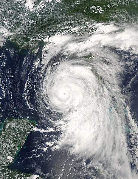
More than a million people are evacuating the coastal areas of Florida and Alabama as Hurricane Dennis steadily approaches. The first hurricane of the 2005 Atlantic hurricane season, Dennis has already been a deadly storm. It crossed over Cuba on July 8 and 9, leaving at least 10 dead, and caused additional deaths in Haiti. After re-emerging over open water, Dennis re-strengthened into a dangerous Category 3 hurricane with winds approaching 115 miles per hour when this image was taken at 2:45 p.m. EDT on July 9, 2005. The Moderate Resolution Imaging Spectroradiometer on NASA's Aqua satellite captured this image of the storm sliding up Florida's west coast. The National Hurricane Center warns that Dennis continues to strengthen and may become a powerful Category 4 hurricane before making landfall over the northern Gulf Coast on July 10. For additional information and warnings about this storm, please visit the National Hurricane Center. This image is available in additional resolutions from the MODIS Rapid Response Team. |
|||||
| 日期 | ||||||
| 來源 | https://web.archive.org/web/20071031160353/http://earthobservatory.nasa.gov/NaturalHazards/Archive/Jul2005/Dennis_AMO_2005190_lrg.jpg | |||||
| 作者 | NASA image courtesy Jacques Descloitres, MODIS Rapid Response Team, NASA GSFC | |||||
| 授權許可 (重用此檔案) |
|

檔案歷史
點選日期/時間以檢視該時間的檔案版本。
| 日期/時間 | 縮圖 | 尺寸 | 用戶 | 備註 | |
|---|---|---|---|---|---|
| 目前 | 2006年11月2日 (四) 21:43 | | 6,800 × 8,800(10.28 MB) | Good kitty(對話 | 貢獻) | == Summary == {{Information |Description=More than a million people are evacuating the coastal areas of Florida and Alabama as Hurricane Dennis steadily approaches. The first hurricane of the 2005 Atlantic hurricane season, Dennis has already been a deadl |
無法覆蓋此檔案。
檔案用途
下列4個頁面有用到此檔案:
全域檔案使用狀況
以下其他 wiki 使用了這個檔案:
- de.wikipedia.org 的使用狀況
- en.wikipedia.org 的使用狀況
- eo.wikipedia.org 的使用狀況
- zh.wikipedia.org 的使用狀況