File:Dependent territories.svg
跳转到导航
跳转到搜索

此SVG文件的PNG预览的大小:800 × 406像素。 其他分辨率:320 × 162像素 | 640 × 325像素 | 1,024 × 520像素 | 1,280 × 650像素 | 2,560 × 1,300像素 | 2,754 × 1,398像素。
原始文件 (SVG文件,尺寸为2,754 × 1,398像素,文件大小:1.05 MB)
说明
说明
添加一行文字以描述该文件所表现的内容
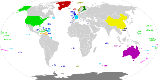
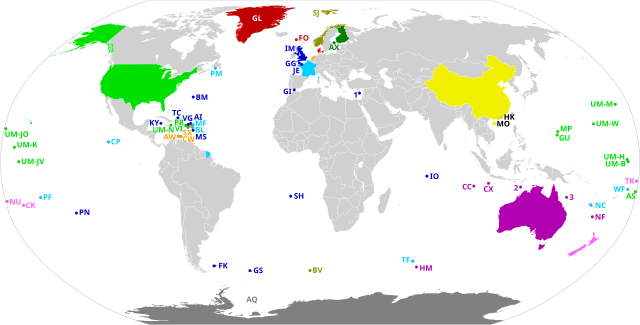
Map of the world's dependent territories and the sovereign countries on which they depend
摘要[编辑]
| 描述 |
English:
Dependent territories and their sovereign countries. All territories are labelled according to ISO 3166-1. Each territory in the United States Minor Outlying Islands is labelled UM- followed by the first letter of its name and another unique letter if needed. The following territories do not have ISO 3166-1 codes: 1: Akrotiri and Dhekelia 2: Ashmore and Cartier Islands 3: Coral Sea Islands Español: Los Territorios dependientes en el Mundo y los países soberanos de los que dependen.
Todos los territorios están etiquetados según la norma ISO 3166-1. Los siguientes territorios no tienen códigos ISO 3166-1: 1) Akrotiri y Dhekelia; 2) Islas Ashmore y Cartier; 3) Islas del Mar de CoralFrançais : Les territoires dépendants dans le monde et les pays souverains dont ils dépendent.
Tous les territoires sont labellisés selon la norme ISO 3166-1. Les territoires suivants n'ont pas de codes ISO 3166-1 : 1) Akrotiri et Dhekelia ; 2) Iles Ashmore et Cartier ; 3) Iles de la mer de CorailPortuguês: Os territórios dependentes no mundo e os países soberanos dos quais eles dependem.
Todos os territórios são rotulados de acordo com a norma ISO 3166-1. Os seguintes territórios não possuem códigos ISO 3166-1: 1) Akrotiri e Dhekelia; 2) Ashmore e Ilhas Cartier; 3) Ilhas do Mar de CorallDeutsch: Die abhängigen Gebiete in der Welt und die souveränen Länder, von denen sie abhängen.
Alle Gebiete sind gemäß ISO 3166-1 gekennzeichnet. Die folgenden Gebiete haben keine ISO 3166-1-Codes: 1) Akrotiri und Dhekelia; 2) Ashmore- und Cartier-Inseln; 3) Korallenmeerinseln |
| 日期 | |
| 来源 | 自己的作品, based on BlankMap-World.svg |
| 作者 | Heitordp |
许可协议[编辑]
我,本作品著作权人,特此采用以下许可协议发表本作品:
| 本作品采用知识共享CC0 1.0 通用公有领域贡献许可协议授权。 | |
| 采用本宣告发表本作品的人,已在法律允许的范围内,通过在全世界放弃其对本作品拥有的著作权法规定的所有权利(包括所有相关权利),将本作品贡献至公有领域。您可以复制、修改、传播和表演本作品,将其用于商业目的,无需要求授权。
|
文件历史
点击某个日期/时间查看对应时刻的文件。
| 日期/时间 | 缩略图 | 大小 | 用户 | 备注 | |
|---|---|---|---|---|---|
| 当前 | 2020年7月20日 (一) 22:56 | | 2,754 × 1,398(1.05 MB) | M.Bitton(留言 | 贡献) | Added the missing border between Morocco and Western Sahara. |
| 2020年7月12日 (日) 20:58 |  | 2,754 × 1,398(1.05 MB) | Heitordp(留言 | 贡献) | Corrected code of Heard Island and McDonald Islands, and removed color from Taiwan | |
| 2020年7月12日 (日) 12:13 |  | 2,754 × 1,398(1.08 MB) | Wiz9999(留言 | 贡献) | Replacing XAD, XAC, and XCS with 1,2, and 3 to make the map more neutral. XAD, XAC, and XCS do not represent any formal labelling/classification system to describe Akrotiri and Dhekelia, Ashmore and Cartier Islands, and Coral Sea Islands outside of this file. | |
| 2020年7月7日 (二) 22:05 |  | 2,754 × 1,398(1.05 MB) | Heitordp(留言 | 贡献) | Uploaded own work with UploadWizard |
您不可以覆盖此文件。
文件用途
没有页面使用本文件。
全域文件用途
以下其他wiki使用此文件:
- bn.wikipedia.org上的用途
- en.wikipedia.org上的用途
- eu.wikipedia.org上的用途
- mk.wikipedia.org上的用途
- pt.wikipedia.org上的用途
- simple.wikipedia.org上的用途
- tr.wikipedia.org上的用途