File:Dependent territories.svg
跳至導覽
跳至搜尋

此 SVG 檔案的 PNG 預覽的大小:800 × 406 像素。 其他解析度:320 × 162 像素 | 640 × 325 像素 | 1,024 × 520 像素 | 1,280 × 650 像素 | 2,560 × 1,300 像素 | 2,754 × 1,398 像素。
原始檔案 (SVG 檔案,表面大小:2,754 × 1,398 像素,檔案大小:1.05 MB)
說明
說明
添加單行說明來描述出檔案所代表的內容
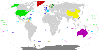
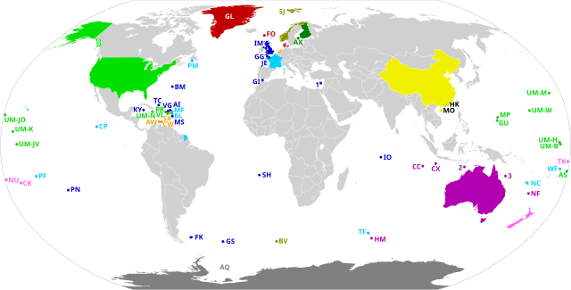
Map of the world's dependent territories and the sovereign countries on which they depend
摘要
[編輯]
| 描述 |
English:
Dependent territories and their sovereign countries. All territories are labelled according to ISO 3166-1. Each territory in the United States Minor Outlying Islands is labelled UM- followed by the first letter of its name and another unique letter if needed. The following territories do not have ISO 3166-1 codes: 1: Akrotiri and Dhekelia 2: Ashmore and Cartier Islands 3: Coral Sea Islands Español: Los Territorios dependientes en el Mundo y los países soberanos de los que dependen.
Todos los territorios están etiquetados según la norma ISO 3166-1. Los siguientes territorios no tienen códigos ISO 3166-1: 1) Akrotiri y Dhekelia; 2) Islas Ashmore y Cartier; 3) Islas del Mar de CoralFrançais : Les territoires dépendants dans le monde et les pays souverains dont ils dépendent.
Tous les territoires sont labellisés selon la norme ISO 3166-1. Les territoires suivants n'ont pas de codes ISO 3166-1 : 1) Akrotiri et Dhekelia ; 2) Iles Ashmore et Cartier ; 3) Iles de la mer de CorailPortuguês: Os territórios dependentes no mundo e os países soberanos dos quais eles dependem.
Todos os territórios são rotulados de acordo com a norma ISO 3166-1. Os seguintes territórios não possuem códigos ISO 3166-1: 1) Akrotiri e Dhekelia; 2) Ashmore e Ilhas Cartier; 3) Ilhas do Mar de CorallDeutsch: Die abhängigen Gebiete in der Welt und die souveränen Länder, von denen sie abhängen.
Alle Gebiete sind gemäß ISO 3166-1 gekennzeichnet. Die folgenden Gebiete haben keine ISO 3166-1-Codes: 1) Akrotiri und Dhekelia; 2) Ashmore- und Cartier-Inseln; 3) Korallenmeerinseln |
| 日期 | |
| 來源 | 自己的作品, based on BlankMap-World.svg |
| 作者 | Heitordp |
授權條款
[編輯]
我,本作品的著作權持有者,決定用以下授權條款發佈本作品:
| 此檔案在創用CC CC0 1.0 通用公有領域貢獻宣告之下分發。 | |
| 在此宣告之下分發本作品者,已依據各國著作權法,在全世界放棄其對本作品所擁有的著作權及所有相關相似的法律權利,從而將本作品貢獻至公有領域。您可以複製、修改、分發和演示該作品,用於任何商業用途,所有這些都不需要請求授權。
|
檔案歷史
點選日期/時間以檢視該時間的檔案版本。
| 日期/時間 | 縮圖 | 尺寸 | 用戶 | 備註 | |
|---|---|---|---|---|---|
| 目前 | 2020年7月20日 (一) 22:56 | | 2,754 × 1,398(1.05 MB) | M.Bitton(對話 | 貢獻) | Added the missing border between Morocco and Western Sahara. |
| 2020年7月12日 (日) 20:58 |  | 2,754 × 1,398(1.05 MB) | Heitordp(對話 | 貢獻) | Corrected code of Heard Island and McDonald Islands, and removed color from Taiwan | |
| 2020年7月12日 (日) 12:13 |  | 2,754 × 1,398(1.08 MB) | Wiz9999(對話 | 貢獻) | Replacing XAD, XAC, and XCS with 1,2, and 3 to make the map more neutral. XAD, XAC, and XCS do not represent any formal labelling/classification system to describe Akrotiri and Dhekelia, Ashmore and Cartier Islands, and Coral Sea Islands outside of this file. | |
| 2020年7月7日 (二) 22:05 |  | 2,754 × 1,398(1.05 MB) | Heitordp(對話 | 貢獻) | Uploaded own work with UploadWizard |
無法覆蓋此檔案。
檔案用途
沒有使用此檔案的頁面。
全域檔案使用狀況
以下其他 wiki 使用了這個檔案:
- bn.wikipedia.org 的使用狀況
- en.wikipedia.org 的使用狀況
- eu.wikipedia.org 的使用狀況
- mk.wikipedia.org 的使用狀況
- pt.wikipedia.org 的使用狀況
- simple.wikipedia.org 的使用狀況
- tr.wikipedia.org 的使用狀況