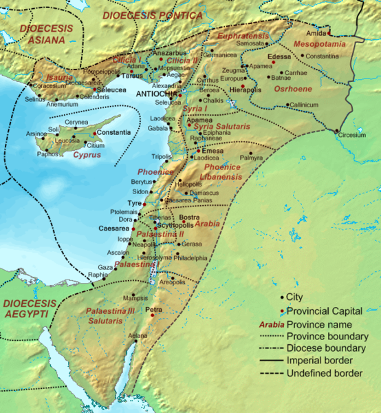
File:Dioecesis Orientis 400 AD.png
De Wikimedia Commons
Salta a la navegació
Salta a la cerca

Mida d'aquesta previsualització: 554 × 600 píxels. Altres resolucions: 222 × 240 píxels | 620 × 671 píxels.
Fitxer original (620 × 671 píxels, mida del fitxer: 373 Ko, tipus MIME: image/png)
Informació del fitxer
Dades estructurades
Llegendes
Llegendes
Afegeix una explicació d'una línia del que representa aquest fitxer
the Levant (in Latin) or Syria (in Greek) or AlSham (in Arabic/Semitic)
Resum
[modifica]| DescripcióDioecesis Orientis 400 AD.png | Map of the Diocese of the East (Dioecesis Orientis) ca. 400 AD, showing the subordinate provinces and the major cities. |
| Data | |
| Font |
Base map found at en:Topographic map#Global 1-kilometer map, otherwise self-made. Data based on maps in atlases and the internet and on contemporary sources, primarily the Notitia Dignitatum and the Synecdemus. Note: the exact course of the provincial boundaries is very uncertain and in many cases only approximate. |
| Autor | Cplakidas |
Llicència
[modifica]| Public domainPublic domainfalsefalse |
| Jo, el titular del copyright d'aquesta obra, l'allibero al domini públic. Això s'aplica a tot el món. En alguns països això pot no ser legalment possible, en tal cas: Jo faig concessió a tothom del dret d'usar aquesta obra per a qualsevol propòsit, sense cap condició llevat d'aquelles requerides per la llei. |
Historial del fitxer
Cliqueu una data/hora per veure el fitxer tal com era aleshores.
| Data/hora | Miniatura | Dimensions | Usuari/a | Comentari | |
|---|---|---|---|---|---|
| actual | 17:48, 19 set 2007 |  | 620 × 671 (373 Ko) | Cplakidas (discussió | contribucions) | {{Information |Description=Map of the en:Diocese of the East (''Dioecesis Orientis'') ca. 400 AD, showing the subordinate provinces and the major cities. |Source=Base map found at en:Topographic map#Global 1-kilometer map, otherwise self-made. |
No podeu sobreescriure aquest fitxer.
Ús del fitxer
Les 2 pàgines següents utilitzen aquest fitxer:
Ús global del fitxer
Utilització d'aquest fitxer en altres wikis:
- Utilització a ar.wikipedia.org
- Utilització a ast.wikipedia.org
- Utilització a azb.wikipedia.org
- Utilització a ba.wikipedia.org
- Utilització a be.wikipedia.org
- Utilització a bg.wikipedia.org
- Utilització a bn.wikipedia.org
- Utilització a br.wikipedia.org
- Utilització a ca.wikipedia.org
- Utilització a cy.wikipedia.org
- Utilització a de.wikipedia.org
- Utilització a el.wikipedia.org
- Utilització a en.wikipedia.org
- Decapolis
- Orient
- Bilad al-Sham
- Arab Christians
- Coele-Syria
- Al-Harith ibn Jabalah
- Antiochia ad Cragum
- Limes Arabicus
- List of revolutions and rebellions
- Mesopotamia (Roman province)
- Diocese of the East
- History of the Roman Empire
- History of Palestine
- Syria Prima
- Al-Mundhir III ibn al-Harith
- History of the Romans in Arabia
- Samaritan revolts
- Euphratensis
- Palaestina Salutaris
- Classical Anatolia
- Transjordan (region)
- Phoenice (Roman province)
Vegeu més usos globals d'aquest fitxer.