File:Discovery Expedition field of work.png
跳转到导航
跳转到搜索

本预览的尺寸:800 × 538像素。 其他分辨率:320 × 215像素 | 640 × 430像素 | 890 × 598像素。
原始文件 (890 × 598像素,文件大小:60 KB,MIME类型:image/png)
说明
说明
添加一行文字以描述该文件所表现的内容
摘要
[编辑]
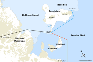
| 描述 | Map of the Discovery Expedition field of work, including three routes of explorations undertaken by members of the British National Antarctic Expedition of 1901-04 led by Robert Falcon Scott. RED line; Southern journey to Furthest South, November 1902 to February 1903. BLACK line; Western journey through Western Mountains to Polar Plateau, October–December 1903. BLUE line; Journeys to message point and Emperor Penguin colony at Cape Crozier, October 1902, September and October 1903. |
| 日期 | |
| 来源 | Underlying map from the Atlas of Antarctic Research by the United States Geological Survey (a public domain work). Includes Image:Simple compass rose.svg. |
| 作者 | Map by USGS, additional modifications by Holly Cheng |
| 其他版本 |
此文件衍生的作品: |
许可协议
[编辑]
| 我,本作品著作权人,释出本作品至公有领域。这适用于全世界。 在一些国家这可能不合法;如果是这样的话,那么: 我无条件地授予任何人以任何目的使用本作品的权利,除非这些条件是法律规定所必需的。 |
文件历史
点击某个日期/时间查看对应时刻的文件。
| 日期/时间 | 缩略图 | 大小 | 用户 | 备注 | |
|---|---|---|---|---|---|
| 当前 | 2008年5月3日 (六) 00:21 | | 890 × 598(60 KB) | Holly Cheng(留言 | 贡献) | corrected inaccuracy |
| 2008年5月2日 (五) 19:53 |  | 890 × 598(66 KB) | Holly Cheng(留言 | 贡献) | removed top border | |
| 2008年5月2日 (五) 19:43 |  | 890 × 600(63 KB) | Holly Cheng(留言 | 贡献) | {{Information |Description=Map of the ''{{w:Discovery Expedition}}'' field of work, including three routes of explorations undertaken by members of the British National Antarctic Expedition of 1901-04 led by Robert Falcon Scott |Source=Underlying map from |
您不可以覆盖此文件。
文件用途
以下2个页面使用本文件:
全域文件用途
以下其他wiki使用此文件:
- be.wikipedia.org上的用途
- da.wikipedia.org上的用途
- en.wikipedia.org上的用途
- fi.wikipedia.org上的用途
- fr.wikipedia.org上的用途
- he.wikipedia.org上的用途
- ja.wikipedia.org上的用途
- ka.wikipedia.org上的用途
- mk.wikipedia.org上的用途
- nl.wikipedia.org上的用途
- nn.wikipedia.org上的用途
- no.wikipedia.org上的用途
- pl.wikipedia.org上的用途
- pt.wikipedia.org上的用途
- ro.wikipedia.org上的用途
- vi.wikipedia.org上的用途
- zh.wikipedia.org上的用途