File:Districts in Perak.svg

原始文件 (SVG文件,尺寸为1,359 × 2,176像素,文件大小:643 KB)
说明
说明
摘要
[编辑]
| 描述 |
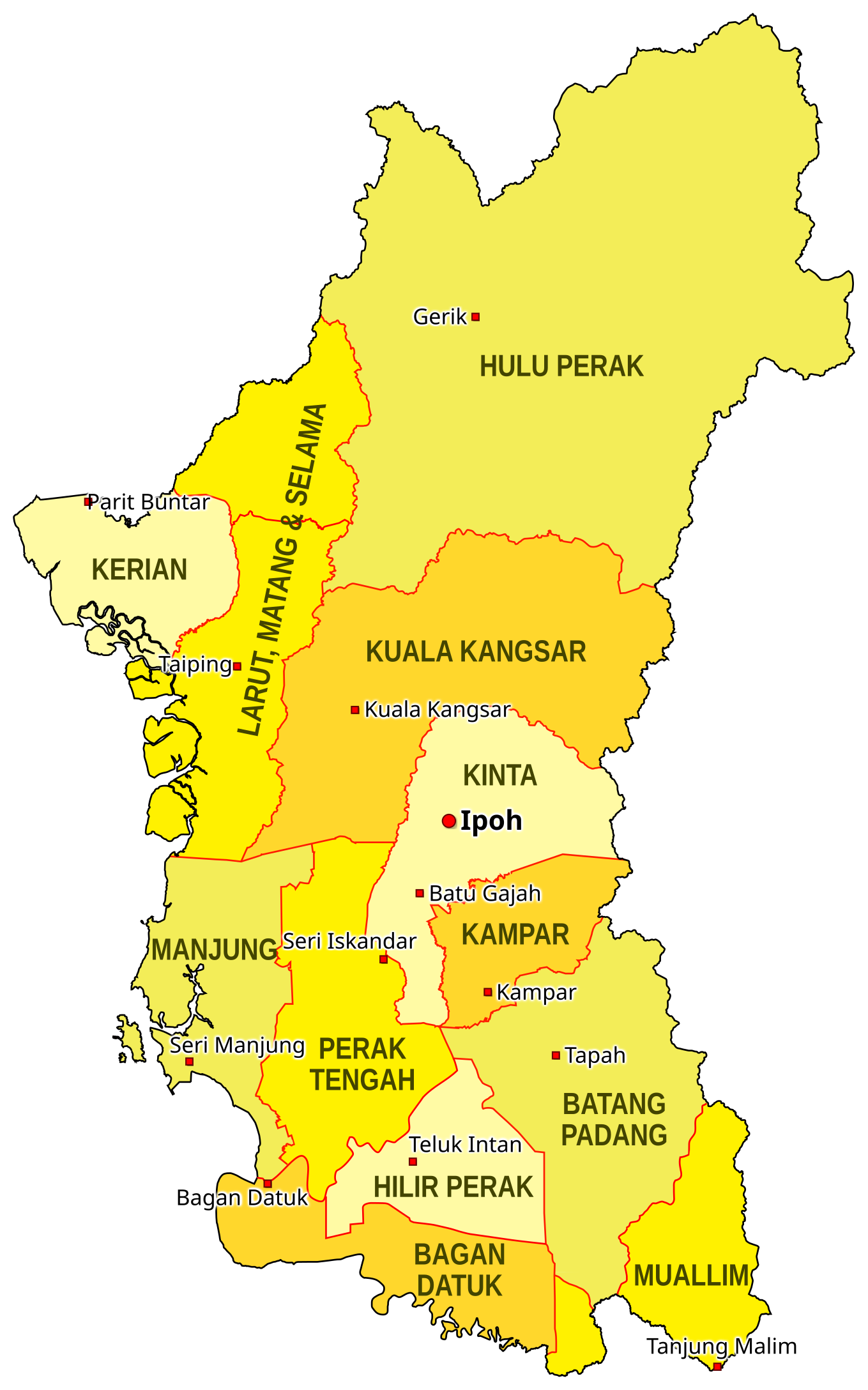
EN: This is the map of the districts of the Malaysian state of Perak as of 2018. The district borders are based on the map on the Unique Parcel Identifier site, and the location of cities are approximated based on OpenStreetMap. The borders of the districts Muallim and Bagan Datuk (declared in 2016) are based on the map on the South Perak Region website. This map is meant to only be for illustrative purposes. This map is not an authority on state district borders and should not be used for navigation. MS: Ini adalah peta daerah-daerah di negeri Perak di Malaysia pada tahun 2018. Sempadan-sempadan daerah didasarkan peta daripada laman Unique Parcel Identifier, dan kedudukan bandar-bandar dianggarkan berdasarkan peta OpenStreetMap. Sempadan daerah Muallim dan Bagan Datuk (diisytihar 2016) didasarkan peta di laman Wilayah Perak Selatan. Peta ini hanya bertujuan untuk tujuan ilustratif sahaja. Ia bukannya penentu kedudukan tepat sempadan-sempadan daerah dan tidak sepatutnya digunakan untuk navigasi. |
| 日期 | |
| 来源 | 自己的作品 |
| 作者 | SyahirSQRT2 (留言) |
许可协议
[编辑]

|
已授权您依据自由软件基金会发行的无固定段落及封面封底文字(Invariant Sections, Front-Cover Texts, and Back-Cover Texts)的GNU自由文件许可协议1.2版或任意后续版本的条款,复制、传播和/或修改本文件。该协议的副本请见“GNU Free Documentation License”。 |
- 您可以自由地:
- 共享 – 复制、发行并传播本作品
- 修改 – 改编作品
- 惟须遵守下列条件:
- 署名 – 您必须对作品进行署名,提供授权条款的链接,并说明是否对原始内容进行了更改。您可以用任何合理的方式来署名,但不得以任何方式表明许可人认可您或您的使用。
- 相同方式共享 – 如果您再混合、转换或者基于本作品进行创作,您必须以与原先许可协议相同或相兼容的许可协议分发您贡献的作品。
文件历史
点击某个日期/时间查看对应时刻的文件。
| 日期/时间 | 缩略图 | 大小 | 用户 | 备注 | |
|---|---|---|---|---|---|
| 当前 | 2018年1月22日 (一) 13:32 | | 1,359 × 2,176(643 KB) | SyahirSQRT2(留言 | 贡献) | Even brighter colors. Sorry, Commons. |
| 2018年1月22日 (一) 12:28 |  | 1,359 × 2,176(643 KB) | SyahirSQRT2(留言 | 贡献) | Tried faffing around with the colors a bit to make it brighter. Don't know if it does anything. Graphic design: I can try, but that's about it. | |
| 2018年1月12日 (五) 19:43 |  | 1,359 × 2,176(643 KB) | SyahirSQRT2(留言 | 贡献) | Added Bagan Datuk district (that's been long overdue!) | |
| 2016年1月13日 (三) 09:20 |  | 1,274 × 2,040(700 KB) | SyahirSQRT2(留言 | 贡献) | Fixed error on the "Larut, Matang & Selama" label. | |
| 2016年1月13日 (三) 09:07 |  | 1,274 × 2,040(700 KB) | SyahirSQRT2(留言 | 贡献) | {{Information |Description= '''EN''': This is the map of the districts of the Malaysian state of Perak as of 2016, when Muallim was proclaimed a separate district on January 11. Labelled on the map with squar... |
您不可以覆盖此文件。
文件用途
以下页面使用本文件:
全域文件用途
以下其他wiki使用此文件:
- en.wikipedia.org上的用途
- id.wikipedia.org上的用途
- simple.wikipedia.org上的用途
- ur.wikipedia.org上的用途
- vi.wikipedia.org上的用途
- www.wikidata.org上的用途
- zh-min-nan.wikipedia.org上的用途
- zh.wikipedia.org上的用途