File:Districts of the Ashanti Region (2012).svg
跳转到导航
跳转到搜索

此SVG文件的PNG预览的大小:744 × 524像素。 其他分辨率:320 × 225像素 | 640 × 451像素 | 1,024 × 721像素 | 1,280 × 902像素 | 2,560 × 1,803像素。
原始文件 (SVG文件,尺寸为744 × 524像素,文件大小:3.97 MB)
说明
说明
添加一行文字以描述该文件所表现的内容
摘要[编辑]
.svg&action=edit§ion=1)
| 描述 |
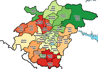
English: Map showing all 30 districts of the Ashanti Region of Ghana, including the new districts that were created in 2012. |
| 日期 | |
| 来源 | 自己的作品 |
| 作者 | Macabe5387 |
| SVG开发 |
许可协议[编辑]
.svg&action=edit§ion=2)
我,本作品著作权人,特此采用以下许可协议发表本作品:
本文件采用知识共享署名-相同方式共享 4.0 国际许可协议授权。
- 您可以自由地:
- 共享 – 复制、发行并传播本作品
- 修改 – 改编作品
- 惟须遵守下列条件:
- 署名 – 您必须对作品进行署名,提供授权条款的链接,并说明是否对原始内容进行了更改。您可以用任何合理的方式来署名,但不得以任何方式表明许可人认可您或您的使用。
- 相同方式共享 – 如果您再混合、转换或者基于本作品进行创作,您必须以与原先许可协议相同或相兼容的许可协议分发您贡献的作品。
文件历史
点击某个日期/时间查看对应时刻的文件。
| 日期/时间 | 缩略图 | 大小 | 用户 | 备注 | |
|---|---|---|---|---|---|
| 当前 | 2017年12月29日 (五) 14:43 | | 744 × 524(3.97 MB) | Macabe5387(留言 | 贡献) | Some district names were incorrect in the previous version. |
| 2017年12月29日 (五) 12:40 |  | 744 × 524(4.08 MB) | Macabe5387(留言 | 贡献) | User created page with UploadWizard |
您不可以覆盖此文件。
文件用途
以下页面使用本文件:
全域文件用途
以下其他wiki使用此文件:
- ar.wikipedia.org上的用途
- be.wikipedia.org上的用途
- ca.wikipedia.org上的用途
- ceb.wikipedia.org上的用途
- de.wikipedia.org上的用途
- dga.wikipedia.org上的用途
- en.wikipedia.org上的用途
- Districts of Ghana
- Ashanti Region
- Obuasi
- Tepa, Ghana
- Manso Nkwanta
- Ejura
- Sekyere South District
- Ahafo Ano North Municipal District
- Ahafo Ano South District
- Bekwai Municipal Assembly
- Amansie West District
- Asante Akim South Municipal District
- Atwima District
- Ejisu-Juaben Municipal District
- Ejura Sekyedumase Municipal District
- Kumasi Metropolitan Assembly
- Kwabre District
- Offinso Municipal District
- Sekyere East District
- Mampong Municipal District
- Adansi North District
- Adansi South District
- Amansie Central District
- Atwima Mponua District
- Bosomtwe District
- Obuasi Municipal Assembly
- Atwima Nwabiagya Municipal District
- Ejisu
- Template:Districts of the Ashanti Region
- Administrative divisions of Ghana
- Agogo, Ghana
- Mampong
- Konongo, Ghana
- Nsuta
- Asante Akim North District
- Sekyere West District
- Asante people
- Afigya Kwabre District
- Atwima Kwanwoma District
- Bosome Freho District
- Sekyere Central District
- Offinso North District
- Sekyere Afram Plains District
查看本文件的更多全域用途。
.svg)
.svg&oldid=712455237)