File:Divalia Fossa IOTD-260.jpg

Originaldatei (2.700 × 1.600 Pixel, Dateigröße: 739 KB, MIME-Typ: image/jpeg)
Bildtexte
Kurzbeschreibungen
Beschreibung
[Bearbeiten]
| Beschreibung |
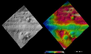
English: Divalia Fossa on 4 Vesta.
Original caption: Apparent brightness and topography images of Divalia Fossa and Rubria and Occia craters The left-hand image is a Dawn FC (framing camera) image, which shows the apparent brightness of Vesta’s surface. The right-hand image is based on this apparent brightness image, which has had a color-coded height representation of the topography overlain onto it. The topography is calculated from a set of images that were observed from different viewing directions, which allows stereo reconstruction. The various colors correspond to the height of the area. The white and red areas in the topography image are the highest areas and the blue areas are the lowest areas. These images show a part of the large trough, Divalia Fossa, which encircles most of Vesta’s equator. Divalia Fossa is visible in both the apparent brightness image and the topography image: it is the approximately 10 kilometer (6 mile) wide depression that runs from the left corner to the right corner of the images. The top rim of Divalia Fossa is especially clear in the topography image. A number of smaller troughs above and below Divalia Fossa are parallel to it. Rubria and Occia craters straddle Divalia Fossa: Rubria is the crater with dark and bright material above Divalia Fossa and Occia is the crater with bright and dark material below. These images are located in Vesta’s Gegania quadrangle, just south of Vesta’s equator. NASA’s Dawn spacecraft obtained the apparent brightness image with its framing camera on Oct. 16, 2011. This image was taken through the camera’s clear filter. The distance to the surface of Vesta is 700 kilometers (435 miles) and the image has a resolution of about 70 meters (230 feet) per pixel. This image was acquired during the HAMO (high-altitude mapping orbit) phase of the mission. These images are lambert-azimuthalmap projected. |
| Datum | |
| Quelle | http://dawn.jpl.nasa.gov/multimedia/imageoftheday/image.asp?date=20120711 |
| Urheber | NASA/ JPL |
Lizenz
[Bearbeiten]
| Diese Datei ist gemeinfrei (public domain), da sie von der NASA erstellt worden ist. Die NASA-Urheberrechtsrichtlinie besagt, dass „NASA-Material nicht durch Urheberrecht geschützt ist, wenn es nicht anders angegeben ist“. (NASA-Urheberrechtsrichtlinie-Seite oder JPL Image Use Policy). | ||
 |
Warnung:
|
Ursprüngliches Datei-Logbuch
[Bearbeiten]
| Version vom | Maße | Benutzer | Kommentar |
|---|---|---|---|
| 2012-09-15 09:46 | 2700×1600× (756667 bytes) | Kwamikagami | Uploading a public-domain item using [[Wikipedia:File_Upload_Wizard|File Upload Wizard]] |

|
Die Kategorien dieses Bildes sollten überprüft werden. Prüfe sie jetzt!
|
Dateiversionen
Klicke auf einen Zeitpunkt, um diese Version zu laden.
| Version vom | Vorschaubild | Maße | Benutzer | Kommentar | |
|---|---|---|---|---|---|
| aktuell | 11:02, 25. Nov. 2015 | | 2.700 × 1.600 (739 KB) | PlanetUser (Diskussion | Beiträge) | Transferred from en.wikipedia |
Du kannst diese Datei nicht überschreiben.
Dateiverwendung
Keine Seiten verwenden diese Datei.
Globale Dateiverwendung
Die nachfolgenden anderen Wikis verwenden diese Datei:
- Verwendung auf de.wikipedia.org
- Verwendung auf en.wikipedia.org
- Verwendung auf en.wikiversity.org
- Verwendung auf mk.wikipedia.org
- Verwendung auf ro.wikipedia.org
- Verwendung auf ru.wikipedia.org
- Verwendung auf uk.wikipedia.org
- Verwendung auf zh.wikipedia.org