File:Djibouti relief location map.jpg
跳至導覽
跳至搜尋

預覽大小:599 × 600 像素。 其他解析度:240 × 240 像素 | 479 × 480 像素 | 767 × 768 像素 | 1,023 × 1,024 像素 | 1,540 × 1,542 像素。
原始檔案 (1,540 × 1,542 像素,檔案大小:1.26 MB,MIME 類型:image/jpeg)
說明
說明
添加單行說明來描述出檔案所代表的內容
| 描述 |
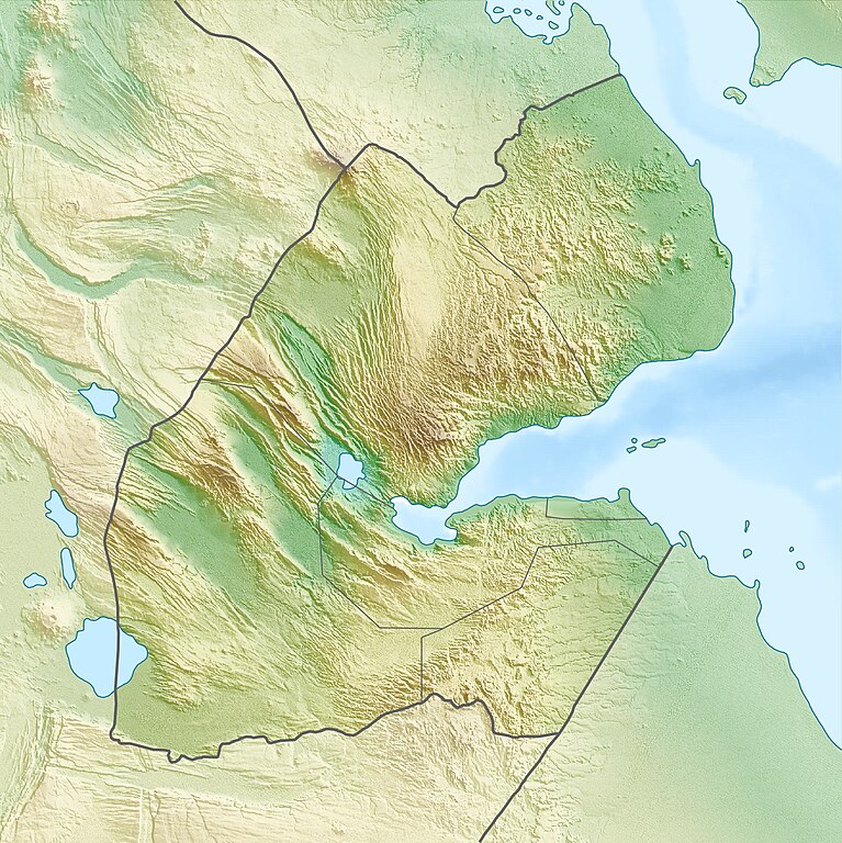
Deutsch: Physische Positionskarte von Dschibuti
Quadratische Plattkarte. Geographische Begrenzung der Karte:
English: Physical location map of Djibouti
Equirectangular projection. Geographic limits of the map:
|
| 日期 | |
| 來源 | 自己的作品, using map data from administrative map by NordNordWest. The relief was created from SRTM-3 relief data |
| 作者 | Carport |
| 授權許可 (重用此檔案) |
此檔案採用創用CC 姓名標示-相同方式分享 3.0 未在地化版本授權條款。
|
| 其他版本 |
|

檔案歷史
點選日期/時間以檢視該時間的檔案版本。
| 日期/時間 | 縮圖 | 尺寸 | 使用者 | 備註 | |
|---|---|---|---|---|---|
| 目前 | 2010年4月17日 (六) 08:53 | | 1,540 × 1,542(1.26 MB) | Carport(留言 | 貢獻) | {{Information |Description={{de|Physische Positionskarte von {{w|Dschibuti|3=de}}}} Quadratische Plattkarte. Geographische Begrenzung der Karte: * N: 12.9° N * S: 10.7° N * W: 41.5° O * O: 43.7° O {{en|Physical location map of {{w|Djibouti}}}} Equirec |
無法覆蓋此檔案。
檔案用途
下列頁面有用到此檔案:
全域檔案使用狀況
以下其他 wiki 使用了這個檔案:
- ar.wikipedia.org 的使用狀況
- ast.wikipedia.org 的使用狀況
- az.wikipedia.org 的使用狀況
- ba.wikipedia.org 的使用狀況
- be.wikipedia.org 的使用狀況
- bg.wikipedia.org 的使用狀況
- bn.wikipedia.org 的使用狀況
- bs.wikipedia.org 的使用狀況
- ceb.wikipedia.org 的使用狀況
- ce.wikipedia.org 的使用狀況
- ckb.wikipedia.org 的使用狀況
- cs.wikipedia.org 的使用狀況
- da.wikipedia.org 的使用狀況
- de.wikipedia.org 的使用狀況
- Dschibuti
- Assalsee (Dschibuti)
- Abbe-See
- Arta (Dschibuti)
- Golf von Tadjoura
- Vorlage:Positionskarte Dschibuti
- Wikipedia:Kartenwerkstatt/Positionskarten/Afrika
- Ardoukoba
- Benutzer:Carport/Galerie
- Holhol
- Ali Adde
- Loyada
- Goda-Massiv
- Mousa Alli
- Doumeira
- Musha (Insel)
- Sawabi-Inseln
- Oueah
- Ghoubbet-el-Kharab
- Damerjog
- Musha-Inseln
- Maskal
檢視此檔案的更多全域使用狀況。