File:Doksuri 2012 track.png
跳去導覽
跳去搵嘢

預覽大細:800 × 495 像素。 第啲解像度:320 × 198 像素 | 640 × 396 像素 | 1,024 × 633 像素 | 1,280 × 791 像素 | 2,700 × 1,669 像素。
原本檔案 (2,700 × 1,669 像素,檔案大細:2.44 MB ,MIME類型:image/png)
Captions
Captions
Add a one-line explanation of what this file represents
摘要
| 描述 |
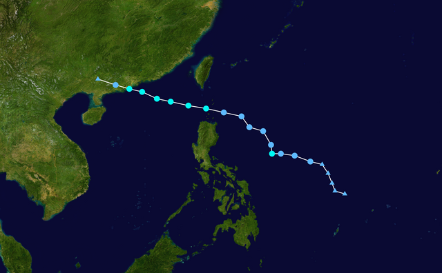
English: Track map of Tropical Storm Doksuri of the 2012 Pacific typhoon season. The points show the location of the storm at 6-hour intervals. The colour represents the storm's maximum sustained wind speeds as classified in the (see below), and the shape of the data points represent the nature of the storm, according to the legend below. Tropical depression (≤38 mph, ≤62 km/h)
Tropical storm (39–73 mph, 63–118 km/h)
Category 1 (74–95 mph, 119–153 km/h)
Category 2 (96–110 mph, 154–177 km/h)
Category 3 (111–129 mph, 178–208 km/h)
Category 4 (130–156 mph, 209–251 km/h)
Category 5 (≥157 mph, ≥252 km/h)
Unknown
Storm type |
||
| 日期 | 2012-06-25–2012-06-30 | ||
| 來源 | Created by Supportstorm using Wikipedia:WikiProject Tropical cyclones/Tracks. The background image is from NASA. Tracking data is from the Joint Typhoon Warning Center[1]. | ||
| 作者 | Supportstorm | ||
| Source code | Track map data table, if present below, is in HURDAT2 or ATCF format. See format details in [2] and [3], respectively.
|
協議[編輯]
| This work has been released into the public domain by its author, Supportstorm. This applies worldwide. In some countries this may not be legally possible; if so: Supportstorm grants anyone the right to use this work for any purpose, without any conditions, unless such conditions are required by law. |
檔案歷史
撳個日期/時間去睇響嗰個時間出現過嘅檔案。
| 日期/時間 | 縮圖 | 尺寸 | 用戶 | 註解 | |
|---|---|---|---|---|---|
| 現時 | 2020年4月9號 (四) 03:17 | | 2,700 × 1,669(2.44 MB) | Supportstorm(傾偈 | 貢獻) | JTWC/JMA data |
| 2014年12月9號 (二) 18:39 |  | 2,700 × 1,669(2.42 MB) | Supportstorm(傾偈 | 貢獻) | IBTrACS version | |
| 2013年4月26號 (五) 12:59 |  | 2,000 × 1,236(1.2 MB) | Cyclonebiskit(傾偈 | 貢獻) | I'm crying right now | |
| 2012年10月24號 (三) 05:48 |  | 1,024 × 633(487 KB) | Earth100(傾偈 | 貢獻) | RSMC Best Track Data added | |
| 2012年6月30號 (六) 08:01 |  | 1,024 × 633(442 KB) | Keith Edkins(傾偈 | 貢獻) | Updated | |
| 2012年6月29號 (五) 19:26 |  | 1,024 × 633(389 KB) | Keith Edkins(傾偈 | 貢獻) | Updated | |
| 2012年6月27號 (三) 11:50 |  | 1,024 × 633(258 KB) | Keith Edkins(傾偈 | 貢獻) | ||
| 2012年6月25號 (一) 07:36 |  | 1,024 × 633(225 KB) | Keith Edkins(傾偈 | 貢獻) | {{Information |Description={{en|Track map of JMA Tropical Depression 10 of the 2012 Pacific typhoon season (95W.INVEST at NRL). The points show the location of th... |
你無得衾咗個檔案。
檔案用途
以下嘅1版用到呢個檔:
全域檔案使用情況
下面嘅維基都用緊呢個檔案:
- de.wikipedia.org嘅使用情況
- en.wikipedia.org嘅使用情況
- ja.wikipedia.org嘅使用情況
- ko.wikipedia.org嘅使用情況
- pt.wikipedia.org嘅使用情況
- th.wikipedia.org嘅使用情況
- vi.wikipedia.org嘅使用情況
- zh-yue.wikipedia.org嘅使用情況
- zh.wikipedia.org嘅使用情況