File:DomTorenUtrechtNederland.jpg
跳至導覽
跳至搜尋

預覽大小:320 × 599 像素。 其他解析度:256 × 480 像素 | 410 × 768 像素 | 547 × 1,024 像素 | 1,763 × 3,300 像素。
原始檔案 (1,763 × 3,300 像素,檔案大小:3.64 MB,MIME 類型:image/jpeg)
說明
說明
添加單行說明來描述出檔案所代表的內容
|
|
摘要
[編輯]|
This is an image of rijksmonument number 36075 Information from structured data: |
| 描述 |
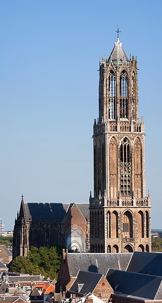
English: The Dom Tower in Utrecht, the Netherlands is one of the best known landmarks of this country. This gothic tower is the highest church tower (112,5 metres/368 feet) in the Netherlands and was built between 1321 and 1382 as part of the Cathedral of St. Martin. The resolution of the original photograph is 7768*4150.
Nederlands: De Domtoren in Utrecht, Nederland is één van de bekendste gebouwen van het land. Deze gotische toren is de hoogste kerktoren (112,5 meter) van Nederland en is gebouw tussen 1321 en 1382 als onderdeel van de Kathedraal van de Heilige Maarten. De resolutie van de oorspronkelijke foto is 7768*4150.
Français : La Cathédrale Saint-Martin d'Utrecht aux Pays-Bas. |
| 日期 | |
| 來源 | 自己的作品 |
| 作者 | Massimo Catarinella |
| 授權許可 (重用此檔案) |
See license, attribution required - contact me to discuss less restrictive commercial licensing terms by email Special:EmailUser/Massimo Catarinella or leave a message on my talk page |
| 其他版本 |
|

| 目標地點 | | 位於此地的本圖片與其他圖片: OpenStreetMap |
|---|
| 拍攝地點 | | 位於此地的本圖片與其他圖片: OpenStreetMap |
|---|
授權條款
[編輯]
我,本作品的著作權持有者,決定用以下授權條款發佈本作品:
此檔案採用創用CC 姓名標示 3.0 未在地化版本授權條款。
- 您可以自由:
- 分享 – 複製、發佈和傳播本作品
- 重新修改 – 創作演繹作品
- 惟需遵照下列條件:
- 姓名標示 – 您必須指名出正確的製作者,和提供授權條款的連結,以及表示是否有對內容上做出變更。您可以用任何合理的方式來行動,但不得以任何方式表明授權條款是對您許可或是由您所使用。
檔案歷史
點選日期/時間以檢視該時間的檔案版本。
| 日期/時間 | 縮圖 | 尺寸 | 使用者 | 備註 | |
|---|---|---|---|---|---|
| 目前 | 2009年8月31日 (一) 20:03 | | 1,763 × 3,300(3.64 MB) | Massimo Catarinella(留言 | 貢獻) | Slightly bigger resolution |
| 2009年8月31日 (一) 17:28 |  | 1,603 × 3,000(3.03 MB) | Massimo Catarinella(留言 | 貢獻) | {{Information |Description={{en|1=The Dom Tower in Utrecht, the Netherlands is one of the most well known landmarks of this country. This gothic tower is the highest church tower (112,5 metres/368 feet) in the Netherlands and was built between 1321 and 13 |
無法覆蓋此檔案。
檔案用途
下列8個頁面有用到此檔案:
- User:Basvb/Nederland
- User talk:Massimo Catarinella
- Commons:Quality images/Subject/Places/Man made structures/Buildings, Exterior/Part 1a
- Commons:Quality images candidates/Archives September 2009
- Commons talk:Quality images/Subject/Places/Man made structures
- Category:Utrecht Dom Tower
- Category:Utrecht Dom church
- Category:Views from Utrecht Dom Tower
全域檔案使用狀況
以下其他 wiki 使用了這個檔案:
- ang.wikipedia.org 的使用狀況
- ar.wikipedia.org 的使用狀況
- ast.wikipedia.org 的使用狀況
- bn.wikipedia.org 的使用狀況
- ca.wikipedia.org 的使用狀況
- cs.wikipedia.org 的使用狀況
- de.wikipedia.org 的使用狀況
- Niederlande
- Utrecht
- Liste der höchsten Sakralgebäude
- Erzbistum Utrecht (römisch-katholisch)
- Liste der Kathedralen und Basiliken in den BeNeLux-Ländern
- Utrechter Dom
- Top 100 der niederländischen Kulturdenkmäler
- Liste der Backsteinbauwerke der Gotik in den Niederlanden
- Benutzer:Ulamm/Provinz Utrecht
- Benutzer:Ulamm/Reise an der Backsteingrenze
- Benutzer:Ulamm/Backsteinbauwerke der Gotik in den Niederlanden
- Benutzer:Afus199620/Liste der höchsten Gebäude in den Niederlanden
- de.wikivoyage.org 的使用狀況
- de.wiktionary.org 的使用狀況
- en.wikipedia.org 的使用狀況
- Dom Tower of Utrecht
- St. Martin's Cathedral, Utrecht
- List of tallest church buildings
- Religion in the Netherlands
- User:Massimo Catarinella
- List of Rijksmonuments
- Wikipedia:Featured picture candidates/September-2009
- Wikipedia:Featured picture candidates/Domtoren, Utrecht
- Brabantine Gothic
- List of tallest buildings in the Netherlands
- User:Ulamm/List of Gothic brick buldings in the Netherlands
- List of Gothic brick buildings in the Netherlands
- en.wikivoyage.org 的使用狀況
- eo.wikipedia.org 的使用狀況
- es.wikipedia.org 的使用狀況
- eu.wikipedia.org 的使用狀況
- fi.wikipedia.org 的使用狀況
- fr.wikipedia.org 的使用狀況
- fy.wikipedia.org 的使用狀況
檢視此檔案的更多全域使用狀況。