File:Dominica, administrative divisions - en - monochrome.svg
Siirry navigaatioon
Siirry hakuun

Tämän PNG-esikatselun koko koskien SVG-tiedostoa: 405 × 599 kuvapistettä. Muut resoluutiot: 162 × 240 kuvapistettä | 324 × 480 kuvapistettä | 519 × 768 kuvapistettä | 692 × 1 024 kuvapistettä | 1 384 × 2 048 kuvapistettä | 2 500 × 3 700 kuvapistettä.
Alkuperäinen tiedosto (SVG-tiedosto; oletustarkkuus 2 500 × 3 700 kuvapistettä; tiedostokoko 119 KiB)
Kuvatekstit
Kuvatekstit
Lisää yhden rivin pituinen kuvaus tästä tiedostosta
Yhteenveto[muokkaa]
| Kuvaus |
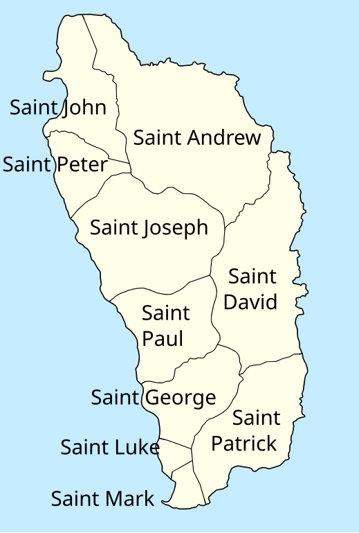
Македонски: Карта на парохиите во Доминика на англиски.
English: Map of the parishes of Dominica in English. |
| Päiväys | |
| Lähde | Oma teos |
| Tekijä | MacedonianBoy |
| Muut versiot | Macedonian version |
Lisenssi[muokkaa]
Minä, tämän teoksen tekijänoikeuksien haltija, julkaisen täten tämän teoksen seuraavalla lisenssillä:
Tämä tiedosto on lisensoitu Creative Commons Nimeä-JaaSamoin 3.0 Ei sovitettu -lisenssillä.
- Voit:
- jakaa – kopioida, levittää ja esittää teosta
- remiksata – valmistaa muutettuja teoksia
- Seuraavilla ehdoilla:
- nimeäminen – Sinun on mainittava lähde asianmukaisesti, tarjottava linkki lisenssiin sekä merkittävä, mikäli olet tehnyt muutoksia. Voit tehdä yllä olevan millä tahansa kohtuullisella tavalla, mutta et siten, että annat ymmärtää lisenssinantajan suosittelevan sinua tai teoksen käyttöäsi.
- jaa samoin – Jos muutat tai perustat tähän työhön, voit jakaa tuloksena syntyvää työtä vain tällä tai tämän kaltaisella lisenssillä.
Tiedoston historia
Päiväystä napsauttamalla näet, millainen tiedosto oli kyseisellä hetkellä.
| Päiväys | Pienoiskuva | Koko | Käyttäjä | Kommentti | |
|---|---|---|---|---|---|
| nykyinen | 17. heinäkuuta 2012 kello 18.01 | | 2 500 × 3 700 (119 KiB) | MacedonianBoy (keskustelu | muokkaukset) | ss |
| 17. heinäkuuta 2012 kello 16.03 |  | 2 500 × 3 700 (119 KiB) | MacedonianBoy (keskustelu | muokkaukset) | {{Information |Description ={{en|1=ss}} |Source ={{own}} |Author =MacedonianBoy |Date = |Permission = |other_versions = }} |
Et voi tallentaa uutta tiedostoa tämän tilalle.
Tiedoston käyttö
Seuraava sivu käyttää tätä tiedostoa:
- File:Parishes of Dominica - en.svg (tiedosto-ohjaus)
Tiedoston järjestelmänlaajuinen käyttö
Seuraavat muut wikit käyttävät tätä tiedostoa:
- Käyttö kohteessa ca.wikipedia.org
- Käyttö kohteessa en.wikipedia.org
- Käyttö kohteessa es.wikipedia.org
- Käyttö kohteessa fa.wikipedia.org
- Käyttö kohteessa fi.wikipedia.org
- Käyttö kohteessa fr.wikipedia.org
- Käyttö kohteessa id.wikipedia.org
- Käyttö kohteessa ja.wikipedia.org
- Käyttö kohteessa mt.wikipedia.org
- Käyttö kohteessa sco.wikipedia.org
- Käyttö kohteessa simple.wikipedia.org
- Käyttö kohteessa zh.wikipedia.org
Luokat:
- Parishes in Dominica
- English-language SVG maps
- SVG labeled maps of administrative divisions of Dominica (location map scheme)
- SVG labeled maps of administrative divisions of countries of North America (location map scheme) (monochrome scheme)
- SVG labeled maps of administrative divisions of countries of North America (location map scheme) (english)