File:Dubaiworld.jpg
Une page de Wikimedia Commons, la médiathèque libre.
Aller à la navigation
Aller à la recherche
- Fichier
- Historique du fichier
- Utilisations locales du fichier
- Utilisations du fichier sur d’autres wikis
- Métadonnées

Taille de cet aperçu : 780 × 599 pixels. Autres résolutions : 312 × 240 pixels | 625 × 480 pixels | 999 × 768 pixels | 1 280 × 984 pixels | 1 335 × 1 026 pixels.
Fichier d’origine (1 335 × 1 026 pixels, taille du fichier : 811 kio, type MIME : image/jpeg)
Informations sur le fichier
Données structurées
Légendes
Légendes
Ajoutez en une ligne la description de ce que représente ce fichier
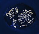
The World Islands
| DescriptionDubaiworld.jpg |
English: The World Archipelago, Persian Gulf. The image shows the project on February 5, 2009. All the continents are represented (the “map” is tilted toward the left). A breakwater surrounds the archipelago, and its role is obvious: outside the perimeter, especially to the northwest, the waters of the Gulf ripple with waves that would wear the artificial islands away. |
|||
| Date | (UTC) | |||
| Source | ||||
| Auteur |
|
|||
| Autres versions |
|
| Cette image a été retouchée, ce qui signifie qu'elle a été modifiée par ordinateur et est différente de l'image d'origine. Liste des modifications : crop image. L'image d'origine se trouve ici : Dubaiworld ast 2009036 lrg.jpg:
|
| Public domainPublic domainfalsefalse |
| Ce fichier provient de la NASA. Sauf exception, les documents créés par la NASA ne sont pas soumis à copyright. Pour plus d'informations, voir la politique de copyright de la NASA. |  | |
 |
Attention :
|
Journal des téléversements d’origine[modifier]
This image is a derivative work of the following images:
- File:Dubaiworld_ast_2009036_lrg.jpg licensed with PD-USGov-NASA
- 2009-03-26T07:59:18Z Shizhao 3000x3000 (2772491 Bytes) {{Information |Description={{en|1=The World Archipelago, Persian Gulf. The image shows the project on February 5, 2009. All the continents are represented (the “map” is tilted toward the left). A breakwater surrounds the
Téléversé avec derivativeFX
Historique du fichier
Cliquer sur une date et heure pour voir le fichier tel qu'il était à ce moment-là.
| Date et heure | Vignette | Dimensions | Utilisateur | Commentaire | |
|---|---|---|---|---|---|
| actuel | 27 novembre 2009 à 07:50 |  | 1 335 × 1 026 (811 kio) | Wikiarius (d | contributions) | {{Information |Description={{en|1=The World Archipelago, Persian Gulf. The image shows the project on February 5, 2009. All the continents are represented (the “map” is tilted toward the left). A breakwater surrounds the archipelago, and its role is |
Vous ne pouvez pas remplacer ce fichier.
Utilisations locales du fichier
Les 2 pages suivantes utilisent ce fichier :
Utilisations du fichier sur d’autres wikis
Les autres wikis suivants utilisent ce fichier :
- Utilisation sur ar.wikipedia.org
- Utilisation sur arz.wikipedia.org
- Utilisation sur ast.wikipedia.org
- Utilisation sur bn.wikipedia.org
- Utilisation sur ca.wikipedia.org
- Utilisation sur ceb.wikipedia.org
- Utilisation sur cs.wikipedia.org
- Utilisation sur en.wikipedia.org
- Utilisation sur eu.wikipedia.org
- Utilisation sur fa.wikipedia.org
- Utilisation sur fi.wikipedia.org
- Utilisation sur fr.wikipedia.org
- Utilisation sur he.wikipedia.org
- Utilisation sur hu.wikipedia.org
- Utilisation sur it.wikipedia.org
- Utilisation sur ja.wikipedia.org
- Utilisation sur ka.wikipedia.org
- Utilisation sur lt.wikipedia.org
- Utilisation sur mg.wikipedia.org
- Utilisation sur nn.wikipedia.org
- Utilisation sur pl.wikipedia.org
- Utilisation sur pt.wikipedia.org
- Utilisation sur ro.wikipedia.org
- Utilisation sur ru.wikipedia.org
- Utilisation sur sk.wikipedia.org
- Utilisation sur sv.wikipedia.org
- Utilisation sur ta.wikipedia.org
- Utilisation sur uk.wikipedia.org
- Utilisation sur vi.wikipedia.org
- Utilisation sur www.wikidata.org
- Utilisation sur zh.wikipedia.org
Métadonnées
Ce fichier contient des informations supplémentaires, probablement ajoutées par l'appareil photo numérique ou le numériseur utilisé pour le créer.
Si le fichier a été modifié depuis son état original, certains détails peuvent ne pas refléter entièrement l'image modifiée.
| _error | 0 |
|---|
