File:EB1 Plate LXXXVII Fig. 2 World.png
跳转到导航
跳转到搜索

本预览的尺寸:800 × 448像素。 其他分辨率:320 × 179像素 | 640 × 358像素 | 1,024 × 573像素 | 1,280 × 717像素 | 2,768 × 1,550像素。
原始文件 (2,768 × 1,550像素,文件大小:3.34 MB,MIME类型:image/png)
说明
说明
添加一行文字以描述该文件所表现的内容
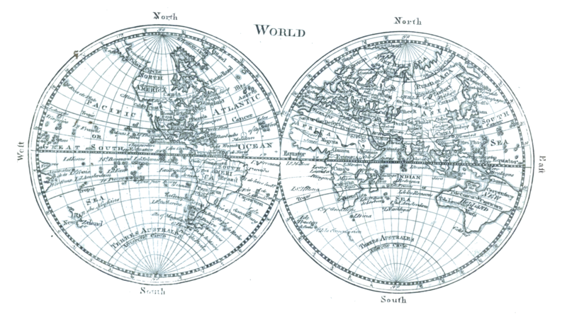
Map of the world c. 1761
摘要
[编辑]| 描述 |
English: A map of the world as two equatorial orthographic projections of the western and eastern hemispheres as known c. 1761 from Plate LXXXVII from the Encyclopaedia Britannica, 1st ed. This map contains examples of: New Holland (Australia), Baffin Bay, Baffin Island, Cape Blanco, New Albion, Viceroyalty of New Spain, Nova Scotia, Viceroyalty of Peru, Viceroyalty of New Granada, unspecified phantom islands, Terra incognita, Saint Helena, Khoikhoi, South East Cape, Van Diemen's Land, Gulf of Carpentaria, New Britain, Nuytsland, Tartary, Veneto, Novaya Zemlya, Guinea, Sahara, Jerusalem, Arabia |
| 日期 | Drawn 1761, reprinted 1763 & 1764, edited & reengraved 1771. |
| 来源 | Encyclopaedia Britannica, 1st ed., Vol. II, p. 680 ff. Uncredited reprint of Maps 1 & 2 in the 1763 (reprinted 1764) A New General and Universal Atlas... |
| 作者 | Andrew Dury, engraved by Thomas Kitchen. Credited to Andrew Bell, engraver. |
| 其他版本 |
|


许可协议
[编辑]
|
本作品在其来源国以及其他著作权期限是作者逝世后70年或以下的国家和地区属于公有领域。 | |
| 本文件已被确认为免除已知的著作权法限制(包括所有相关权利)。 | |
| 注解 | 该图片含有注解:在维基媒体共享资源上查看注解 |
文件历史
点击某个日期/时间查看对应时刻的文件。
| 日期/时间 | 缩略图 | 大小 | 用户 | 备注 | |
|---|---|---|---|---|---|
| 当前 | 2023年1月15日 (日) 20:15 | | 2,768 × 1,550(3.34 MB) | LlywelynII(留言 | 贡献) | Uploaded a work by Andrew Bell, engraver. from ''Encyclopaedia Britannica'', 1st ed., Vol. II, [https://archive.org/details/1771EncyclopediaBritannicaNLS/First%20edition%2C%201771%20-%20Encyclopaedia%20Britannica%3B%20or%2C%20A%20dictionary%20of%20arts%20and%20sciences%2C%20compiled%20upon%20a%20new%20plan%20%E2%80%A6%2C%20Volume%202%2C%20C-L/page/n649/mode/2up p. 680 ff.] with UploadWizard |
您不可以覆盖此文件。
文件用途
全域文件用途
以下其他wiki使用此文件:
- en.wikisource.org上的用途
分类:
- Maps of the world without Antarctica
- Maps of the world with orthographic projection
- 1770s maps of the world
- 18th-century double hemisphere world maps
- Andrew Dury
- Maps by Thomas Kitchin
- Maps with Nicolosi globular projection
- Multilingual maps
- Maps using Ferro prime meridian
- Maps connecting Australia and New Guinea
- Company Land