File:ECDM 20221028 FL Nigeria.pdf
Zur Navigation springen
Zur Suche springen

Größe der JPG-Vorschau dieser PDF-Datei: 800 × 566 Pixel. Weitere Auflösungen: 320 × 226 Pixel | 640 × 453 Pixel | 1.024 × 725 Pixel | 1.280 × 906 Pixel | 2.479 × 1.754 Pixel.
Originaldatei (2.479 × 1.754 Pixel, Dateigröße: 1,43 MB, MIME-Typ: application/pdf)
Bildtexte
Kurzbeschreibungen
Ergänze eine einzeilige Erklärung, was diese Datei darstellt.
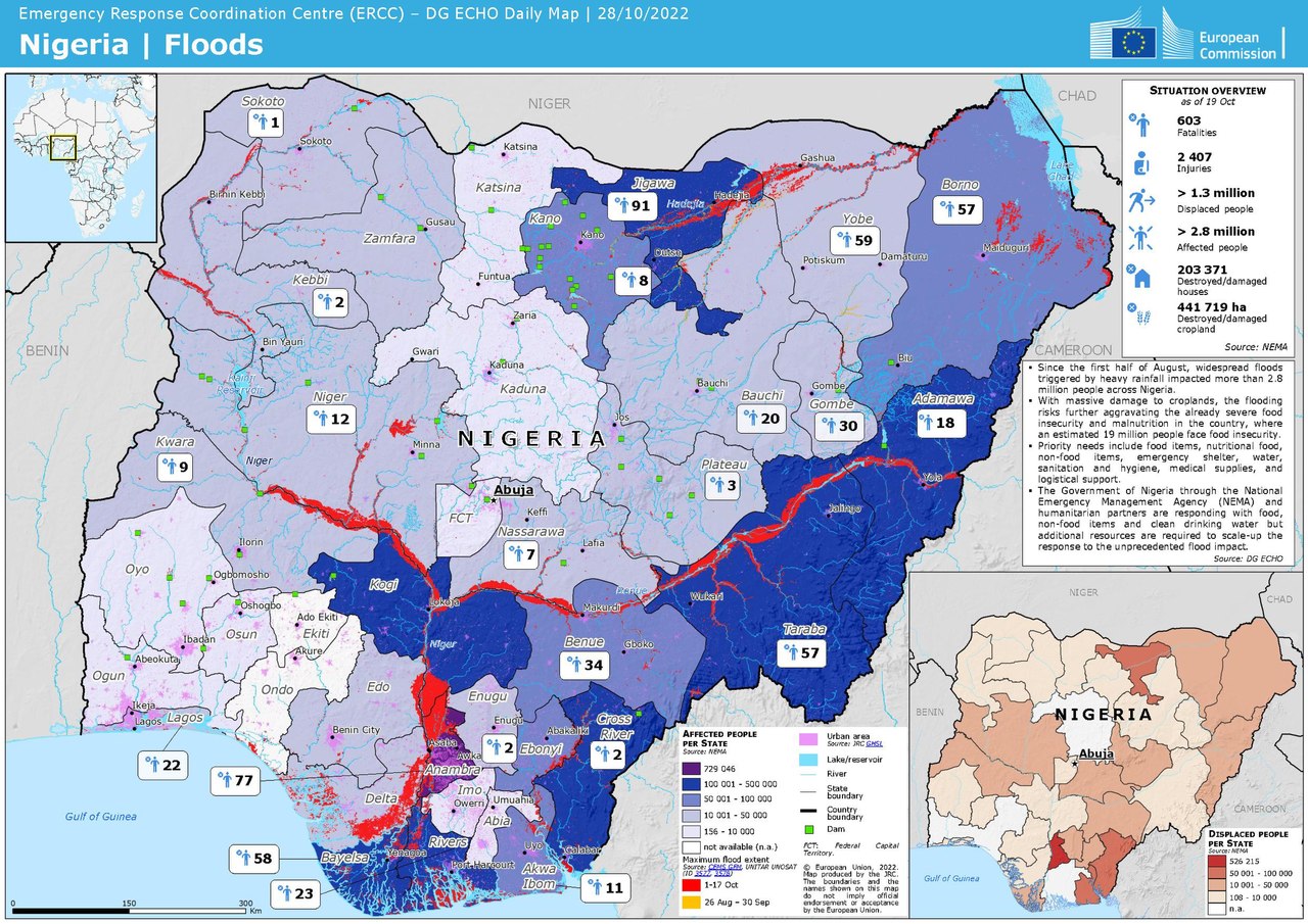
Nigeria | Floods
Beschreibung
[Bearbeiten]| Beschreibung |
English: Nigeria | Floods - ECHO Daily Map of 28 October 2022
|
| Datum | |
| Quelle | https://erccportal.jrc.ec.europa.eu/ECHO-Products/Maps#/maps/4270 |
| Urheber | ERCC - Emergency Response Coordination Centre; Sources: GDACS, NEMA, DG ECHO, CEMS GFM, UNITAR-UNOSAT, JRC-GHSL |
Lizenz
[Bearbeiten]Public documents (any content whatever its medium) produced by the Commission or by entities on its behalf published by the Commission or the Publications Office or which have not been published for economic or other practical reasons, such as studies, reports and other data shall be made available for reuse unless otherwise specified[1] without restrictions according to 2011/833/EU: Commission Decision of 12 December 2011 on the reuse of Commission documents
Note: Content on ec.europa.eu or its data portal is published with the specified restrictions of the CC BY 4.0 license.
| |
Dateiversionen
Klicke auf einen Zeitpunkt, um diese Version zu laden.
| Version vom | Vorschaubild | Maße | Benutzer | Kommentar | |
|---|---|---|---|---|---|
| aktuell | 22:08, 2. Nov. 2022 |  | 2.479 × 1.754 (1,43 MB) | Lupe (Diskussion | Beiträge) | Uploaded a work by ERCC - Emergency Response Coordination Centre; Sources: GDACS, NEMA, DG ECHO, CEMS GFM, UNITAR-UNOSAT, JRC-GHSL from https://erccportal.jrc.ec.europa.eu/ECHO-Products/Maps#/maps/4270 with UploadWizard |
Du kannst diese Datei nicht überschreiben.
Dateiverwendung
Keine Seiten verwenden diese Datei.
Globale Dateiverwendung
Die nachfolgenden anderen Wikis verwenden diese Datei:
- Verwendung auf de.wikipedia.org