File:EEZ of Denmark.svg
跳至導覽
跳至搜尋

此 SVG 檔案的 PNG 預覽的大小:800 × 442 像素。 其他解析度:320 × 177 像素 | 640 × 353 像素 | 1,024 × 566 像素 | 1,280 × 707 像素 | 2,560 × 1,414 像素 | 1,052 × 581 像素。
原始檔案 (SVG 檔案,表面大小:1,052 × 581 像素,檔案大小:256 KB)
說明
說明
添加單行說明來描述出檔案所代表的內容
| 描述 |
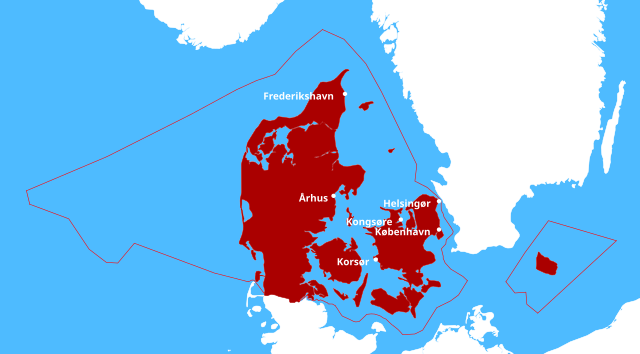
English: Exclusive Economic Zone of Denmark |
| 日期 | |
| 來源 |
own work, based on:
|
| 作者 |
|
| 授權許可 (重用此檔案) |
此檔案採用創用CC 姓名標示-相同方式分享 3.0 未在地化版本授權條款。 姓名標示: rbrausse
|
檔案歷史
點選日期/時間以檢視該時間的檔案版本。
| 日期/時間 | 縮圖 | 尺寸 | 使用者 | 備註 | |
|---|---|---|---|---|---|
| 目前 | 2012年12月3日 (一) 17:49 | | 1,052 × 581(256 KB) | Rbrausse(留言 | 貢獻) | removed one city marker |
| 2012年12月2日 (日) 16:51 |  | 1,052 × 581(257 KB) | Rbrausse(留言 | 貢獻) | changed color | |
| 2012年11月29日 (四) 22:14 |  | 1,052 × 581(257 KB) | Rbrausse(留言 | 貢獻) | different color scheme, changed projection, added some cities | |
| 2012年11月29日 (四) 21:15 |  | 1,052 × 744(209 KB) | Rbrausse(留言 | 貢獻) | {{Information |Description ={{en|1=Exclusive Economic Zone of Denmark}} |Source =own work, based on: * Land and countries: http://www.naturalearthdata.com/downloads/ * Exclusive Economic Zones Boundaries: http://www.marineregions.org/downloa... |
無法覆蓋此檔案。
檔案用途
沒有使用此檔案的頁面。
全域檔案使用狀況
以下其他 wiki 使用了這個檔案:
- de.wikipedia.org 的使用狀況
- en.wikipedia.org 的使用狀況
- fr.wikipedia.org 的使用狀況
- www.wikidata.org 的使用狀況
- zh.wikipedia.org 的使用狀況