File:East entry to Vernal, Utah, on US-40 (7063605801).jpg
跳至導覽
跳至搜尋

預覽大小:800 × 532 像素。 其他解析度:320 × 213 像素 | 640 × 425 像素 | 1,024 × 680 像素 | 1,280 × 850 像素 | 1,600 × 1,063 像素。
原始檔案 (1,600 × 1,063 像素,檔案大小:433 KB,MIME 類型:image/jpeg)
說明
說明
添加單行說明來描述出檔案所代表的內容
摘要
[編輯].jpg&action=edit§ion=1)
| 描述 |
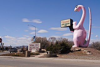
The pink sauropod greets visitors to Vernal, the main population center in northeastern Utah. This is indeed Utah's dinosaur country, because Dinosaur National Monument is only ten miles or so to the east, just north of the town of Jensen. It is also the only reason I decided to drive all the way out here. US-40 was the main east-west highway, also known as the Lincoln Highway, that stretched all the way from San Francisco to Atlantic City. Today, the sections west of Park City have been switched to I-80, but in this area, US-40 still plays an important role as it is still the only direct connection between Salt Lake City and Denver. (I-70 had been intended to supersede US-40 through Utah and Colorado, but I-70 ended up being re-oriented southwest to point toward Las Vegas and Los Angeles instead.) |
| 日期 | 攝於2012年3月15日, 14:07 |
| 來源 | East entry to Vernal, Utah, on US-40 |
| 作者 | InSapphoWeTrust from Los Angeles, California, USA |
| 拍攝地點 | | 位於此地的本圖片與其他圖片: OpenStreetMap |
|---|
.jpg¶ms=040.456237_N_-109.511289_E_globe:Earth_type:camera_source:Flickr_&language=zh-tw)
授權條款
[編輯].jpg&action=edit§ion=2)
此檔案採用創用CC 姓名標示-相同方式分享 2.0 通用版授權條款。
- 您可以自由:
- 分享 – 複製、發佈和傳播本作品
- 重新修改 – 創作演繹作品
- 惟需遵照下列條件:
- 姓名標示 – 您必須指名出正確的製作者,和提供授權條款的連結,以及表示是否有對內容上做出變更。您可以用任何合理的方式來行動,但不得以任何方式表明授權條款是對您許可或是由您所使用。
- 相同方式分享 – 如果您利用本素材進行再混合、轉換或創作,您必須基於如同原先的相同或兼容的條款,來分布您的貢獻成品。
| This image, originally posted to Flickr, was reviewed on 27 January 2013 by the administrator or reviewer File Upload Bot (Magnus Manske), who confirmed that it was available on Flickr under the stated license on that date. |
檔案歷史
點選日期/時間以檢視該時間的檔案版本。
| 日期/時間 | 縮圖 | 尺寸 | 使用者 | 備註 | |
|---|---|---|---|---|---|
| 目前 | 2013年1月27日 (日) 16:04 | | 1,600 × 1,063(433 KB) | File Upload Bot (Magnus Manske)(留言 | 貢獻) | Transferred from Flickr by User:russavia |
無法覆蓋此檔案。
檔案用途
下列2個頁面有用到此檔案:
全域檔案使用狀況
以下其他 wiki 使用了這個檔案:
- ar.wikipedia.org 的使用狀況
- arz.wikipedia.org 的使用狀況
- azb.wikipedia.org 的使用狀況
- be-tarask.wikipedia.org 的使用狀況
- be.wikipedia.org 的使用狀況
- bg.wikipedia.org 的使用狀況
- ca.wikipedia.org 的使用狀況
- ceb.wikipedia.org 的使用狀況
- ce.wikipedia.org 的使用狀況
- cy.wikipedia.org 的使用狀況
- dag.wikipedia.org 的使用狀況
- en.wikipedia.org 的使用狀況
- en.wikivoyage.org 的使用狀況
- es.wikipedia.org 的使用狀況
- eu.wikipedia.org 的使用狀況
- fr.wikipedia.org 的使用狀況
- he.wikipedia.org 的使用狀況
- ht.wikipedia.org 的使用狀況
- hu.wikipedia.org 的使用狀況
- it.wikipedia.org 的使用狀況
- lld.wikipedia.org 的使用狀況
- pl.wikipedia.org 的使用狀況
- pt.wikipedia.org 的使用狀況
- ru.wikipedia.org 的使用狀況
- sr.wikipedia.org 的使用狀況
- sv.wikipedia.org 的使用狀況
- tr.wikipedia.org 的使用狀況
- tt.wikipedia.org 的使用狀況
- uk.wikipedia.org 的使用狀況
- uz.wikipedia.org 的使用狀況
- www.wikidata.org 的使用狀況
- zh-min-nan.wikipedia.org 的使用狀況
- zh.wikipedia.org 的使用狀況
.jpg&oldid=874830101)