File:Elam Map.jpg
Pumunta sa nabigasyon
Pumunta sa paghahanap
Wala na'ng mas malinaw.
Elam_Map.jpg (300 × 250 na pixel, laki: 28 KB, uri ng MIME: image/jpeg)
Captions
Captions
Add a one-line explanation of what this file represents
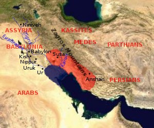
Map of Elam (approximate extension of the Elamite Empire is shown in red, the size of the Persian Gulf in the Bronze Age is indicated in blue (violet?))

|
Pinapayagan ang pagkopya, pamamahagi, at/o pagbabago sa dokumentong ito sa ilalim ng mga nakasaad sa GNU Free Documentation License, Bersyon 1.2 o kahit anong mas bagong bersyong nilathala ng Free Software Foundation; nang walang pabago-bagong bahagi, walang teksto sa front-cover, at walang teksto sa back-cover. May nakalagay na kopya ng lisensiya sa bahaging pinamagatang GNU Free Documentation License. |
| Lisensyado ang file na ito sa ilalim ng lisensiyang Creative Commons Attribution-Share Alike 3.0 Unported. | ||
| ||
| Ang tatak ng paglilisensiya ay idinagdag sa talaksang ito bilang bahagi ng pagsasapanahon ng paglilinsensiya ng GFDL . |
by en:User:Dbachmann, based on [1] archive copy at the Wayback Machine, [2] archive copy at the Wayback Machine.


![[1]](http://www.zoroastriankids.com/map_elam.gif)
![[2]](http://home.columbus.rr.com/malyan/Resources/mesoiranmap.gif)
Nakaraan ng file
Pindutin ang isang petsa/oras para makita ang file noong puntong yon.
| Petsa/Oras | Thumbnail | Sukat | Tagagamit | Komento | |
|---|---|---|---|---|---|
| ngayon | 09:01, 28 Hulyo 2005 | | 300 × 250 (28 KB) | Dbachmann (usapan | ambag) | update |
| 08:18, 26 Hulyo 2005 |  | 300 × 250 (23 KB) | Dbachmann (usapan | ambag) | Map of Elam {{GFDL}} by en:User:Dbachmann, based on [http://www.zoroastriankids.com/map_elam.gif], [http://home.columbus.rr.com/malyan/Resources/mesoiranmap.gif]. |
Hindi mo mao-overwrite ang file na ito.
Paggamit sa file
Ginagamit ng sumusunod na pahina ang file na ito:
Pandaigdigang paggamit sa file
Ginagamit ng mga sumusunod na wiki ang file na ito:
- Paggamit sa af.wikipedia.org
- Paggamit sa am.wikipedia.org
- Paggamit sa ar.wikipedia.org
- Paggamit sa av.wikipedia.org
- Paggamit sa azb.wikipedia.org
- Paggamit sa ba.wikipedia.org
- Paggamit sa bg.wikipedia.org
- Paggamit sa bn.wikipedia.org
- Paggamit sa ca.wikipedia.org
- Paggamit sa ckb.wikipedia.org
- Paggamit sa cv.wikipedia.org
- Paggamit sa da.wikipedia.org
- Paggamit sa de.wikipedia.org
- Paggamit sa diq.wikipedia.org
- Paggamit sa el.wikipedia.org
- Paggamit sa en.wikipedia.org
- Paggamit sa es.wikipedia.org
- Paggamit sa et.wikipedia.org
- Paggamit sa eu.wikipedia.org
- Paggamit sa fa.wikipedia.org
- Paggamit sa fi.wikibooks.org
- Paggamit sa fr.wikipedia.org
- Paggamit sa gl.wikipedia.org
- Paggamit sa he.wikipedia.org
- Paggamit sa hi.wikipedia.org
- Paggamit sa hr.wikipedia.org
- Paggamit sa hu.wikipedia.org
Tingnan ang karagdagang pandaigdigang paggamit sa file na ito.