File:ElectoralCollege1789.svg

Rozmiar pierwotny (Plik SVG, nominalnie 542 × 446 pikseli, rozmiar pliku: 49 KB)
Podpisy
Podpisy
| U.S. presidential election maps (SVG) |
| See also: National Atlas maps (png) |
|
1789 · 1792 · 1796 · 1800 · 1804 · 1808 · 1812 · 1816 · 1820 · 1824 · 1828 · 1832 · 1836 · 1840 · 1844 · 1848 · 1852 · 1856 · 1860 · 1864 · 1868 · 1872 · 1876 · 1880 · 1884 · 1888 · 1892 · 1896 · 1900 · 1904 · 1908 · 1912 · 1916 · 1920 · 1924 · 1928 · 1932 · 1936 · 1940 · 1944 · 1948 · 1952 · 1956 · 1960 · 1964 · 1968 · 1972 · 1976 · 1980 · 1984 · 1988 · 1992 · 1996 · 2000 · 2004 · 2008 · 2012 · 2016 · 2020 · 2024 |
Opis[edytuj]
| Opis |
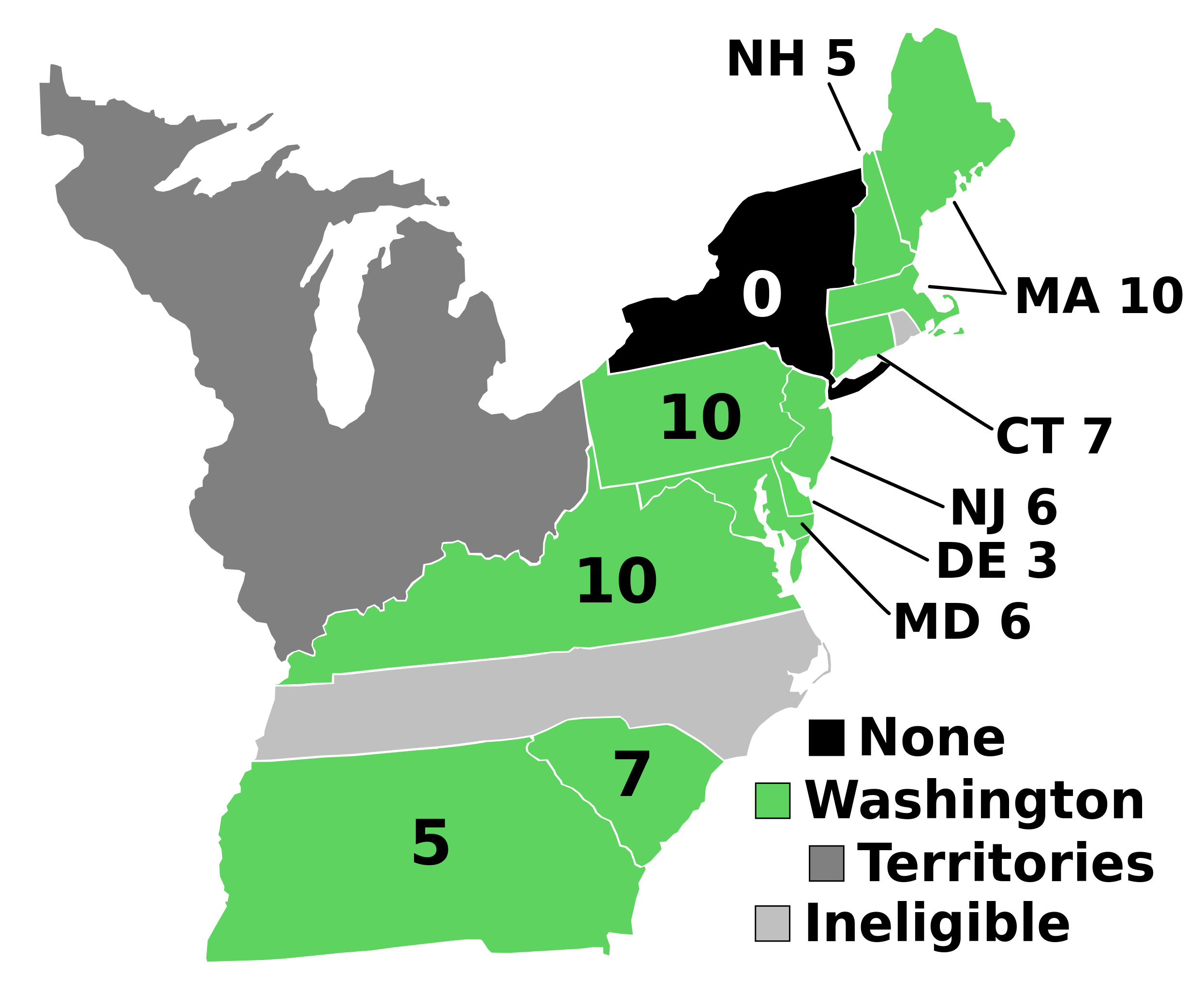
English: Electoral votes by state.
Note: North Carolina and Rhode Island had not yet ratified the Constitution so were therefore ineligible to choose electors. The New York legislature was deadlocked so therefore no electors were chosen. Vermont had been acting independently, but was still considered part of New York at the time. עברית: חלוקת האלקטורים לפי מדינה. |
| Źródło | Praca własna |
| Autor | AndyHogan14 |
| Inne wersje |
Prace pochodne od tego pliku: |
| SVG development | W3C-validity not checked. |
Licencja[edytuj]
| Ja, właściciel praw autorskich do tej pracy, udostępniam ją jako własność publiczną. Dotyczy to całego świata. W niektórych krajach może nie być to prawnie możliwe, jeśli tak, to: Zapewniam każdemu prawo do użycia tej pracy w dowolnym celu, bez żadnych ograniczeń, chyba że te ograniczenia są wymagane przez prawo. |
Historia pliku
Kliknij na odpowiedniej dacie/czasie, aby zobaczyć wersję pliku z tamtego okresu.
| Data/czas | Miniatura | Wymiary | Użytkownik | Opis | |
|---|---|---|---|---|---|
| aktualny | 17:02, 2 wrz 2023 | | 542 × 446 (49 KB) | Clarinetguy097 (dyskusja | edycje) | This should fix the issue with text being cut off. |
| 16:49, 2 wrz 2023 |  | 542 × 446 (49 KB) | Clarinetguy097 (dyskusja | edycje) | I'd instead argue that North Carolina and Rhode Island didn't stop being part of the US when the Constitution went into effect. | |
| 04:40, 29 paź 2021 |  | 542 × 446 (38 KB) | Fluffy89502 (dyskusja | edycje) | NC & RI were not a part of the United States | |
| 04:46, 23 maj 2020 |  | 542 × 446 (40 KB) | Spellcheck (dyskusja | edycje) | Recreated based on 1800 map for consistency Also added legend entry for ineligible states | |
| 06:46, 14 lis 2016 |  | 535 × 437 (35 KB) | Wow (dyskusja | edycje) | New York and font | |
| 04:38, 22 maj 2010 |  | 535 × 437 (29 KB) | Ibagli (dyskusja | edycje) | No DC in 1789 | |
| 19:38, 31 gru 2008 |  | 535 × 437 (28 KB) | AndyHogan14 (dyskusja | edycje) | {{Information |Description= |Source=self-made |Date= |Author= AndyHogan14 |Permission= |other_versions= }} |
Nie możesz nadpisać tego pliku.
Lokalne wykorzystanie pliku
Następujące strony korzystają z tego pliku:
- United States presidential election maps
- User:DaSch/Bot-Export
- User:Magog the Ogre/Political maps/2016 November 11-20
- User:Magog the Ogre/Political maps/2020 May 21-31
- User:Magog the Ogre/Political maps/2021 October 21-31
- User:Magog the Ogre/Political maps/2023 September 1-10
- Category:United States presidential election, 1789
Globalne wykorzystanie pliku
Ten plik jest wykorzystywany także w innych projektach wiki:
- Wykorzystanie na ca.wikipedia.org
- Wykorzystanie na cs.wikipedia.org
- Wykorzystanie na da.wikipedia.org
- Wykorzystanie na de.wikipedia.org
- Wykorzystanie na el.wikipedia.org
- Wykorzystanie na en.wikipedia.org
- 1788–89 United States presidential election
- List of United States presidential election results by state
- United States presidential election
- 1788–89 United States presidential election in Pennsylvania
- 1788–89 United States elections
- 1788–89 United States presidential election in Connecticut
- 1788–89 United States presidential election in Massachusetts
- 1788–89 United States presidential election in New Hampshire
- 1788–89 United States presidential election in New Jersey
- 1788–89 United States presidential election in South Carolina
- 1788–89 United States presidential election in Delaware
- 1788–89 United States presidential election in Georgia
- 1788–89 United States presidential election in Maryland
- 1788–89 United States presidential election in Virginia
- User:Speedicus/sandbox
- Template:State results of the 1788–89 U.S. presidential election
- Electoral history of John Adams
- Wykorzystanie na es.wikipedia.org
- Wykorzystanie na fi.wikipedia.org
- Wykorzystanie na fr.wikipedia.org
- Wykorzystanie na he.wikipedia.org
- Wykorzystanie na it.wikipedia.org
- Wykorzystanie na ja.wikipedia.org
- Wykorzystanie na ko.wikipedia.org
- Wykorzystanie na lt.wikipedia.org
- Wykorzystanie na lv.wikipedia.org
- Wykorzystanie na mk.wikipedia.org
- Wykorzystanie na nl.wikipedia.org
- Wykorzystanie na pl.wikipedia.org
- Wykorzystanie na ru.wikipedia.org
- Wykorzystanie na simple.wikipedia.org
- Wykorzystanie na si.wikipedia.org
- Wykorzystanie na sr.wikipedia.org
- Wykorzystanie na sv.wikipedia.org
- Wykorzystanie na tr.wikipedia.org
- Wykorzystanie na vi.wikipedia.org
- Wykorzystanie na www.wikidata.org
- Wykorzystanie na zh.wikipedia.org