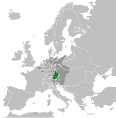
File:Electorate of Bavaria 1789.svg
ნავიგაციაზე გადასვლა
ძიებაზე გადასვლა

ამ SVG ფაილის PNG წინასწარი გადახედვის ზომაა: 450 × 456 პიქსელი. სხვა გაფართოება: 237 × 240 პიქსელი | 474 × 480 პიქსელი | 758 × 768 პიქსელი | 1 011 × 1 024 პიქსელი | 2 021 × 2 048 პიქსელი.
თავდაპირველი ფაილი (ფაილი SVG, ნომინალურად 450 × 456 პიქსელი, ფაილის ზომა: 928 კბ)
Captions
Captions
Add a one-line explanation of what this file represents
რეზიუმე
[რედაქტირება]


.svg)
.svg)
.svg)
.svg)
.svg)


.svg)
.svg)
.svg)


.png)
.png)


.svg)


.svg)

.svg)


.svg)
.svg)
.svg)
.svg)


.svg)
.png)


.svg)


.svg)
.svg)


.svg)


.svg)


.svg)
.svg)
.svg)
.svg)
.svg)
.svg)
.svg)
_cropped.svg)
.svg)
.svg)
.svg)
.svg)
.svg)
.svg)
.svg)
.svg)
.svg)
.svg)
.svg)
.svg)
.svg)
.svg)
.svg)
.svg)
.svg)
.svg)
.svg)
.svg)
.svg)
.svg)
.svg)
.svg)
.svg)
.svg)
.svg)
.svg)
.svg)
.svg)
.svg)
.svg)
.svg)
.svg)
.svg)
.svg)
.svg)
.svg)
.svg)
.svg)
.svg)
.svg)
.svg)
.svg)
.svg)
ლიცენზია
[რედაქტირება]
მე, ამ ნამუშევარზე საავტორო უფლებების მფლობელი, ვაქვეყნებ მას შემდეგი ლიცენზიით:
ეს ნამუშევარი ვრცელდება Creative Commons Attribution-Share Alike 3.0 Unported ლიცენზიით.
- თქვენ თავისუფლად შეგიძლიათ:
- ნამუშევრის გაზიარება – ნამუშევრის კოპირება, გავრცელება და გადაცემა.
- შექმნათ დაფუძნებულები – ნამუშევრის შესწორება
- შემდეგი პირობებით:
- მოხსენიება – თქვენ უნდა მიუთითოთ წყაროს შემქმნელი იმ გზით, რომელიც დანიშნა ავტორმა ან საავტორო უფლებების მფლობელმა. მაგრამ არა ისე, თითქოს წყაროს ავტორი მხარს გიჭერთ თქვენ ან დაუჭირა თქვენს მიერ შექმნილ ნაწარმოებს.
- გავრცელება იგივე პირობებეით – თუ თქვენ ცვლით, ან ქმნით ახალ ნაშრომს ამ ნამუშევრის გამოყენებთ, თქვენ გაქვთ უფლება გაავრცელოთ იგი იგივე ან შესაბამისი ლიცენზიით, რომლითაც ვრცელდება წყარო.
ატვირთვის ჟურნალი
[რედაქტირება]
This image is a derivative work of the following images:
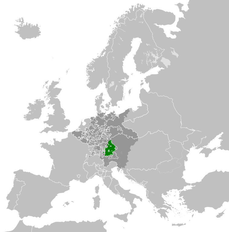
- File:Europe_1789.svg licensed with Cc-by-sa-3.0
- 2013-04-14T03:44:26Z Alphathon 450x456 (858577 Bytes) Corrected some errors in northern Italy
- 2013-04-14T01:38:01Z Alphathon 450x456 (853881 Bytes) tweaked again
- 2013-04-14T01:36:10Z Alphathon 450x456 (853881 Bytes) Tweaked Holy Roman Empire border style
- 2013-04-14T01:33:26Z Alphathon 450x456 (853857 Bytes) == {{int:filedesc}} == {{Information |Description={{en|A blank Map of Europe circa 1789. This map also includes a border for the [[:en:Holy Roman Empire|Holy Roman Empire]]. Since there are so many small German states, they h
Uploaded with derivativeFX
ფაილის ისტორია
დააწკაპუნეთ თარიღზე/დროზე, რათა იხილოთ ფაილი, როგორც ის მაშინ გამოიყურებოდა.
| თარიღი/დრო | მინიატიურა | განზომილებები | მომხმარებელი | კომენტარი | |
|---|---|---|---|---|---|
| მიმდინარე | 07:48, 17 ოქტომბერი 2021 | | 450 × 456 (928 კბ) | Fenn-O-maniC (განხილვა | წვლილი) | Fixed the Russo-Swedish border to match the Treaty of Åbo of 1743 |
| 19:26, 18 აპრილი 2013 |  | 450 × 456 (948 კბ) | Alphathon (განხილვა | წვლილი) | Various fixes and style change | |
| 14:41, 18 აპრილი 2013 |  | 450 × 456 (849 კბ) | Alphathon (განხილვა | წვლილი) | Fixed Scandinavian borders | |
| 16:00, 14 აპრილი 2013 |  | 450 × 456 (834 კბ) | Alphathon (განხილვა | წვლილი) | == {{int:filedesc}} == {{Information |Description={{en|A map of the Electorate of Bavaria circa 1789.}}{{de|Eine Landkarte das Kurfürstentum Bayern c. 1789.}} |Source={{Derived from|Europe_17... |
თქვენ არ შეგიძლიათ ამ ფაილზე გადაწერა.
ფაილის გამოყენება
ეს ფაილი არცერთ გვერდზე არ გამოიყენება.
ფაილის გლობალური გამოყენება
ეს ფაილი გამოიყენება შემდეგ ვიკებში:
- გამოყენება bg.wikipedia.org-ში
- გამოყენება hu.wikipedia.org-ში
- გამოყენება lt.wikipedia.org-ში
- გამოყენება ru.wikipedia.org-ში