File:Emancipation Proclamation.PNG
跳至導覽
跳至搜尋
預覽大小:800 × 520 像素。 其他解析度:320 × 208 像素 | 640 × 416 像素 | 1,024 × 665 像素 | 1,513 × 983 像素。
原始檔案 (1,513 × 983 像素,檔案大小:54 KB,MIME 類型:image/png)
說明
說明
添加單行說明來描述出檔案所代表的內容

|
本圖片是以PNG、GIF或JPEG格式上傳。然而,其中包含的資料或訊息,應該重新建立成可縮放向量圖形(SVG)檔案,以更有效率或更準確的方式儲存。如有可能,請上傳本圖片的SVG格式版本。在上傳之後,請修改維基各姊妹計畫中所有使用舊版圖片的條目(列在圖像連結章節中),替換為新版圖片,並在舊圖片的描述頁中加入{{Vector version available|新圖片名稱.svg}}模板,同時移除本模板。
|
摘要
[編輯]
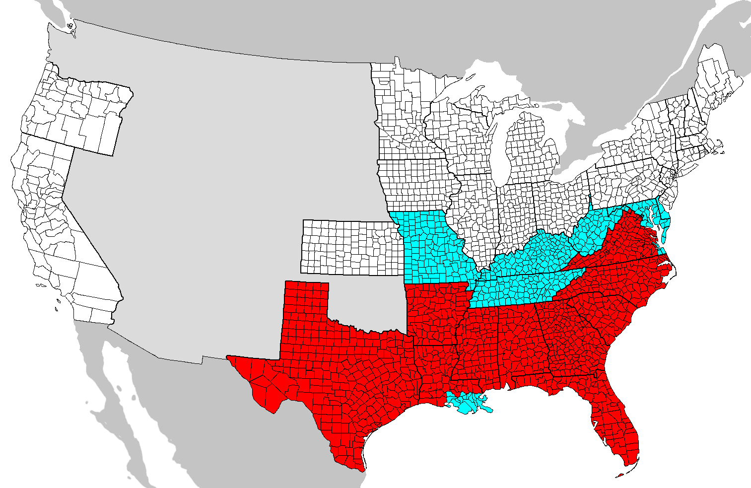
| 描述 | Map of counties covered (red) and not covered (blue) by the Emancipation Proclamation. Map needs updating as these county boundaries reflect modern boundaries and not those during 1862, with some counties displayed on this map not existing at the time. |
| 日期 | (UTC) |
| 來源 | |
| 作者 |
|
| 這是一張修飾過的圖片,即本圖片是用軟體修改過後的版本,修改的方式或內容有:Added colors。原版圖片來源:Map of USA with county outlines.png。修改者:SFGiants。
|

|
已授權您依據自由軟體基金會發行的無固定段落、封面文字和封底文字GNU自由文件授權條款1.2版或任意後續版本,對本檔進行複製、傳播和/或修改。該協議的副本列在GNU自由文件授權條款中。 |
| 此檔案採用創用CC 姓名標示-相同方式分享 3.0 未在地化版本授權條款。 | ||
| ||
| 已新增授權條款標題至此檔案,作為GFDL授權更新的一部份。 |
== 原始上傳日誌 == blue This image is a derivative work of the following images:
- Image:Map_of_USA_with_county_outlines.png licensed with GFDL
- 2008-01-23T04:41:16Z Speight 1513x983 (100713 Bytes) Fix San Francisco Bay and Puget Sound
- 2006-11-23T22:53:51Z Ibagli 1513x983 (169345 Bytes) more fixes
- 2006-11-23T22:53:05Z Ibagli 1513x983 (169416 Bytes) Reverted to earlier revision
- 2006-11-23T22:52:41Z Ibagli 1513x983 (184378 Bytes) more fixes
- 2006-11-23T02:16:28Z Ibagli 1513x983 (169416 Bytes) fix lake St. Clair
- 2005-08-28T20:57:13Z Huhsunqu 1513x983 (169340 Bytes) *{{es}} Mapa de los [[Estados Unidos de América]] mostrando los los límites de estados miembros y sus condados. Versión a colores de la adaptación hecha por [[en:User:Wapcaplet|Wapcaplet]] del mapa de dominio público del
Uploaded with derivativeFX
檔案歷史
點選日期/時間以檢視該時間的檔案版本。
| 日期/時間 | 縮圖 | 尺寸 | 使用者 | 備註 | |
|---|---|---|---|---|---|
| 目前 | 2020年6月14日 (日) 00:46 | | 1,513 × 983(54 KB) | JasonAQuest(留言 | 貢獻) | remove non-states |
| 2008年6月1日 (日) 04:31 |  | 1,513 × 983(171 KB) | SFGiants(留言 | 貢獻) | {{Information |Description=== Summary == Map of counties covered and not covered by the Emancipation Proclamation. |Source=*Image:Map_of_USA_with_county_outlines.png |Date=2008-06-01 04:29 (UTC) |Author=*derivative w |
無法覆蓋此檔案。
檔案用途
下列頁面有用到此檔案:
全域檔案使用狀況
以下其他 wiki 使用了這個檔案:
- cs.wikipedia.org 的使用狀況
- da.wikipedia.org 的使用狀況
- el.wikipedia.org 的使用狀況
- en.wikipedia.org 的使用狀況
- en.wikibooks.org 的使用狀況
- fi.wikipedia.org 的使用狀況
- fr.wikipedia.org 的使用狀況
- he.wikipedia.org 的使用狀況
- it.wikipedia.org 的使用狀況
- ja.wikipedia.org 的使用狀況
- ko.wikipedia.org 的使用狀況
- simple.wikipedia.org 的使用狀況
- sr.wikipedia.org 的使用狀況
- zh.wikipedia.org 的使用狀況