File:EmpireFrench.png
跳至導覽
跳至搜尋

預覽大小:800 × 407 像素。 其他解析度:320 × 163 像素 | 640 × 325 像素 | 1,024 × 521 像素 | 1,280 × 651 像素 | 2,753 × 1,400 像素。
原始檔案 (2,753 × 1,400 像素,檔案大小:193 KB,MIME 類型:image/png)
說明
說明
添加單行說明來描述出檔案所代表的內容
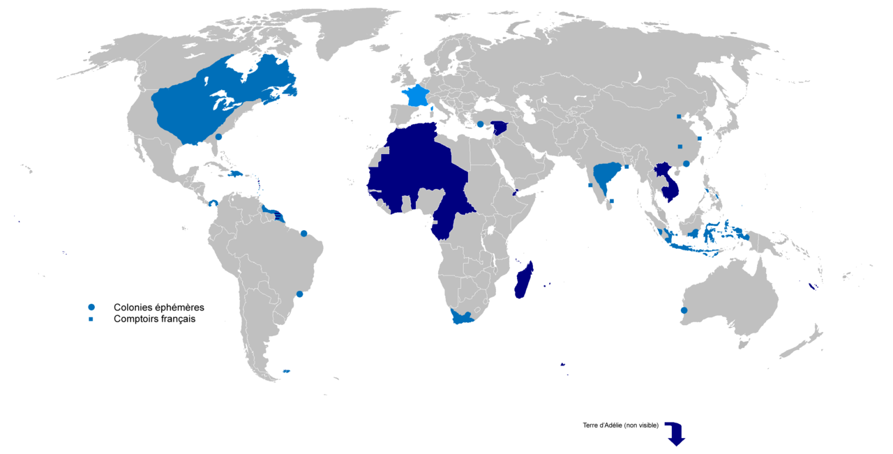
French colonial empires from 1542 to 1980. Light blue: First colonial empire. Dark blue: Second colonial empire.


|
本圖片是以PNG、GIF或JPEG格式上傳。然而,其中包含的資料或訊息,應該重新建立成可縮放向量圖形(SVG)檔案,以更有效率或更準確的方式儲存。如有可能,請上傳本圖片的SVG格式版本。在上傳之後,請修改維基各姊妹計畫中所有使用舊版圖片的條目(列在圖像連結章節中),替換為新版圖片,並在舊圖片的描述頁中加入{{Vector version available|新圖片名稱.svg}}模板,同時移除本模板。
|
摘要
[編輯]
| 描述 |
English: Colonial empire from 1542 to 1980
Dark Blue: Second colonial empire Light Blue: First colonial empire |
| 日期 | 01/06/2010 |
| 來源 | 自己的作品 |
| 作者 | Gd21091993 |
授權條款
[編輯]
| 我,此作品的版權所有人,釋出此作品至公共領域。此授權條款在全世界均適用。 這可能在某些國家不合法,如果是的話: 我授予任何人有權利使用此作品於任何用途,除受法律約束外,不受任何限制。 |
檔案歷史
點選日期/時間以檢視該時間的檔案版本。
| 日期/時間 | 縮圖 | 尺寸 | 用戶 | 備註 | |
|---|---|---|---|---|---|
| 目前 | 2022年4月4日 (一) 17:02 | | 2,753 × 1,400(193 KB) | Oort kuipert(對話 | 貢獻) | added territory in india and america, source : https://commons.wikimedia.org/wiki/File:New_France_(orthographic_projection).svg https://commons.wikimedia.org/wiki/File:French_possessions_in_the_Americas_(1534-1803).png https://commons.wikimedia.org/wiki/File:Evolution_empire.png |
| 2022年3月30日 (三) 15:41 |  | 2,753 × 1,400(194 KB) | Oort kuipert(對話 | 貢獻) | added colonies under Napoléon I according to https://upload.wikimedia.org/wikipedia/commons/3/33/French_Empire_on_World_1812.png | |
| 2017年10月8日 (日) 12:01 |  | 2,753 × 1,400(116 KB) | SUM1(對話 | 貢獻) | Fixes: unshaded Spanish Morocco (Cape Juby), Equatorial Guinea, Nigeria, Southern Cameroons, Zanzibar, Czech border | |
| 2016年3月2日 (三) 13:46 |  | 2,753 × 1,400(99 KB) | Frans45(對話 | 貢獻) | in New Caledonia archipelago only the big island was marked, I added : îles Loayutés, île de Pins, îles Chesterfield | |
| 2010年6月1日 (二) 15:29 |  | 2,753 × 1,400(316 KB) | Gd21091993(對話 | 貢獻) | {{Information |Description={{fr|1=Carte de l'Empire Colonial Français de 1542 à 1980 }} |Source={{own}} |Author=Gd21091993 |Date=01/06/2010 |Permission= |other_versions= }} |
無法覆蓋此檔案。
檔案用途
下列3個頁面有用到此檔案:
全域檔案使用狀況
以下其他 wiki 使用了這個檔案:
- ar.wikipedia.org 的使用狀況
- ast.wikipedia.org 的使用狀況
- azb.wikipedia.org 的使用狀況
- bg.wikipedia.org 的使用狀況
- br.wikipedia.org 的使用狀況
- ca.wikipedia.org 的使用狀況
- cs.wikipedia.org 的使用狀況
- el.wikipedia.org 的使用狀況
- en.wikipedia.org 的使用狀況
- Empire
- User:Dimadick
- French colonial flags
- Analysis of European colonialism and colonization
- Evolution of the French colonial empire
- Political history of the world
- User:Jethwarp
- Timeline of European imperialism
- List of modern great powers
- User:Jethwarp/UBX/French Colonial empire
- Category:Wikipedians interested in European colonial empires
- Liberation of France
- Honor killings by region
- User:Falcaorib/France
- en.wikibooks.org 的使用狀況
- en.wikiquote.org 的使用狀況
- en.wiktionary.org 的使用狀況
- eo.wikipedia.org 的使用狀況
- es.wikipedia.org 的使用狀況
- eu.wikipedia.org 的使用狀況
- fa.wikipedia.org 的使用狀況
- fi.wikipedia.org 的使用狀況
- fr.wikipedia.org 的使用狀況
- fr.wiktionary.org 的使用狀況
- gl.wikipedia.org 的使用狀況
檢視此檔案的更多全域使用狀況。