File:Engraving on a mammoth tusk, map, Gravettian, 076872 cropped.jpg
Aller à la navigation
Aller à la recherche

Taille de cet aperçu : 800 × 450 pixels. Autres résolutions : 320 × 180 pixels | 640 × 360 pixels | 1 024 × 576 pixels | 1 280 × 720 pixels | 3 105 × 1 747 pixels.
Fichier d’origine (3 105 × 1 747 pixels, taille du fichier : 1,79 Mio, type MIME : image/jpeg)
Légendes
Légendes
Ajoutez en une ligne la description de ce que représente ce fichier
Description[modifier]
| Description |
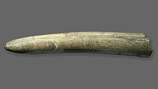
English: Engraving on a mammoth tusk perhaps representing a “map”, Pavlov (Břeclav DIstrict, Southern Moravia, Chech Republic), deposited in ArÚ AVČR Brno. Gravettian. Original. Length 37 cm. Temporary exhibition the Mammoth hunters in the NM Prague. The Pavlovské Hills were created by the arches at top right. In the foothills, the Pavlov settlement appears to have been marked by a circle, while a wavy pattern at the bottom is thought to have symbolized the meanders of the River Dyje. This engraving may well be the oldest known representation of a landscape. Excavation under B. Klíma.
Deutsch: Die 1962 gefundene abgebrochene Spitze eines Mammut-Stoßzahns ist mit einer Gravur versehen, bei der es sich um eine Abbildung der umgebenden Landschaft des Jägerlagers Pavlov I handeln könnte. Die vier verschiedenen Muster dieser stilisierten „ersten Landkarte“ können z. B. als Erosionsrinnen der Pollauer Berge und mäandrierender Flusslauf der Thaya interpretiert werden, der Lagerplatz selbst ist möglicherweise durch zwei konzentrische Kreise dargestellt. |
| Date | |
| Source | File:Engraving_on_a_mammoth_tusk,_map,_Gravettian,_076872.jpg |
| Auteur | User:Zde |
| Autres versions |
 |
Conditions d’utilisation[modifier]
Moi, en tant que détenteur des droits d’auteur sur cette œuvre, je la publie sous la licence suivante :
Ce fichier est sous la licence Creative Commons Attribution – Partage dans les Mêmes Conditions 4.0 International.
- Vous êtes libre :
- de partager – de copier, distribuer et transmettre cette œuvre
- d’adapter – de modifier cette œuvre
- Sous les conditions suivantes :
- paternité – Vous devez donner les informations appropriées concernant l'auteur, fournir un lien vers la licence et indiquer si des modifications ont été faites. Vous pouvez faire cela par tout moyen raisonnable, mais en aucune façon suggérant que l’auteur vous soutient ou approuve l’utilisation que vous en faites.
- partage à l’identique – Si vous modifiez, transformez, ou vous basez sur cette œuvre, vous devez distribuer votre contribution sous la même licence ou une licence compatible avec celle de l’original.
Historique du fichier
Cliquer sur une date et heure pour voir le fichier tel qu'il était à ce moment-là.
| Date et heure | Vignette | Dimensions | Utilisateur | Commentaire | |
|---|---|---|---|---|---|
| actuel | 23 juin 2019 à 08:28 | | 3 105 × 1 747 (1,79 Mio) | Thilo Parg (d | contributions) | {{Information |description ={{en|1=Engraving on a mammoth tusk perhaps representing a “map”, Pavlov (Břeclav DIstrict, Southern Moravia, Chech Republic), deposited in ArÚ AVČR Brno. Gravettian. Original. Length 37 cm. Temporary exhibition the Mammoth hunters in the NM Prague. The Pavlovské Hills were created by the arches at top right. In the foothills, the Pavlov settlement appears to have been marked by a circle, while a wavy pattern at the bottom is thought to have symbolized the meander... |
Vous ne pouvez pas remplacer ce fichier.
Utilisations locales du fichier
Aucune page n’utilise ce fichier.
Utilisations du fichier sur d’autres wikis
Les autres wikis suivants utilisent ce fichier :
- Utilisation sur de.wikipedia.org
- Utilisation sur en.wikipedia.org
- Utilisation sur fr.wikipedia.org