File:Essequiborivermap.png
跳至導覽
跳至搜尋

預覽大小:600 × 600 像素。 其他解析度:240 × 240 像素 | 480 × 480 像素 | 1,000 × 1,000 像素。
原始檔案 (1,000 × 1,000 像素,檔案大小:1.41 MB,MIME 類型:image/png)
說明
說明
添加單行說明來描述出檔案所代表的內容
摘要[編輯]
| 描述 |
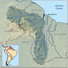
English: This is a map of the Essequibo River drainage basin. |
| 日期 | |
| 來源 | 自己的作品 using Digital Chart of the World and GTOPO data. |
| 作者 | Kmusser |
| 其他版本 | Derivative works of this file: Guayana Esequiba (zonas).png |
.png)
授權條款[編輯]
我,本作品的著作權持有者,決定用以下授權條款發佈本作品:
此檔案採用共享創意 姓名標示-相同方式分享 3.0 未在地化版本授權條款。
- 您可以自由:
- 分享 – 複製、發佈和傳播本作品
- 重新修改 – 創作演繹作品
- 惟需遵照下列條件:
- 姓名標示 – 您必須指名出正確的製作者,和提供授權條款的連結,以及表示是否有對內容上做出變更。您可以用任何合理的方式來行動,但不得以任何方式表明授權條款是對您許可或是由您所使用。
- 相同方式分享 – 如果您利用本素材進行再混合、轉換或創作,您必須基於如同原先的相同或兼容的條款,來分布您的貢獻成品。
檔案歷史
點選日期/時間以檢視該時間的檔案版本。
| 日期/時間 | 縮圖 | 尺寸 | 用戶 | 備註 | |
|---|---|---|---|---|---|
| 目前 | 2023年5月30日 (二) 19:43 | | 1,000 × 1,000(1.41 MB) | Usedbook(對話 | 貢獻) | Reverted to Kmusser (7 April 2010) due to possible vandalism. SurinameCentral erased Guyana's borders in the miniature map of South America. This was clearly not the intention of the original author. |
| 2023年4月1日 (六) 17:40 |  | 1,000 × 1,000(1.4 MB) | SurinameCentral(對話 | 貢獻) | Borders Changed to Disputed Lines, Border river mouth Corantijn corrected. the entire river is the territory of Suriname. | |
| 2010年4月7日 (三) 17:53 |  | 1,000 × 1,000(1.41 MB) | Kmusser(對話 | 貢獻) | Added topology (source: SRTM) | |
| 2008年9月11日 (四) 17:15 |  | 1,000 × 1,000(336 KB) | Kmusser(對話 | 貢獻) | {{Information |Description=This is a map of the Essequibo River drainage basin. |Source=Own work using http://www.maproom.psu.edu/dcw/ Digital Chart of the World and [[http://edc.usgs.gov/products/elevation/gtopo30/gtopo30.html |
無法覆蓋此檔案。
檔案用途
下列3個頁面有用到此檔案:
.png)
全域檔案使用狀況
以下其他 wiki 使用了這個檔案:
- af.wikipedia.org 的使用狀況
- az.wikipedia.org 的使用狀況
- be.wikipedia.org 的使用狀況
- bg.wikipedia.org 的使用狀況
- bn.wikipedia.org 的使用狀況
- ca.wikipedia.org 的使用狀況
- ceb.wikipedia.org 的使用狀況
- cs.wikipedia.org 的使用狀況
- da.wikipedia.org 的使用狀況
- de.wikipedia.org 的使用狀況
- en.wikipedia.org 的使用狀況
- Geography of Guyana
- Essequibo River
- Cuyuní River
- Rupununi
- User:Kmusser
- User:Kmusser/Images
- Mazaruni River
- Hogg Island, Guyana
- Guyana–Venezuela territorial dispute
- Talk:Guyana–Venezuela territorial dispute
- Guyana
- List of rivers of Guyana
- Wenamu River
- Rewa River (Guyana)
- Wikipedia:WikiProject Rivers/Maps
- User:Ivan Mangal/sandbox
- User:Alejitao123/sandbox/Copy-edit/Guyana-Venezuela Dispute
- es.wikipedia.org 的使用狀況
檢視此檔案的更多全域使用狀況。