File:Ethnographic map of hungary 1910 by teleki carte rouge.jpg
Fitxer original (4.962 × 3.509 píxels, mida del fitxer: 5,18 Mo, tipus MIME: image/jpeg)
Llegendes
Llegendes
Resum[modifica]
| Descripció |
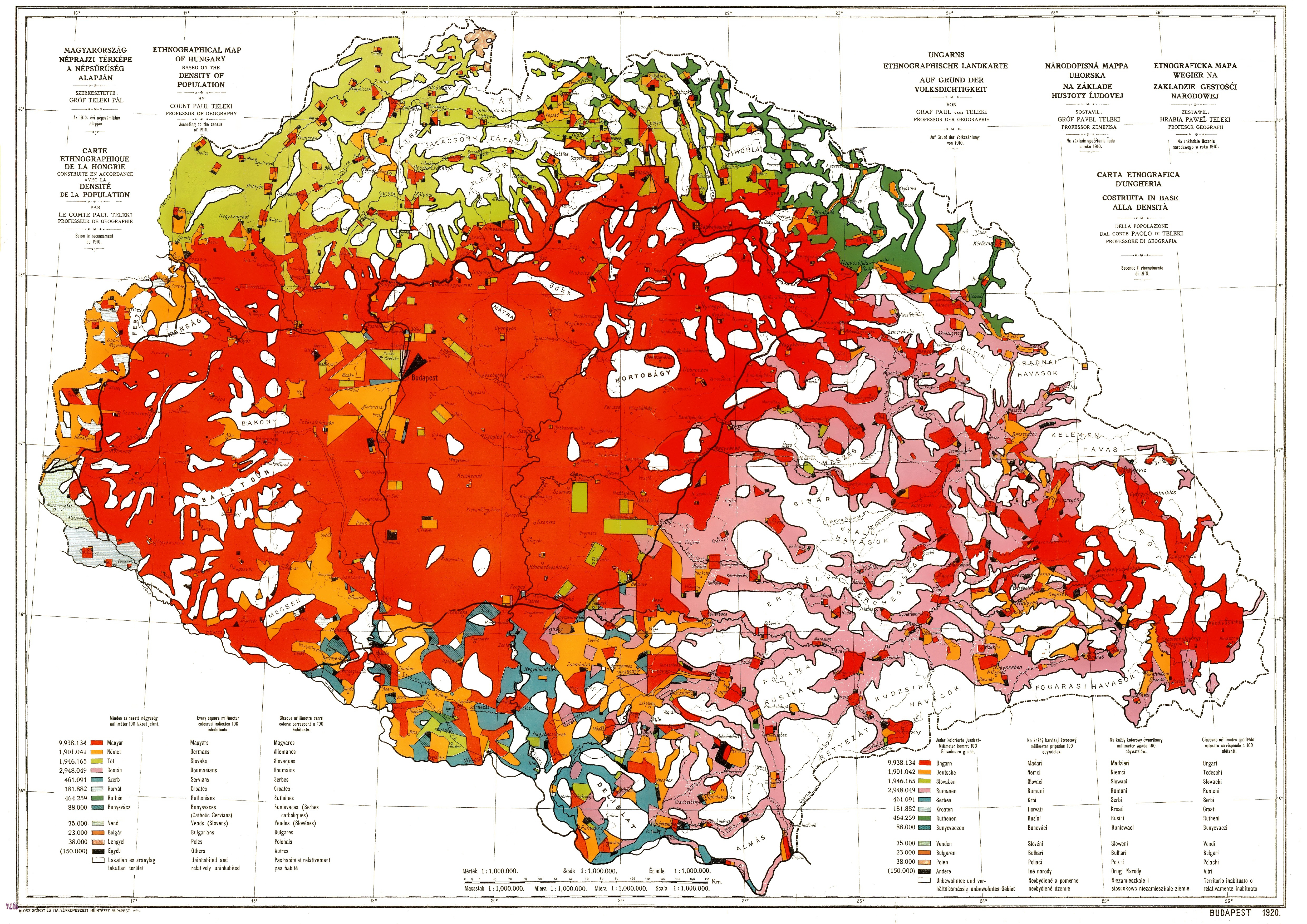
English: Ethnographic map of Hungary, based on the density of population according to the census of 1910. Original scale 1 : 1 000 000. Every square millimeter colored indicates 100 inhabitants. "Carte Rouge" - "Red map" was made for the peace talk in Trianon.
Magyar: Magyarország etnikai térképe az 1910-es népszámlálás adatai alapján. Eredeti méretaránya 1 : 1 000 000. Minden négyzetmilliméter 100 lakost jelent. "Carete Rouge" - Vörös Térkép az 1920-as trianoni béketárgyalásokra készült. Teleki Pál 1918-ban Magyarország néprajzi térképe a népsűrűség alapján című műve szerkesztésénél egy módszertani újdonsággal jelentkezett. Az 1910-es népszámlálás alapján szerkesztett 1:1 milliós térképén arra törekedett, hogy a nemzetiség számaránya és a lakott területük aránya közötti viszonyt megjelenítse, hogy így a népsűrűség is kitűnjék a lakatlanul maradt terület nagyságából. Térképén minden járás területéből csak annyi mm2 térképi felületet töltött ki az ott élő nemzetiségek színével, ahány száz fő élt ott. Tehát térképén minden mm2 száz lakost jelent. Ahol a népsűrűség nem érte el a száz főt, ott bizonyos nagyságú terület fehéren, azaz lakatlanul maradt. Így jól kitűnik például a hegyvidékek ritka lakossága. Viszont ahol meghaladja a száz fő/km2 értéket a népsűrűség, például a városokban, ott a lakosságszám nem fér bele a település térképi vonatkozási felületébe. Teleki ezt a problémát úgy oldotta meg, hogy a népesség számát mértani idomokba rendezve helyezte el a város körül, azaz nem mindenütt jelenik meg a lakosság pontosan azon a területen, ahol a valóságban él. Mivel nem pontos helyén van minden nemzetiséget jelölő színfolt, ezért inkább csak kartogramnak tekinthetjük a művet. Néprajzi határok kijelölésére tehát nem alkalmas, de az ország vagy egyes részei igazságos és valóságos nemzetiségi térképének megítélésére nagyszerűen megfelel, mert egyetlen nemzetiség sem kapott arányán felüli vagy aluli színfoltot. A munka, amely tizenkét színnel jeleníti meg a nemzetiségek képét, számos kiadást ért meg. Megjelent magyar, német, francia és angol szöveggel is, és ez volt az egyetlen térkép, amelyet az 1920-as párizsi béketárgyaláson megtekintettek. Ott kapta a nevét is a magyar nemzetiséget jelölő színről: Carte rouge. |
|||||||||||||||||||||||
| Data | ||||||||||||||||||||||||
| Font | Scanned from an original | |||||||||||||||||||||||
| Autor |
|
|||||||||||||||||||||||

Llicència[modifica]
|
Aquest material està en domini públic als Estats Units i als altres països on el dret d'autor s'estén per 70 anys (o menys) després de la mort de l'autor.
| |
| Aquest fitxer està identificat com a lliure de restriccions conegudes sota la llei de drets d'autor, inclosos els drets veïns. | |
Historial del fitxer
Cliqueu una data/hora per veure el fitxer tal com era aleshores.
| Data/hora | Miniatura | Dimensions | Usuari/a | Comentari | |
|---|---|---|---|---|---|
| actual | 16:46, 22 gen 2016 | | 4.962 × 3.509 (5,18 Mo) | Qorilla (discussió | contribucions) | removed some noise, dots, smears |
| 18:32, 28 des 2009 |  | 4.962 × 3.509 (4,6 Mo) | Qorilla (discussió | contribucions) | whitening and other improvements | |
| 13:57, 2 des 2009 |  | 4.962 × 3.509 (3,11 Mo) | Bercess (discussió | contribucions) | {{Information |Description={{en|1=Ethnographic map of Hungary, based on the density of population according to the census of 1910. Original scale 1 : 1 000 000. Every square millimeter colored indicates 100 inhabitants. "Carte Rouge" - "Red map" was made |
No podeu sobreescriure aquest fitxer.
Ús del fitxer
Les 5 pàgines següents utilitzen aquest fitxer:
Ús global del fitxer
Utilització d'aquest fitxer en altres wikis:
- Utilització a ast.wikipedia.org
- Utilització a azb.wikipedia.org
- Utilització a bn.wikipedia.org
- Utilització a ca.wikipedia.org
- Utilització a cs.wikipedia.org
- Utilització a cy.wikipedia.org
- Utilització a de.wikipedia.org
- Utilització a el.wikipedia.org
- Utilització a en.wikipedia.org
- Utilització a es.wikipedia.org
- Utilització a et.wikipedia.org
- Utilització a fa.wikipedia.org
- Utilització a fi.wikipedia.org
- Utilització a fr.wikipedia.org
- Utilització a hr.wikipedia.org
- Utilització a hu.wikipedia.org
- Utilització a id.wikipedia.org
- Utilització a ko.wikipedia.org
- Utilització a la.wikipedia.org
- Utilització a pl.wikipedia.org
- Utilització a sl.wikipedia.org
- Utilització a sr.wikipedia.org
- Utilització a tr.wikipedia.org
- Utilització a uk.wikipedia.org
Metadades
- Historical maps of ethnic groups in Hungary
- Historical maps of ethnic groups in Romania
- Historical maps of ethnic groups in Transylvania
- Historical maps of ethnic groups in Serbia
- Historical maps of ethnic groups in Vojvodina
- Historical maps of ethnic groups in Croatia
- Historical maps of ethnic groups in Slovenia
- Historical maps of ethnic groups in Austria
- Historical maps of ethnic groups in Slovakia
- Historical maps of ethnic groups in Ukraine
- Maps of the Treaty of Trianon
- Pál Teleki