File:Etolin Strait.PNG
Naviqasiyaya keç
Axtarışa keç

Sınaq göstərişi ölçüsü: 800 × 478 piksel. Digər ölçülər: 320 × 191 piksel | 640 × 382 piksel | 845 × 505 piksel.
Faylın orijinalı (845 × 505 piksel, fayl həcmi: 731 KB, MIME növü: image/png)
Captions
Captions
Add a one-line explanation of what this file represents
Xülasə
[redaktə]
| İzah |
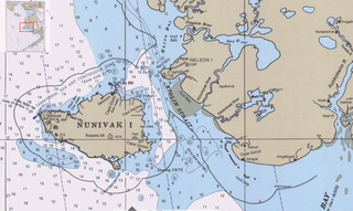
English: Detail of Bering Sea chart showing Etolin Strait and surroundings |
| Tarix | |
| Mənbə | Historical Maps and Charts Project http://historicalcharts.noaa.gov/tiled_jpgs_done/zoomifyURLDrivenWebPage.htm?zoomifyImagePath=16006-12-2000 |
| Müəllif | US NOAA Office of Coast Survey |
Lisenziya
[redaktə]
This image is in the public domain because it contains materials that originally came from the U.S. National Oceanic and Atmospheric Administration, taken or made as part of an employee's official duties.
|
Faylın tarixçəsi
Faylın əvvəlki versiyasını görmək üçün gün/tarix bölməsindəki tarixlərə klikləyin.
| Tarix/Vaxt | Miniatür | Ölçülər | İstifadəçi | Şərh | |
|---|---|---|---|---|---|
| hal-hazırkı | 16:36, 17 sentyabr 2009 | | 845 × 505 (731 KB) | Dankarl (müzakirə | töhfələr) | {{Information |Description={{en|1=Detail of Bering Sea chart showing Etolin Strait and surroundings}} |Source=Historical Maps and Charts Project http://historicalcharts.noaa.gov/tiled_jpgs_done/zoomifyURLDrivenWebPage.htm?zoomifyImagePath=16006-12-2000 | |
Siz bu faylı yenidən yükləyə bilməzsiniz.
Faylın istifadəsi
Bu faylı istifadə edən səhifə yoxdur.
Faylın qlobal istifadəsi
Bu fayl aşağıdakı vikilərdə istifadə olunur:
- ar.wikipedia.org layihəsində istifadəsi
- az.wikipedia.org layihəsində istifadəsi
- ceb.wikipedia.org layihəsində istifadəsi
- el.wikipedia.org layihəsində istifadəsi
- en.wikipedia.org layihəsində istifadəsi
- es.wikipedia.org layihəsində istifadəsi
- fr.wikipedia.org layihəsində istifadəsi
- gl.wikipedia.org layihəsində istifadəsi
- hr.wikipedia.org layihəsində istifadəsi
- incubator.wikimedia.org layihəsində istifadəsi
- it.wikipedia.org layihəsində istifadəsi
- no.wikipedia.org layihəsində istifadəsi
- pl.wikipedia.org layihəsində istifadəsi
- ru.wikipedia.org layihəsində istifadəsi
- uk.wikipedia.org layihəsində istifadəsi
- ur.wikipedia.org layihəsində istifadəsi
- www.wikidata.org layihəsində istifadəsi