File:Eurofighter operators.png
跳至導覽
跳至搜尋

預覽大小:800 × 407 像素。 其他解析度:320 × 163 像素 | 640 × 325 像素 | 1,024 × 521 像素 | 1,280 × 651 像素 | 2,753 × 1,400 像素。
原始檔案 (2,753 × 1,400 像素,檔案大小:126 KB,MIME 類型:image/png)
說明
說明
添加單行說明來描述出檔案所代表的內容
摘要
[編輯]
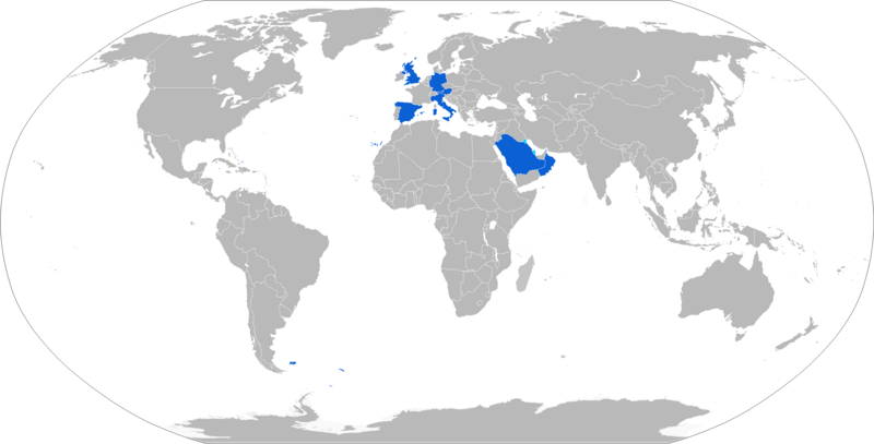
| 描述 | Eurofighter Typhoon operators in blue with orders in cyan. |
| 來源 | wikipedia inglesa / english wikipedia http://en.wikipedia.org/wiki/Image:Eurofighter_operators.png |
| 作者 | Aerobird, then The Bushranger, now Jurryaany. |
授權條款
[編輯]
| 我,此作品的版權所有人,釋出此作品至公共領域。此授權條款在全世界均適用。 這可能在某些國家不合法,如果是的話: 我授予任何人有權利使用此作品於任何用途,除受法律約束外,不受任何限制。 |
檔案歷史
點選日期/時間以檢視該時間的檔案版本。
| 日期/時間 | 縮圖 | 尺寸 | 使用者 | 備註 | |
|---|---|---|---|---|---|
| 目前 | 2017年9月25日 (一) 19:17 | | 2,753 × 1,400(126 KB) | Airwolf(留言 | 貢獻) | Oman received delivery, Qatar commenced oredering process. |
| 2015年10月16日 (五) 13:15 |  | 2,753 × 1,400(91 KB) | Jurryaany(留言 | 貢獻) | Downgraded Oman to ordering | |
| 2015年10月9日 (五) 23:55 |  | 2,753 × 1,400(91 KB) | Jurryaany(留言 | 貢獻) | Updated to new standard format, differentiated between sales and orders. | |
| 2015年9月11日 (五) 20:08 |  | 1,425 × 625(28 KB) | Wrekin762(留言 | 貢獻) | Added Kuwait as a nation "ordering the Eurofighter Typhoon" | |
| 2013年1月29日 (二) 22:51 |  | 1,425 × 625(27 KB) | Wrekin762(留言 | 貢獻) | Added Oman as a nation "ordering the Eurofighter Typhoon" | |
| 2008年1月13日 (日) 07:39 |  | 1,425 × 625(29 KB) | Vinhtantran(留言 | 貢獻) | Full size | |
| 2007年10月12日 (五) 12:03 |  | 400 × 175(29 KB) | Carabás(留言 | 貢獻) | {{Information |Description= Operadores del Eurofighter Typhoon / Operators of the Eurofighter Typhoon. |Source= wikipedia inglesa / english wikipedia http://en.wikipedia.org/wiki/Image:Eurofighter_operators.png |Date= |Author= Aerobird |Permission= |ot |
無法覆蓋此檔案。
檔案用途
下列10個頁面有用到此檔案:
- User:Chumwa/OgreBot/Potential transport maps/2017 September 21-30
- User:Chumwa/OgreBot/Transport Maps/2015 October 1-10
- User:Chumwa/OgreBot/Transport Maps/2015 October 11-20
- User:Chumwa/OgreBot/Transport Maps/2015 September 11-20
- User:Chumwa/OgreBot/Transport Maps/2017 September 21-30
- User:Chumwa/OgreBot/Travel and communication maps/2017 September 21-30
- Commons:WikiProject Aviation/recent uploads/2015 October 16
- Commons:WikiProject Aviation/recent uploads/2015 October 9
- Commons:WikiProject Aviation/recent uploads/2015 September 11
- Commons:WikiProject Aviation/recent uploads/2017 September 25
全域檔案使用狀況
以下其他 wiki 使用了這個檔案:
- ar.wikipedia.org 的使用狀況
- ast.wikipedia.org 的使用狀況
- ca.wikipedia.org 的使用狀況
- de.wikipedia.org 的使用狀況
- en.wikipedia.org 的使用狀況
- es.wikipedia.org 的使用狀況
- fa.wikipedia.org 的使用狀況
- fr.wikipedia.org 的使用狀況
- he.wikipedia.org 的使用狀況
- id.wikipedia.org 的使用狀況
- it.wikipedia.org 的使用狀況
- ja.wikipedia.org 的使用狀況
- ka.wikipedia.org 的使用狀況
- ms.wikipedia.org 的使用狀況
- pl.wikipedia.org 的使用狀況
- sh.wikipedia.org 的使用狀況
- sk.wikipedia.org 的使用狀況
- sr.wikipedia.org 的使用狀況
- sv.wikipedia.org 的使用狀況
- th.wikipedia.org 的使用狀況
- uk.wikipedia.org 的使用狀況
- vi.wikipedia.org 的使用狀況
- zh.wikipedia.org 的使用狀況