File:Europe20000ya.png
ナビゲーションに移動
検索に移動

このプレビューのサイズ: 800 × 532 ピクセル。 その他の解像度: 320 × 213 ピクセル | 640 × 426 ピクセル | 1,024 × 681 ピクセル | 1,280 × 852 ピクセル | 1,900 × 1,264 ピクセル。
元のファイル (1,900 × 1,264 ピクセル、ファイルサイズ: 98キロバイト、MIME タイプ: image/png)
キャプション
キャプション
このファイルの内容を1行で記述してください
概要[編集]
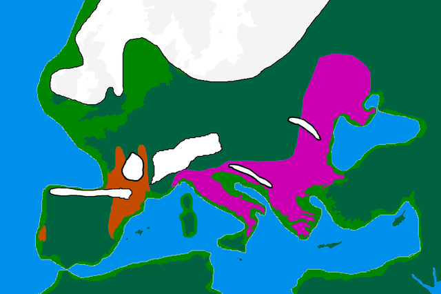
| 解説 | map of Europe 20,000 years ago. |
| 日付 | |
| 原典 |
made by me from Image:BlankMap-Europe-v3.png, which is GFDL v1.2, outline of ancient coast and extent of ice added by me from information from "After the Ice: A Global History" by Steve Mithen. Information about human refugia from "Origins of the British" by Stephen Oppenheimer and "Out of Eden by Stephen Oppenheimer. These were sketched in by me from information supplied by these books. Coloured areas are the furthest extent of the cultures between 15 kya and 20 kya. Solutrean and Proto Solutrean Cultures; Franco-Cantabrian region
Epi Gravettian Culture |
| 作者 | User:Wobble |
| 許可 (ファイルの再利用) |
GFDL |
ライセンス[編集]

|
この文書は、フリーソフトウェア財団発行のGNUフリー文書利用許諾書 (GNU Free Documentation License) 1.2またはそれ以降のバージョンの規約に基づき、複製や再配布、改変が許可されます。不可変更部分、表紙、背表紙はありません。このライセンスの複製は、GNUフリー文書利用許諾書という章に含まれています。 |
| このファイルはクリエイティブ・コモンズ 表示-継承 3.0 非移植ライセンスのもとに利用を許諾されています。 | ||
| ||
| このライセンスのテンプレートは、GFDLのライセンス・アップデートによりこのファイルに追加されたものです。 |
ファイルの履歴
過去の版のファイルを表示するには、その版の日時をクリックしてください。
| 日付と時刻 | サムネイル | 寸法 | 利用者 | コメント | |
|---|---|---|---|---|---|
| 現在の版 | 2007年4月12日 (木) 16:00 | | 1,900 × 1,264 (98キロバイト) | Wobble (トーク | 投稿記録) | Reverted to earlier revision |
| 2007年4月12日 (木) 15:59 |  | 1,000 × 665 (106キロバイト) | Wobble (トーク | 投稿記録) | Reverted to earlier revision | |
| 2007年4月12日 (木) 15:50 |  | 1,900 × 1,264 (98キロバイト) | Wobble (トーク | 投稿記録) | better version, shows refugia better, from Oppenheimer, Out of Eden | |
| 2007年3月28日 (水) 08:13 |  | 1,000 × 665 (106キロバイト) | Dbachmann (トーク | 投稿記録) | shrunk; accounting for Black Sea flood. | |
| 2007年2月25日 (日) 18:59 |  | 1,900 × 1,264 (129キロバイト) | Wobble (トーク | 投稿記録) | {{Information |Description=map of Europe 20,000 years ago. |Source=made from Image:BlankMap-Europe-v3.png, which is GFDL v1.2 by me, outline of coast and extent of ice added by me from information from "After the Ice: A GLoba History" by Steve Mithen. |
このファイルは上書きできません。
ファイルの使用状況
以下の 6 ページがこのファイルを使用しています:
グローバルなファイル使用状況
以下に挙げる他のウィキがこの画像を使っています:
- ar.wikipedia.org での使用状況
- bs.wikipedia.org での使用状況
- ca.wikipedia.org での使用状況
- cs.wikipedia.org での使用状況
- de.wikipedia.org での使用状況
- en.wikipedia.org での使用状況
- Europe
- River Thames
- Upper Paleolithic
- Last Glacial Maximum
- Refugium (population biology)
- User:Swid/Sandbox
- Haplogroup I-M170
- Genetic history of Europe
- Last Glacial Maximum refugia
- User:Hans Adler/Sandbox
- User:Wobble/images
- Cro-Magnon
- Epigravettian
- User:Bongan/genetic history of the human race
- Western Hunter-Gatherer
- User:Baum019/Last Glacial Maximum refugia
- en.wikiversity.org での使用状況
- eo.wikipedia.org での使用状況
- es.wikipedia.org での使用状況
- eu.wikipedia.org での使用状況
- fa.wikipedia.org での使用状況
- fi.wikipedia.org での使用状況
- fr.wikipedia.org での使用状況
このファイルのグローバル使用状況を表示する。