File:Europe 1740 en.png
Ir a la navegación
Ir a la búsqueda

Tamaño de esta previsualización: 800 × 570 píxeles. Otras resoluciones: 320 × 228 píxeles | 640 × 456 píxeles | 1024 × 730 píxeles | 1280 × 913 píxeles | 2560 × 1825 píxeles | 3872 × 2761 píxeles.
Archivo original (3872 × 2761 píxeles; tamaño de archivo: 1,25 MB; tipo MIME: image/png)
Leyendas
Leyendas
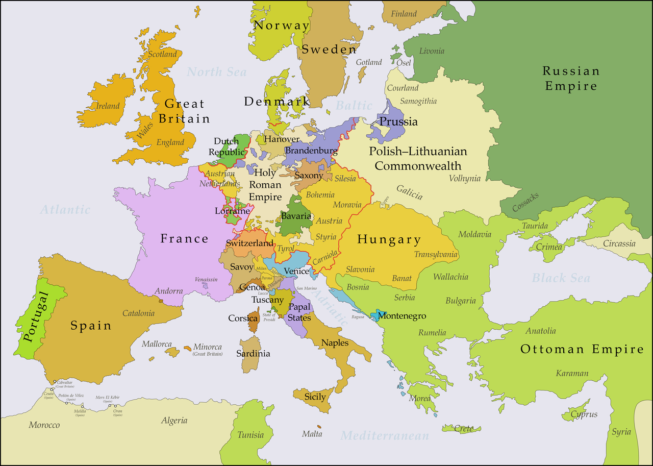
Map showing political borders in Europe between 1739 and 1740
_en.png)
.png)
.jpg)
Resumen[editar]
| Descripción |
English: This map shows Europe in the years between the 1739 Treaty of Belgrade (the end of the Austro–Turkish War (1737–39)) and the beginning of the War of the Austrian Succession in 1740. The red line marks the borders of the Holy Roman Empire. The work was created with Inkscape and is mainly based on a map in: Putzger - Historischer Weltatlas, Berlin 1990, 78 pp. |
| Fecha | |
| Fuente | Trabajo propio, based on File:Europe 1748-1766 en.png |
| Autor | Bryan Rutherford |
Licencia[editar]
Yo, el titular de los derechos de autor de esta obra, la publico en los términos de la siguiente licencia:
Este archivo está disponible bajo la licencia Creative Commons Attribution-Share Alike 4.0 International.
- Eres libre:
- de compartir – de copiar, distribuir y transmitir el trabajo
- de remezclar – de adaptar el trabajo
- Bajo las siguientes condiciones:
- atribución – Debes otorgar el crédito correspondiente, proporcionar un enlace a la licencia e indicar si realizaste algún cambio. Puedes hacerlo de cualquier manera razonable pero no de manera que sugiera que el licenciante te respalda a ti o al uso que hagas del trabajo.
- compartir igual – En caso de mezclar, transformar o modificar este trabajo, deberás distribuir el trabajo resultante bajo la misma licencia o una compatible como el original.
Historial del archivo
Haz clic sobre una fecha y hora para ver el archivo tal como apareció en ese momento.
| Fecha y hora | Miniatura | Dimensiones | Usuario | Comentario | |
|---|---|---|---|---|---|
| actual | 21:49 15 jul 2018 | | 3872 × 2761 (1,25 MB) | Bryanrutherford0 (discusión | contribs.) | Added the Ionian Islands, made the Duchy of Milan a Habsburg possession |
| 02:28 10 jul 2018 |  | 3872 × 2761 (1,25 MB) | Bryanrutherford0 (discusión | contribs.) | Added Comtat Venaissin and redrew borders of Neuchâtel, Bishopric Basel, and Montbéliard | |
| 00:39 3 oct 2017 |  | 3872 × 2761 (1,25 MB) | Bryanrutherford0 (discusión | contribs.) | Transferred control of Saaremaa and Hiiumaa to Russia (1721 Treaty of Nystad) | |
| 12:50 24 ago 2017 |  | 3872 × 2761 (1,25 MB) | Bryanrutherford0 (discusión | contribs.) | Removed Prussian East Frisia (acquired 1744) | |
| 20:17 23 ago 2017 |  | 3872 × 2761 (1,25 MB) | Bryanrutherford0 (discusión | contribs.) | User created page with UploadWizard |
No puedes sobrescribir este archivo.
Usos del archivo
Las siguientes páginas usan este archivo:
Uso global del archivo
Las wikis siguientes utilizan este archivo:
- Uso en azb.wikipedia.org
- Uso en bg.wikipedia.org
- Uso en ca.wikipedia.org
- Uso en cs.wikipedia.org
- Uso en de.wikipedia.org
- Uso en el.wikipedia.org
- Uso en en.wikipedia.org
- Uso en es.wikipedia.org
- Uso en fa.wikipedia.org
- Uso en fi.wikipedia.org
- Uso en fr.wikipedia.org
- Uso en gcr.wikipedia.org
- Uso en he.wikipedia.org
- Uso en id.wikipedia.org
- Uso en it.wikipedia.org
- Uso en ja.wikipedia.org
- Uso en lv.wikipedia.org
- Uso en pt.wikipedia.org
- Uso en ru.wikipedia.org
- Uso en sr.wikipedia.org
- Uso en zh.wikipedia.org