File:Europe before Operation Barbarossa, 1941 (in German).png
Salta a la navegació
Salta a la cerca

Mida d'aquesta previsualització: 575 × 599 píxels. Altres resolucions: 230 × 240 píxels | 461 × 480 píxels | 958 × 998 píxels.
Fitxer original (958 × 998 píxels, mida del fitxer: 142 Ko, tipus MIME: image/png)
Llegendes
Llegendes
Afegeix una explicació d'una línia del que representa aquest fitxer
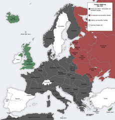
Map showing the Nazi, Finnish and Soviet-controlled borders of Europe by the end of May/beginning of June 1941
Resum
[modifica]| Descripció |
English: Map showing the Nazi, Finnish and Soviet-controlled borders of Europe by the end of May/beginning of June 1941, by the conclusion of the Nazi invasion of the Balkans and before Operation Barbarossa.
This PNG image, with captions in German, is derived from a frame from the GIF animation File:Second world war europe animation large de.gif at Wikimedia Commons. |
| Data | 7 d'abril de 2010 (original upload date) |
| Font | Transferred from en.wikipedia to Commons. |
| Autor |
The original uploader was MaGioZal de la Viquipèdia en anglès.. Later version(s) were uploaded by DIREKTOR at en.wikipedia. |
| Altres versions |
|
.png)
.png&action=edit§ion=1)

|
Aquesta imatge (de tipus military map) s'hauria de tornar a crear utilitzant gràfics vectorials com ara un fitxer SVG. Això té diversos avantatges; en trobareu més informació a Commons:Media for cleanup. Si ja disposeu d'una versió d'aquesta imatge en format SVG, us preguem que la pengeu; després, reemplaceu aquesta plantilla amb la plantilla {{Vector version available|nom nou de la imatge.svg}} en aquesta imatge.
|
Llicència
[modifica].png&action=edit§ion=2)

|
S'autoritza la còpia, la distribució i la modificació d'aquest document sota els termes de la llicència de documentació lliure GNU versió 1.2 o qualsevol altra versió posterior que publiqui la Free Software Foundation; sense seccions invariants, ni textos de portada, ni textos de contraportada. S'inclou una còpia d'aquesta llicència en la secció titulada GNU Free Documentation License. |
| Aquest fitxer està subjecte a la llicència de Creative Commons Reconeixement i Compartir Igual 3.0 No adaptada. | ||
| ||
| Aquest avís de llicència s'ha afegit a aquest fitxer d'acord amb l'actualització de la llicència GFDL. |
Registre original de càrregues
[modifica].png&action=edit§ion=3)
La pàgina de descripció original era aquí. Els noms d'usuari a continuació es refereixen a en.wikipedia.
- 2012-05-22 17:09 DIREKTOR 958×998× (200029 bytes) Colours
- 2010-04-07 01:43 MaGioZal 960×1000× (149500 bytes) Map showing the Nazi (darker blue) and Soviet-controlled (green) borders of Europe by the end of May/beginning of June [[1941]], after the [[Balkans Campaign|Nazi invasion of the Balkans]] and before [[Operation Barbarossa]]. This [[PNG image]], with cap
Historial del fitxer
Cliqueu una data/hora per veure el fitxer tal com era aleshores.
| Data/hora | Miniatura | Dimensions | Usuari/a | Comentari | |
|---|---|---|---|---|---|
| actual | 18:13, 7 set 2012 | | 958 × 998 (142 Ko) | Illythr (discussió | contribucions) | Removed the "changes in the last frame" coloring, as there's only one frame here and the legend was misleading. |
| 02:09, 16 ago 2012 |  | 958 × 998 (195 Ko) | OgreBot (discussió | contribucions) | (BOT): Reverting to most recent version before archival | |
| 02:09, 16 ago 2012 |  | 960 × 1.000 (146 Ko) | OgreBot (discussió | contribucions) | (BOT): Uploading old version of file from en.wikipedia; originally uploaded on 2010-04-07 01:43:08 by MaGioZal | |
| 20:04, 22 juny 2012 |  | 958 × 998 (195 Ko) | Friedlibend und tapfer (discussió | contribucions) | {{Information |Description={{en|Map showing the Nazi and Soviet-controlled borders of Europe by the end of May/beginning of June 1941, by the conclusion of the Nazi invasion of the Balkans and before [[:en:Operatio... |
No podeu sobreescriure aquest fitxer.
Ús del fitxer
No hi ha pàgines que utilitzin aquest fitxer.
Ús global del fitxer
Utilització d'aquest fitxer en altres wikis:
- Utilització a af.wikipedia.org
- Utilització a ar.wikipedia.org
- Utilització a ast.wikipedia.org
- Utilització a azb.wikipedia.org
- Utilització a az.wikipedia.org
- Utilització a bg.wikipedia.org
- Utilització a bn.wikipedia.org
- Utilització a br.wikipedia.org
- Utilització a ca.wikipedia.org
- Utilització a cs.wikipedia.org
- Utilització a en.wikipedia.org
- Continuation War
- Molotov–Ribbentrop Pact
- Operation Barbarossa
- Eastern Front (World War II)
- Balkans campaign (World War II)
- Interim Peace
- User:Dead Mary/sandbox6
- User:Dead Mary/sandbox7
- Presidency of Franklin D. Roosevelt, third and fourth terms
- Foreign policy of the Franklin D. Roosevelt administration
- User:Falcaorib/Europe
- User:Falcaorib/Germany and Prussia
- User:Idfklol1/sandbox
- Utilització a eo.wikipedia.org
- Utilització a es.wikipedia.org
- Utilització a fi.wikipedia.org
- Utilització a hy.wikipedia.org
- Utilització a lt.wikipedia.org
- Utilització a lv.wikipedia.org
- Utilització a nl.wikipedia.org
- Utilització a pnb.wikipedia.org
- Utilització a pt.wikipedia.org
- Utilització a ru.wikipedia.org
- Utilització a ta.wikipedia.org
- Utilització a th.wikipedia.org
- Utilització a ur.wikipedia.org
- Utilització a zh.wikipedia.org
.png&oldid=881006856)