File:Europe before Operation Barbarossa, 1941 (in German).png
跳转到导航
跳转到搜索

本预览的尺寸:575 × 599像素。 其他分辨率:230 × 240像素 | 461 × 480像素 | 958 × 998像素。
原始文件 (958 × 998像素,文件大小:142 KB,MIME类型:image/png)
说明
说明
添加一行文字以描述该文件所表现的内容
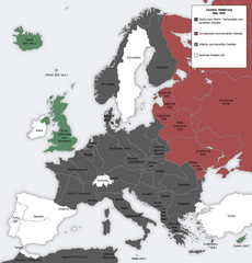
Map showing the Nazi, Finnish and Soviet-controlled borders of Europe by the end of May/beginning of June 1941
摘要
[编辑]| 描述 |
English: Map showing the Nazi, Finnish and Soviet-controlled borders of Europe by the end of May/beginning of June 1941, by the conclusion of the Nazi invasion of the Balkans and before Operation Barbarossa.
This PNG image, with captions in German, is derived from a frame from the GIF animation File:Second world war europe animation large de.gif at Wikimedia Commons. |
| 日期 | 2010年4月7日 (原始上传日期) |
| 来源 | Transferred from en.wikipedia to Commons. |
| 作者 | Later version(s) were uploaded by DIREKTOR at en.wikipedia. |
| 其他版本 |
|
.png)
.png&action=edit§ion=1)

|
此military map图片可使用矢量图形重新创建为SVG文件。这具有很多好处;更多信息请参见共享资源:待清理媒体。如果存在此图片的SVG格式,请将其上传,然后将此模板替换为
{{vector version available|新图片名称}}。
建议您将SVG命名为“Europe before Operation Barbarossa, 1941 (in German).svg”,这样在使用Vector version available(或Vva)模板时就不需要填写新图片名称参数。 |
许可协议
[编辑].png&action=edit§ion=2)

|
已授权您依据自由软件基金会发行的无固定段落及封面封底文字(Invariant Sections, Front-Cover Texts, and Back-Cover Texts)的GNU自由文件许可协议1.2版或任意后续版本的条款,复制、传播和/或修改本文件。该协议的副本请见“GNU Free Documentation License”。 |
| 本文件采用知识共享署名-相同方式共享 3.0 未本地化版本许可协议授权。 | ||
| ||
| 本许可协议标签作为GFDL许可协议更新的组成部分被添加至本文件。 |
原始上传日志
[编辑].png&action=edit§ion=3)
The original description page was here. All following user names refer to en.wikipedia.
- 2012-05-22 17:09 DIREKTOR 958×998× (200029 bytes) Colours
- 2010-04-07 01:43 MaGioZal 960×1000× (149500 bytes) Map showing the Nazi (darker blue) and Soviet-controlled (green) borders of Europe by the end of May/beginning of June [[1941]], after the [[Balkans Campaign|Nazi invasion of the Balkans]] and before [[Operation Barbarossa]]. This [[PNG image]], with cap
文件历史
点击某个日期/时间查看对应时刻的文件。
| 日期/时间 | 缩略图 | 大小 | 用户 | 备注 | |
|---|---|---|---|---|---|
| 当前 | 2012年9月7日 (五) 18:13 | | 958 × 998(142 KB) | Illythr(留言 | 贡献) | Removed the "changes in the last frame" coloring, as there's only one frame here and the legend was misleading. |
| 2012年8月16日 (四) 02:09 |  | 958 × 998(195 KB) | OgreBot(留言 | 贡献) | (BOT): Reverting to most recent version before archival | |
| 2012年8月16日 (四) 02:09 |  | 960 × 1,000(146 KB) | OgreBot(留言 | 贡献) | (BOT): Uploading old version of file from en.wikipedia; originally uploaded on 2010-04-07 01:43:08 by MaGioZal | |
| 2012年6月22日 (五) 20:04 |  | 958 × 998(195 KB) | Friedlibend und tapfer(留言 | 贡献) | {{Information |Description={{en|Map showing the Nazi and Soviet-controlled borders of Europe by the end of May/beginning of June 1941, by the conclusion of the Nazi invasion of the Balkans and before [[:en:Operatio... |
您不可以覆盖此文件。
文件用途
没有页面使用本文件。
全域文件用途
以下其他wiki使用此文件:
- af.wikipedia.org上的用途
- ar.wikipedia.org上的用途
- ast.wikipedia.org上的用途
- azb.wikipedia.org上的用途
- az.wikipedia.org上的用途
- bg.wikipedia.org上的用途
- bn.wikipedia.org上的用途
- br.wikipedia.org上的用途
- ca.wikipedia.org上的用途
- cs.wikipedia.org上的用途
- en.wikipedia.org上的用途
- Continuation War
- Molotov–Ribbentrop Pact
- Operation Barbarossa
- Eastern Front (World War II)
- Balkans campaign (World War II)
- Interim Peace
- User:Dead Mary/sandbox6
- User:Dead Mary/sandbox7
- Presidency of Franklin D. Roosevelt, third and fourth terms
- Foreign policy of the Franklin D. Roosevelt administration
- User:Falcaorib/Europe
- User:Falcaorib/Germany and Prussia
- eo.wikipedia.org上的用途
- es.wikipedia.org上的用途
- fi.wikipedia.org上的用途
- hy.wikipedia.org上的用途
- lt.wikipedia.org上的用途
- lv.wikipedia.org上的用途
- nl.wikipedia.org上的用途
- pnb.wikipedia.org上的用途
- pt.wikipedia.org上的用途
- ru.wikipedia.org上的用途
- ta.wikipedia.org上的用途
- th.wikipedia.org上的用途
- ur.wikipedia.org上的用途
- zh.wikipedia.org上的用途
.png&oldid=881006856)