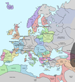
File:Europe in 1345.png
De Wikimedia Commons, el repositorio multimedia libre
Ir a la navegación
Ir a la búsqueda

Tamaño de esta previsualización: 552 × 600 píxeles. Otras resoluciones: 221 × 240 píxeles | 442 × 480 píxeles | 707 × 768 píxeles | 1075 × 1168 píxeles.
Archivo original (1075 × 1168 píxeles; tamaño de archivo: 114 kB; tipo MIME: image/png)
Información del archivo
Datos estructurados
Leyendas
Leyendas
Añade una explicación corta acerca de lo que representa este archivo
Resumen[editar]
| DescripciónEurope in 1345.png | A map of Europe in 1345, showing the location of events that took place in that year. The Black Plague's exact location in unknown, and the shaded area to the right represents rough scholarly estimates. It hit the Crimea in the following year. |
| Fecha | |
| Fuente | self-made from Image:Europein1328.png with GIMP |
| Autor | Teaandcrumpets |

|
Esta imagen debería volverse a crear como imágenes vectoriales SVG. Esto proporciona muchas ventajas, véase Commons:Media for cleanup (en inglés) para más información. Si ya hay una versión SVG de esta imagen disponible, por favor súbala a Commons. Tras subirla, reemplace esta plantilla con la plantilla
{{vector version available|nuevo nombre de imagen.svg}} en esta imagen. |
Licencia[editar]
| Public domainPublic domainfalsefalse |
| Yo, el titular de los derechos de autor de esta obra, lo libero al dominio público. Esto aplica en todo el mundo. En algunos países esto puede no ser legalmente factible; si ello ocurriese: Concedo a cualquier persona el derecho de usar este trabajo para cualquier propósito, sin ningún tipo de condición al menos que éstas sean requeridas por la ley. |
Historial del archivo
Haz clic sobre una fecha y hora para ver el archivo tal como apareció en ese momento.
| Fecha y hora | Miniatura | Dimensiones | Usuario | Comentario | |
|---|---|---|---|---|---|
| actual | 19:31 10 may 2020 |  | 1075 × 1168 (114 kB) | Santasa99 (discusión | contribs.) | Corrections per Euroatlas - Historical Maps, http://www.euratlas.net/history/europe/1300/index.html Euratlas Periodis Web - Map of Europe in Year 1300 |
| 12:58 24 dic 2017 |  | 1075 × 1168 (289 kB) | Trey Kincaid (discusión | contribs.) | Changed Sicily who had his own kingdom | |
| 19:30 1 jul 2012 |  | 1075 × 1168 (282 kB) | Ludde23 (discusión | contribs.) | Changed Estonia from the red color of Sweden to the yellow color of Denmark, since Estonia was not Swedish at this time, but belonged to Denmark until 1346. | |
| 21:34 24 abr 2009 |  | 1075 × 1168 (112 kB) | Alex:D (discusión | contribs.) | Borders corrected | |
| 18:02 15 nov 2007 |  | 1075 × 1168 (110 kB) | Teaandcrumpets (discusión | contribs.) | (changed notre dame marker) | |
| 23:03 13 nov 2007 |  | 1075 × 1168 (113 kB) | Teaandcrumpets (discusión | contribs.) | {{Information |Description= A map of Europe in 1345, showing the location of events that took place in that year. |Source=self-made from Image:Europein1328.png with GIMP |Date= 13 Nov 2007 |Author= Teaandcrumpets |Permission= |
No puedes sobrescribir este archivo.
Usos del archivo
No hay páginas que enlacen a este archivo.
Uso global del archivo
Las wikis siguientes utilizan este archivo:
- Uso en en.wikipedia.org
- Uso en fr.wikipedia.org
- Uso en sl.wikipedia.org
- Uso en smn.wikipedia.org
- Uso en ur.wikipedia.org
Metadatos
Este archivo contiene información adicional, probablemente añadida por la cámara digital o el escáner usado para crearlo o digitalizarlo.
Si el archivo ha sido modificado desde su estado original, pueden haberse perdido algunos detalles.
| Fecha y hora de modificación del archivo | 19:26 10 may 2020 |
|---|---|
| Resolución horizontal | 37,79 dpc |
| Resolución vertical | 37,79 dpc |