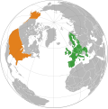
File:European Union United States Locator.svg
来自Wikimedia Commons
跳转到导航
跳转到搜索

此SVG文件的PNG预览的大小:550 × 550像素。 其他分辨率:240 × 240像素 | 480 × 480像素 | 768 × 768像素 | 1,024 × 1,024像素 | 2,048 × 2,048像素。
原始文件 (SVG文件,尺寸为550 × 550像素,文件大小:678 KB)
文件信息
结构化数据
说明
说明
添加一行文字以描述该文件所表现的内容
Map of the globe, highlighting the United States of America and the European Union.
文件历史
点击某个日期/时间查看对应时刻的文件。
| 日期/时间 | 缩略图 | 大小 | 用户 | 备注 | |
|---|---|---|---|---|---|
| 当前 | 2022年1月31日 (一) 23:10 |  | 550 × 550(678 KB) | TorreAzzurro(留言 | 贡献) | Added Cyprus and French Guiana |
| 2020年2月28日 (五) 23:11 |  | 550 × 550(676 KB) | Hogweard(留言 | 贡献) | Update | |
| 2019年10月17日 (四) 08:56 |  | 550 × 550(677 KB) | Ssolbergj(留言 | 贡献) | c | |
| 2019年10月17日 (四) 08:55 |  | 550 × 550(677 KB) | Ssolbergj(留言 | 贡献) | c | |
| 2013年7月2日 (二) 08:45 |  | 638 × 328(1.49 MB) | Treehill(留言 | 贡献) | + croatia (problem on the first upload) | |
| 2013年7月2日 (二) 08:42 |  | 638 × 328(1.49 MB) | Treehill(留言 | 贡献) | + croatia | |
| 2010年7月20日 (二) 15:46 |  | 638 × 328(1.8 MB) | Ssolbergj(留言 | 贡献) | better projection | |
| 2010年5月15日 (六) 00:35 |  | 940 × 415(1.51 MB) | CGN2010(留言 | 贡献) | {{Information |Description=European Union - United States locator map |Source={{own}} |Date=2010-05-15 |Author={{own}} |Permission={{PD-self}} |other_versions= }} Category:Bilateral maps of the European Union [[Category:maps of the United Sta | |
| 2008年5月31日 (六) 13:01 |  | 999 × 553(574 KB) | Ssolbergj(留言 | 贡献) | {{Information |Description= |Source= |Date= |Author= |Permission= |other_versions= }} | |
| 2008年1月5日 (六) 15:17 |  | 940 × 477(1.6 MB) | Ssolbergj(留言 | 贡献) | {{Information |Description=The EU and the US |Source=self-made |Date=05.01.08 |Author= Ssolbergj |Permission= |other_versions= }} |
您不可以覆盖此文件。
文件用途
以下3个页面使用本文件:
全域文件用途
以下其他wiki使用此文件:
- ar.wikipedia.org上的用途
- bg.wikipedia.org上的用途
- ca.wikipedia.org上的用途
- cs.wikipedia.org上的用途
- cy.wikipedia.org上的用途
- da.wikipedia.org上的用途
- de.wikipedia.org上的用途
- en.wikipedia.org上的用途
- eo.wikiquote.org上的用途
- es.wikipedia.org上的用途
- eu.wikipedia.org上的用途
- fa.wikipedia.org上的用途
- fi.wikipedia.org上的用途
- fr.wikipedia.org上的用途
- gl.wikipedia.org上的用途
- hr.wikipedia.org上的用途
- hy.wikipedia.org上的用途
- id.wikipedia.org上的用途
- it.wikipedia.org上的用途
- ja.wikipedia.org上的用途
- ko.wikipedia.org上的用途
- nl.wikipedia.org上的用途
- no.wikipedia.org上的用途
- pl.wikipedia.org上的用途
- ro.wikipedia.org上的用途
- ru.wikipedia.org上的用途
- sv.wikipedia.org上的用途
- tr.wikipedia.org上的用途
- uk.wikipedia.org上的用途
- vi.wikipedia.org上的用途
- www.wikidata.org上的用途
- zh.wikipedia.org上的用途
元数据
此文件含有额外信息,这些信息可能是创建或数字化该文件时使用的数码相机或扫描仪所添加的。如果文件已从其原始状态修改,某些详细信息可能无法完全反映修改后的文件。
| 宽度 | 550.00049 |
|---|---|
| 高度 | 550.00098 |