File:Federal subjects of Russia by population dencity.svg
跳转到导航
跳转到搜索

此SVG文件的PNG预览的大小:800 × 434像素。 其他分辨率:320 × 173像素 | 640 × 347像素 | 1,024 × 555像素 | 1,280 × 694像素 | 2,560 × 1,388像素 | 5,000 × 2,710像素。
原始文件 (SVG文件,尺寸为5,000 × 2,710像素,文件大小:240 KB)
说明
说明
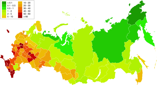
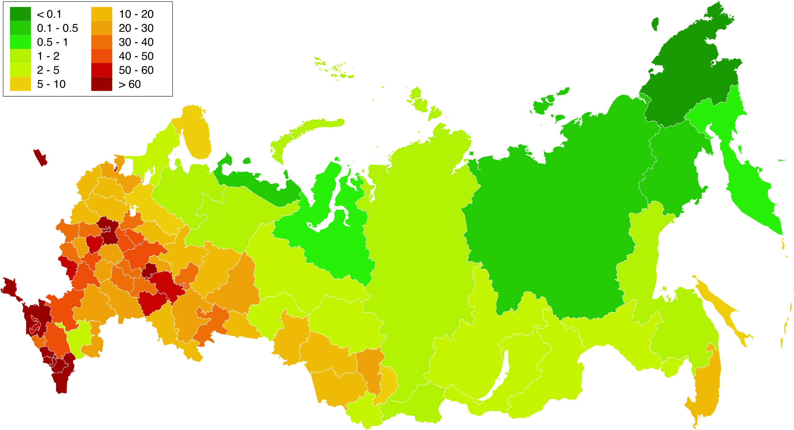
俄罗斯联邦主体人口密度地图。阿尔汉格尔斯克州和秋明州的人口密度与所属各自治州的人口和面积一起计算。
Crimea is Ukraine

|
本地图上显示的边界是实际(de facto)情况。这只是对主题多种观点中的一种(参见COM:NPOV)。 |
摘要
[编辑]| 描述 |
English: Map of population density in the subjects of the Russian Federation. The population density of Arkhangelsk Oblast and Tyumen Oblast was calculated together with the population and area of the respective Autonomous Okrugs belonging to them.
Русский: Карта плотности населения в субъектах Российской Федерации. При расчёте плотностей населения Архангельской и Тюменской области учитывались площади и населения входящих в них автономных округов.
中文:俄罗斯联邦主体人口密度地图。阿尔汉格尔斯克州和秋明州的人口密度与所属各自治州的人口和面积一起计算。 |
| 日期 | 1.02.2010 20:39:08 MSK |
| 来源 | Russia - blank map (2009-01).svg |
| 作者 | 自己的作品. Original uploader was Алексей Глушков at ru.wikipedia |
| 其他版本 |
Other views related to this image
|

.svg)
许可协议
[编辑]
| 我,本作品著作权人,释出本作品至公有领域。这适用于全世界。 在一些国家这可能不合法;如果是这样的话,那么: 我无条件地授予任何人以任何目的使用本作品的权利,除非这些条件是法律规定所必需的。 |
文件历史
点击某个日期/时间查看对应时刻的文件。
| 日期/时间 | 缩略图 | 大小 | 用户 | 备注 | |
|---|---|---|---|---|---|
| 当前 | 2019年3月20日 (三) 16:58 | | 5,000 × 2,710(240 KB) | Gajmar(留言 | 贡献) | Kaluga Oblast |
| 2019年3月19日 (二) 20:46 |  | 5,000 × 2,710(240 KB) | Gajmar(留言 | 贡献) | new colour scheme | |
| 2019年3月19日 (二) 20:17 |  | 5,000 × 2,710(236 KB) | Gajmar(留言 | 贡献) | update (01.01.2019) | |
| 2013年3月3日 (日) 15:39 |  | 1,650 × 1,000(141 KB) | Gajmar(留言 | 贡献) | 1.01.2013 | |
| 2011年5月28日 (六) 16:53 |  | 1,650 × 1,000(140 KB) | Gajmar(留言 | 贡献) | Update the data according to Russian census of 2010 (as of October 14). Indications of population density changed in Karachay-Cherkess Republic, Republic of Mari El, Leningrad Oblast and the Jewish Autonomous Oblast. / Обновление данных с | |
| 2010年2月1日 (一) 18:22 |  | 1,650 × 1,000(109 KB) | Алексей Глушков(留言 | 贡献) | {{Information |Description={{en|1=Population density map in subjects of the Russian Federation. At calculation of population density Arkhangelsk and the Tyumen region the areas and the population of autonomous regions entering into them were considered.}} |
您不可以覆盖此文件。
文件用途
以下2个页面使用本文件:
全域文件用途
以下其他wiki使用此文件:
- af.wikipedia.org上的用途
- ar.wikipedia.org上的用途
- az.wikipedia.org上的用途
- bg.wikipedia.org上的用途
- de.wikipedia.org上的用途
- es.wikipedia.org上的用途
- eu.wikipedia.org上的用途
- fa.wikipedia.org上的用途
- hu.wikipedia.org上的用途
- kk.wikipedia.org上的用途
- pnb.wikipedia.org上的用途
- ps.wikipedia.org上的用途
- ru.wikipedia.org上的用途
- te.wikipedia.org上的用途
- zh.wikipedia.org上的用途