File:First Eblaite Empire.png
Aller à la navigation
Aller à la recherche

Taille de cet aperçu : 800 × 508 pixels. Autres résolutions : 320 × 203 pixels | 640 × 407 pixels | 1 024 × 650 pixels | 1 324 × 841 pixels.
Fichier d’origine (1 324 × 841 pixels, taille du fichier : 1,29 Mio, type MIME : image/png)
Légendes
Légendes
Ajoutez en une ligne la description de ce que représente ce fichier
Description
[modifier]
| Description |
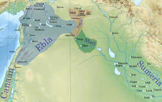
English: Ebla' first kingdom at its height c. 2340 BC.
The first Eblaite kingdom extended from Urshu in the north,1 to Damascus area in the south.2 And from Phoenicia and the coastal mountains in the west,3 4 to Tuttul,5 and Haddu in the east.6 The eastern kingdom of Nagar controlled most of the Khabur basin from the river junction with the Euphrates to the northwestern part at Nabada.7 Page 101 |
| Date | |
| Source | File:Near_East_topographic_map-blank.svg |
| Auteur | Sémhur |
| Cette image a été retouchée, ce qui signifie qu'elle a été modifiée par ordinateur et est différente de l'image d'origine. Liste des modifications : First Eblaite Empire. L'image d'origine se trouve ici : Near East topographic map-blank.svg:
|
Conditions d’utilisation
[modifier]
Ce fichier est sous la licence Creative Commons Attribution – Partage dans les Mêmes Conditions 4.0 International.
- Vous êtes libre :
- de partager – de copier, distribuer et transmettre cette œuvre
- d’adapter – de modifier cette œuvre
- Sous les conditions suivantes :
- paternité – Vous devez donner les informations appropriées concernant l'auteur, fournir un lien vers la licence et indiquer si des modifications ont été faites. Vous pouvez faire cela par tout moyen raisonnable, mais en aucune façon suggérant que l’auteur vous soutient ou approuve l’utilisation que vous en faites.
- partage à l’identique – Si vous modifiez, transformez, ou vous basez sur cette œuvre, vous devez distribuer votre contribution sous la même licence ou une licence compatible avec celle de l’original.
Journal des téléversements d’origine
[modifier]
This image is a derivative work of the following images:
- File:Near_East_topographic_map-blank.svg licensed with Cc-by-sa-3.0,2.5,2.0,1.0, GFDL
- 2009-08-18T18:31:37Z Sémhur 2425x1581 (2442670 Bytes) 3 - New try
- 2009-08-17T15:39:22Z Sémhur 2425x1581 (1815374 Bytes) 2 - With the background...
- 2009-08-17T15:37:36Z Sémhur 2425x1581 (2836 Bytes) {{Information |Description={{en|1=Blank physical map of the [[:en:Near East|Near East]]}} {{fr|1=Carte physique vierge du [[:fr:Proche-Orient|Proche-Orient]].}} |Source={{own}} |Author=[[User:Sémhur|Sémhur]] |Date=2008-08-1
Historique du fichier
Cliquer sur une date et heure pour voir le fichier tel qu'il était à ce moment-là.
| Date et heure | Vignette | Dimensions | Utilisateur | Commentaire | |
|---|---|---|---|---|---|
| actuel | 13 juin 2015 à 07:20 | | 1 324 × 841 (1,29 Mio) | Attar-Aram syria (d | contributions) | borders |
| 12 juin 2015 à 21:38 |  | 1 324 × 841 (1,3 Mio) | Attar-Aram syria (d | contributions) | color | |
| 16 mars 2015 à 02:29 |  | 1 324 × 844 (1,29 Mio) | Attar-Aram syria (d | contributions) | tell hazna | |
| 8 mars 2015 à 18:00 |  | 1 324 × 844 (1,1 Mio) | Attar-Aram syria (d | contributions) | added nagar | |
| 26 février 2015 à 18:19 |  | 1 326 × 926 (1,38 Mio) | Attar-Aram syria (d | contributions) | Haddu | |
| 23 décembre 2014 à 05:36 |  | 1 326 × 926 (1,38 Mio) | Attar-Aram syria (d | contributions) | fixed locations | |
| 23 décembre 2014 à 02:38 |  | 1 326 × 926 (1,38 Mio) | Attar-Aram syria (d | contributions) | borders | |
| 23 décembre 2014 à 02:31 |  | 1 326 × 926 (1,38 Mio) | Attar-Aram syria (d | contributions) | User created page with UploadWizard |
Vous ne pouvez pas remplacer ce fichier.
Utilisations locales du fichier
Aucune page n’utilise ce fichier.
Utilisations du fichier sur d’autres wikis
Les autres wikis suivants utilisent ce fichier :
- Utilisation sur am.wikipedia.org
- Utilisation sur ba.wikipedia.org
- Utilisation sur da.wikipedia.org
- Utilisation sur en.wikipedia.org
- History of the ancient Levant
- Ebla
- Irkab-Damu
- Tell Brak
- Middle Eastern empires
- Early Dynastic Period (Mesopotamia)
- User:배우는사람/Test
- User:Kazkaskazkasako/Books/History
- Igrish-Halam
- User:SomeGuyWhoRandomlyEdits/History of Sumer
- User:SomeGuyWhoRandomlyEdits/Early Dynastic IIIa
- User:SomeGuyWhoRandomlyEdits/List of conflicts in the Near East
- User:Jacksonmcdonald3425/sandbox
- Utilisation sur fa.wikipedia.org
- Utilisation sur fi.wikipedia.org
- Utilisation sur fr.wikipedia.org
- Utilisation sur he.wikipedia.org
- Utilisation sur id.wikipedia.org
- Utilisation sur it.wikipedia.org
- Utilisation sur lt.wikipedia.org
Voir davantage sur l’utilisation globale de ce fichier.