File:First Eblaite Empire.png
跳转到导航
跳转到搜索

本预览的尺寸:800 × 508像素。 其他分辨率:320 × 203像素 | 640 × 407像素 | 1,024 × 650像素 | 1,324 × 841像素。
原始文件 (1,324 × 841像素,文件大小:1.29 MB,MIME类型:image/png)
说明
说明
添加一行文字以描述该文件所表现的内容
摘要
[编辑]
| 描述 |
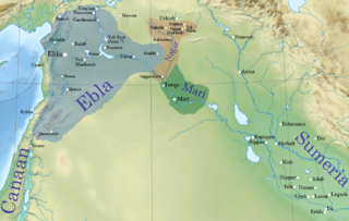
English: Ebla' first kingdom at its height c. 2340 BC.
The first Eblaite kingdom extended from Urshu in the north,1 to Damascus area in the south.2 And from Phoenicia and the coastal mountains in the west,3 4 to Tuttul,5 and Haddu in the east.6 The eastern kingdom of Nagar controlled most of the Khabur basin from the river junction with the Euphrates to the northwestern part at Nabada.7 Page 101 |
| 日期 | |
| 来源 | File:Near_East_topographic_map-blank.svg |
| 作者 | Sémhur |
| 这是一张修改过的图片,这意味着它已在原版本的基础上通过软件进行了编辑,改动内容:First Eblaite Empire。其原始版本为:Near East topographic map-blank.svg。修改者:Attar-Aram syria。
|
许可协议
[编辑]
本文件采用知识共享署名-相同方式共享 4.0 国际许可协议授权。
- 您可以自由地:
- 共享 – 复制、发行并传播本作品
- 修改 – 改编作品
- 惟须遵守下列条件:
- 署名 – 您必须对作品进行署名,提供授权条款的链接,并说明是否对原始内容进行了更改。您可以用任何合理的方式来署名,但不得以任何方式表明许可人认可您或您的使用。
- 相同方式共享 – 如果您再混合、转换或者基于本作品进行创作,您必须以与原先许可协议相同或相兼容的许可协议分发您贡献的作品。
原始上传日志
[编辑]
This image is a derivative work of the following images:
- File:Near_East_topographic_map-blank.svg licensed with Cc-by-sa-3.0,2.5,2.0,1.0, GFDL
- 2009-08-18T18:31:37Z Sémhur 2425x1581 (2442670 Bytes) 3 - New try
- 2009-08-17T15:39:22Z Sémhur 2425x1581 (1815374 Bytes) 2 - With the background...
- 2009-08-17T15:37:36Z Sémhur 2425x1581 (2836 Bytes) {{Information |Description={{en|1=Blank physical map of the [[:en:Near East|Near East]]}} {{fr|1=Carte physique vierge du [[:fr:Proche-Orient|Proche-Orient]].}} |Source={{own}} |Author=[[User:Sémhur|Sémhur]] |Date=2008-08-1
文件历史
点击某个日期/时间查看对应时刻的文件。
| 日期/时间 | 缩略图 | 大小 | 用户 | 备注 | |
|---|---|---|---|---|---|
| 当前 | 2015年6月13日 (六) 07:20 | | 1,324 × 841(1.29 MB) | Attar-Aram syria(留言 | 贡献) | borders |
| 2015年6月12日 (五) 21:38 |  | 1,324 × 841(1.3 MB) | Attar-Aram syria(留言 | 贡献) | color | |
| 2015年3月16日 (一) 02:29 |  | 1,324 × 844(1.29 MB) | Attar-Aram syria(留言 | 贡献) | tell hazna | |
| 2015年3月8日 (日) 18:00 |  | 1,324 × 844(1.1 MB) | Attar-Aram syria(留言 | 贡献) | added nagar | |
| 2015年2月26日 (四) 18:19 |  | 1,326 × 926(1.38 MB) | Attar-Aram syria(留言 | 贡献) | Haddu | |
| 2014年12月23日 (二) 05:36 |  | 1,326 × 926(1.38 MB) | Attar-Aram syria(留言 | 贡献) | fixed locations | |
| 2014年12月23日 (二) 02:38 |  | 1,326 × 926(1.38 MB) | Attar-Aram syria(留言 | 贡献) | borders | |
| 2014年12月23日 (二) 02:31 |  | 1,326 × 926(1.38 MB) | Attar-Aram syria(留言 | 贡献) | User created page with UploadWizard |
您不可以覆盖此文件。
文件用途
没有页面使用本文件。
全域文件用途
以下其他wiki使用此文件:
- am.wikipedia.org上的用途
- ba.wikipedia.org上的用途
- da.wikipedia.org上的用途
- en.wikipedia.org上的用途
- History of the ancient Levant
- Ebla
- Irkab-Damu
- Tell Brak
- Middle Eastern empires
- Early Dynastic Period (Mesopotamia)
- User:배우는사람/Test
- User:Kazkaskazkasako/Books/History
- Igrish-Halam
- User:SomeGuyWhoRandomlyEdits/History of Sumer
- User:SomeGuyWhoRandomlyEdits/Early Dynastic IIIa
- User:SomeGuyWhoRandomlyEdits/List of conflicts in the Near East
- User:Jacksonmcdonald3425/sandbox
- fa.wikipedia.org上的用途
- fi.wikipedia.org上的用途
- fi.wikibooks.org上的用途
- fr.wikipedia.org上的用途
- he.wikipedia.org上的用途
- id.wikipedia.org上的用途
- it.wikipedia.org上的用途
- lt.wikipedia.org上的用途
查看此文件的更多全域用途。