File:First Republic of Armenia in 1918-1920.png
跳至導覽
跳至搜尋

預覽大小:799 × 348 像素。 其他解析度:320 × 139 像素 | 640 × 279 像素 | 1,024 × 446 像素 | 1,280 × 558 像素 | 2,560 × 1,115 像素 | 8,192 × 3,568 像素。
原始檔案 (8,192 × 3,568 像素,檔案大小:14.85 MB,MIME 類型:image/png)
說明
說明
添加單行說明來描述出檔案所代表的內容
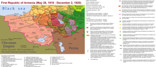
The First Republic of Armenia in 1918-1920.
摘要
[編輯]
| 描述 |
English: The First Republic of Armenia in 1918-1920. |
| 日期 | |
| 來源 | 自己的作品 |
| 作者 | Accipite7 |
授權條款
[編輯]
我,本作品的著作權持有者,決定用以下授權條款發佈本作品:
此檔案採用共享創意 姓名標示-相同方式分享 4.0 國際授權條款。
- 您可以自由:
- 分享 – 複製、發佈和傳播本作品
- 重新修改 – 創作演繹作品
- 惟需遵照下列條件:
- 姓名標示 – 您必須指名出正確的製作者,和提供授權條款的連結,以及表示是否有對內容上做出變更。您可以用任何合理的方式來行動,但不得以任何方式表明授權條款是對您許可或是由您所使用。
- 相同方式分享 – 如果您利用本素材進行再混合、轉換或創作,您必須基於如同原先的相同或兼容的條款,來分布您的貢獻成品。
檔案歷史
點選日期/時間以檢視該時間的檔案版本。
| 日期/時間 | 縮圖 | 尺寸 | 用戶 | 備註 | |
|---|---|---|---|---|---|
| 目前 | 2021年6月2日 (三) 15:13 | | 8,192 × 3,568(14.85 MB) | Accipite7(對話 | 貢獻) | for the convenience of viewing small details, the size is increased, the colors are improved |
| 2021年5月25日 (二) 08:17 |  | 4,096 × 1,784(3.69 MB) | Accipite7(對話 | 貢獻) | The border between Nahang of Shirak and Nahang of Syunik has been clarified. | |
| 2021年5月21日 (五) 09:59 |  | 4,096 × 1,784(3.7 MB) | Accipite7(對話 | 貢獻) | The temporary border between the Republic of Armenia and the Soviet republics (August 10, 1920) in the Nakhichevan county has been clarified. Added a legend marked on the map under the number 26. | |
| 2021年5月13日 (四) 08:35 |  | 4,096 × 1,784(3.97 MB) | Accipite7(對話 | 貢獻) | fixed typo | |
| 2021年5月13日 (四) 08:27 |  | 4,096 × 1,784(3.97 MB) | Accipite7(對話 | 貢獻) | The names of the types of administrative units of the former Russian Empire have been clarified: uyezd = county, okrug = district, oblast = territory, guberniya = governorate. | |
| 2021年5月12日 (三) 11:14 |  | 4,096 × 1,784(3.71 MB) | Accipite7(對話 | 貢獻) | Corrected data in the map legend regarding what is indicated on the map by numbers. Clarified the boundaries of the territories required at the Paris Peace Conference. I strongly ask the user of Culminatio not to vandalize and not return the map to the version on which he marked the line reached as a result of the Turkish offensive in 1920. Since, firstly, it is neural: Batumi, Artvin and Ardahan were under the control of the Democratic Republic of Georgia until February-March 1921. And secon... | |
| 2021年5月12日 (三) 04:13 |  | 5,375 × 2,341(7.18 MB) | Culminatio(對話 | 貢獻) | Reverted to version as of 15:05, 8 May 2021 (UTC) | |
| 2021年5月11日 (二) 07:11 |  | 4,096 × 1,784(3.99 MB) | Accipite7(對話 | 貢獻) | The boundaries of the territory of the demands of the Armenian delegation in the Transcaucasus, submitted to the Paris Peace Conference of 1919, were clarified. There is no need to overload the map with the line reached by the Turkish forces in 1920, as the map already shows the results of the Armenian-Turkish war of 1920 - the border according to the Treaty of Alexandropol, December 2, 1920 | |
| 2021年5月8日 (六) 15:05 |  | 5,375 × 2,341(7.18 MB) | Culminatio(對話 | 貢獻) | Additional line of the turkish advance on the northern positions during the war of 1920. Additional numbers 10,19,20,21 on the map. | |
| 2021年5月8日 (六) 10:49 |  | 6,336 × 2,760(2.21 MB) | Accipite7(對話 | 貢獻) | Improved colors. |
無法覆蓋此檔案。
檔案用途
下列頁面有用到此檔案:
全域檔案使用狀況
以下其他 wiki 使用了這個檔案:
- az.wikipedia.org 的使用狀況
- be.wikipedia.org 的使用狀況
- bg.wikipedia.org 的使用狀況
- de.wikipedia.org 的使用狀況
- el.wikipedia.org 的使用狀況
- fi.wikipedia.org 的使用狀況
- fr.wikipedia.org 的使用狀況
- hy.wikipedia.org 的使用狀況
- it.wikipedia.org 的使用狀況
- nl.wikipedia.org 的使用狀況
- pl.wikipedia.org 的使用狀況
- pt.wikipedia.org 的使用狀況
- ro.wikipedia.org 的使用狀況
- ru.wikipedia.org 的使用狀況
- sr.wikipedia.org 的使用狀況
- uk.wikipedia.org 的使用狀況
- zh.wikipedia.org 的使用狀況