File:Flag-map of the world (1914).png
跳转到导航
跳转到搜索
本预览的尺寸:800 × 397像素。 其他分辨率:320 × 159像素 | 640 × 318像素 | 1,024 × 508像素 | 1,280 × 635像素 | 2,560 × 1,271像素 | 4,500 × 2,234像素。
原始文件 (4,500 × 2,234像素,文件大小:540 KB,MIME类型:image/png)
说明
说明
添加一行文字以描述该文件所表现的内容
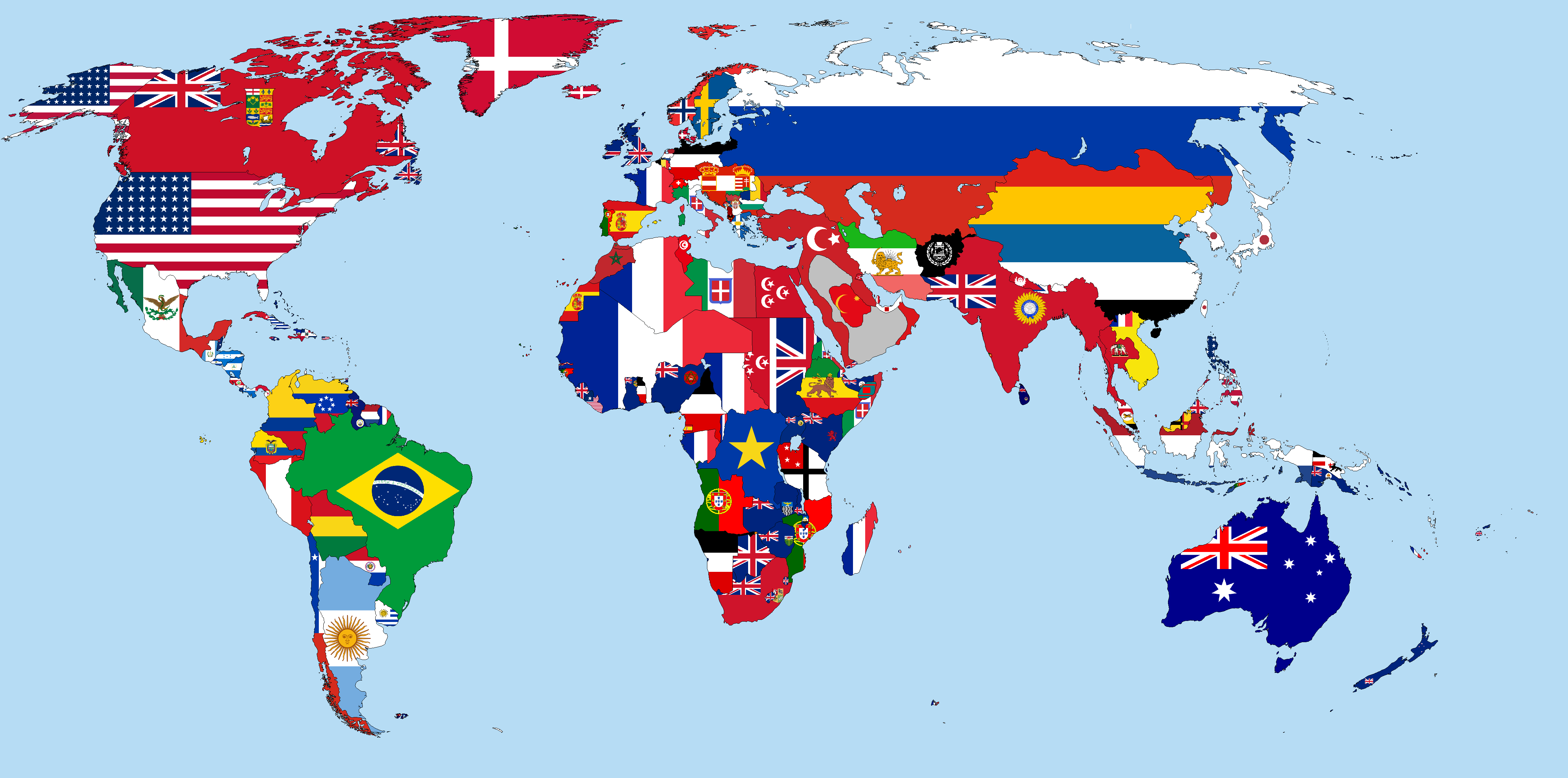
Map of the world in 1914 with visible borders and countries marked by their respective flags.

|
此flag map图片可使用矢量图形重新创建为SVG文件。这具有很多好处;更多信息请参见共享资源:待清理媒体。如果存在此图片的SVG格式,请将其上传,然后将此模板替换为
{{vector version available|新图片名称}}。
建议您将SVG命名为“Flag-map of the world (1914).svg”,这样在使用Vector version available(或Vva)模板时就不需要填写新图片名称参数。 |
摘要
| 描述 |
English: This is a world map in 1914, which shows flags of countries and colonies covering their territory. It is in Kavrayskiy VII projection.
|
|||||
| 日期 | ||||||
| 来源 | 自己的作品 | |||||
| 作者 | Alvin Lee | |||||
.png)
.png)
.png)
.png)
.png)
.png)
.png)
.png)
.png)
.png)
.png)
.png)
.png)
.png)
.png)
.png)
.png)
.png)
.png)
.png)
.png)
.png)
.png)
.png)
.png)
.png)
.png)
.png)
.png)
许可协议
我,本作品著作权人,特此采用以下许可协议发表本作品:
本文件采用知识共享署名-相同方式共享 3.0 未本地化版本许可协议授权。
- 您可以自由地:
- 共享 – 复制、发行并传播本作品
- 修改 – 改编作品
- 惟须遵守下列条件:
- 署名 – 您必须对作品进行署名,提供授权条款的链接,并说明是否对原始内容进行了更改。您可以用任何合理的方式来署名,但不得以任何方式表明许可人认可您或您的使用。
- 相同方式共享 – 如果您再混合、转换或者基于本作品进行创作,您必须以与原先许可协议相同或相兼容的许可协议分发您贡献的作品。
文件历史
点击某个日期/时间查看对应时刻的文件。
.png&uselang=zh&dir=prev)
.png&uselang=zh&offset=20150205193715)
.png&uselang=zh&offset=&limit=20)
.png&uselang=zh&offset=&limit=50)
.png&uselang=zh&offset=&limit=100)
.png&uselang=zh&offset=&limit=250)
.png&uselang=zh&offset=&limit=500)
| 日期/时间 | 缩略图 | 大小 | 用户 | 备注 | |
|---|---|---|---|---|---|
| 当前 | 2024年7月4日 (四) 00:51 | | 4,500 × 2,234(540 KB) | NatoTheVideoEditor AUTTP 2023 Est. 2011(留言 | 贡献) | Reverted to version as of 14:58, 22 June 2023 (UTC) |
| 2023年8月11日 (五) 00:28 |  | 4,500 × 2,234(529 KB) | Поль Крол Злой Диктатор(留言 | 贡献) | Reverted to version as of 19:08, 28 February 2023 (UTC) | |
| 2023年6月22日 (四) 14:58 |  | 4,500 × 2,234(540 KB) | NatoTheVideoEditor AUTTP 2023 Est. 2011(留言 | 贡献) | Reverted to version as of 18:07, 19 November 2022 (UTC) | |
| 2023年2月28日 (二) 19:08 |  | 4,500 × 2,234(529 KB) | Marcomogollon(留言 | 贡献) | Ecuador has never had access to the Amazon River since its independence, this is a hoax without evidence. The region passed into Peruvian hands from the colony by means of a Royal Decree of 1802 | |
| 2022年11月19日 (六) 18:07 |  | 4,500 × 2,234(540 KB) | NSassin(留言 | 贡献) | Changed the Alaskan flag to that of the United States, and added a border around the Dervish State. | |
| 2022年1月27日 (四) 21:18 |  | 4,500 × 2,234(537 KB) | Randomastwritter(留言 | 贡献) | added dervish | |
| 2015年7月30日 (四) 19:50 |  | 4,500 × 2,234(537 KB) | NSassin(留言 | 贡献) | Reverted Arabia back to the Emirate of Jabal Shammar. | |
| 2015年3月25日 (三) 16:18 |  | 4,500 × 2,234(542 KB) | Alvin Lee(留言 | 贡献) | Removing Antarctica | |
| 2015年2月11日 (三) 21:25 |  | 4,500 × 2,583(560 KB) | NSassin(留言 | 贡献) | Made the flags of Goa and Timor Leste a little more clear and made the border of Mozambique smoother. | |
| 2015年2月5日 (四) 19:37 |  | 4,500 × 2,583(518 KB) | Carcaça Metáliaca(留言 | 贡献) | Fixing Goa and Timor Leste flags, and also fixing borders on Mozambique |
您不可以覆盖此文件。
文件用途
以下2个页面使用本文件:
全域文件用途
以下其他wiki使用此文件:
- ba.wikipedia.org上的用途
- bg.wikipedia.org上的用途
- de.wikipedia.org上的用途
- en.wikipedia.org上的用途
- es.wikipedia.org上的用途
- hy.wikipedia.org上的用途
- hyw.wikipedia.org上的用途
- pt.wikipedia.org上的用途
- ro.wikipedia.org上的用途
- ru.wikipedia.org上的用途
- sk.wikipedia.org上的用途
- zh.wikipedia.org上的用途
.png&oldid=891865081)