File:Flag of Bosnia and Herzegovina (construction sheet).svg

Archivo original (archivo SVG, nominalmente 1290 × 690 píxeles, tamaño de archivo: 16 kB)
Leyendas
Leyendas
Resumen
[editar].svg&action=edit§ion=1)
| Descripción |
English: Flag of Bosnia and Herzegovina — construction sheet |
| Fecha | |
| Fuente |
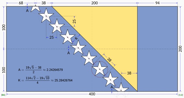
Trabajo propio. This construction sheet is derived from multiple sources:
The specification drawing provides:
The triangle is isosceles with one edge running at 45° relative to the edges of the flag. According to the law, the stars are supposed to parallel to the triangle's edge, so it stands that the line of stars must run in a precise 45° line. The law does not explicitly dictate the precise placement of the stars. Close examination of the government EPS drawing reveals most of the intended geometry:
The only missing information is the precise horizontal positioning of the line of stars. Based on measurements from the government EPS drawing, the vertical centerline of the centre star is located at distance from the hoist that is roughly 42.4% of the length of the flag. The centre star was chosen for the measurement because the line of stars in the EPS drawing runs at about 45.5° instead of the 45° dictated by the law. The same measurement repeated on the specification drawing reveals a distance of about 41.8% of the length of the flag with the line of stars again at 45.5°. For the purpose of this Wikimedia construction sheet, the distance from the hoist to the vertical centerline of the centre star is assumed to be exactly 42.0% of the length of the flag. All the other stars are laid out with equal spacing on a precise 45° degree line. Vertical coordinates of the stars are controlled by the intersections of the top and bottom stars with the flag edges. |
| Autor | MapGrid |
Licencia
[editar].svg&action=edit§ion=2)

|
Esta imagen representa una bandera, un escudo, un sello o alguna otra insignia oficial. El uso de estos símbolos está restringido en muchos países. Estas restricciones son independientes del estado de sus derechos de autor. |
| Yo, el titular de los derechos de autor de esta obra, lo libero al dominio público. Esto aplica en todo el mundo. En algunos países esto puede no ser legalmente factible; si ello ocurriese: Concedo a cualquier persona el derecho de usar este trabajo para cualquier propósito, sin ningún tipo de condición al menos que éstas sean requeridas por la ley. |
Historial del archivo
Haz clic sobre una fecha y hora para ver el archivo tal como apareció en ese momento.
| Fecha y hora | Miniatura | Dimensiones | Usuario | Comentario | |
|---|---|---|---|---|---|
| actual | 13:58 17 ene 2023 | | 1290 × 690 (16 kB) | MapGrid (discusión | contribs.) | Reverted to version as of 13:48, 17 January 2023 (UTC) |
| 13:51 17 ene 2023 |  | 1290 × 690 (16 kB) | MapGrid (discusión | contribs.) | ... slightly darker vertical centerline. | |
| 13:48 17 ene 2023 |  | 1290 × 690 (16 kB) | MapGrid (discusión | contribs.) | Added an opaque background. Added vertical centerline. No change to flag geometry. | |
| 16:00 23 ene 2022 |  | 1290 × 690 (16 kB) | MapGrid (discusión | contribs.) | Uploaded own work with UploadWizard |
No puedes sobrescribir este archivo.
Usos del archivo
Las siguientes páginas usan este archivo:
.svg)
.svg)
.svg)
Uso global del archivo
Las wikis siguientes utilizan este archivo:
- Uso en af.wikipedia.org
- Uso en cs.wikipedia.org
- Uso en en.wikipedia.org
- Uso en hr.wikipedia.org
- Uso en nl.wikipedia.org
- Uso en uk.wikipedia.org
- Uso en zh.wikipedia.org
.svg&oldid=822460732)