File:Flag of Chanan.svg
Aller à la navigation
Aller à la recherche

Taille de cet aperçu PNG pour ce fichier SVG : 800 × 533 pixels. Autres résolutions : 320 × 213 pixels | 640 × 427 pixels | 1 024 × 683 pixels | 1 280 × 853 pixels | 2 560 × 1 707 pixels.
Fichier d’origine (Fichier SVG, nominalement de 900 × 600 pixels, taille : 232 octet)
Légendes
Légendes
Ajoutez en une ligne la description de ce que représente ce fichier
Description
[modifier]
| Description |
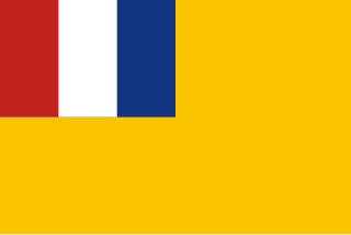
English: Flag of South Chahar Autonomous Government. (1937) Source: [1] 中文(简体):zh:察南自治政府旗。 |
| Date | |
| Source | Travail personnel, based on [2]. |
| Auteur | Ericmetro |
![[1]](http://pic5.997788.com/pic_search/00/23/46/73/se23467311.jpg)
Conditions d’utilisation
[modifier]
| Moi, propriétaire des droits d’auteur sur cette œuvre, la place dans le domaine public. Ceci s'applique dans le monde entier. Dans certains pays, ceci peut ne pas être possible ; dans ce cas : J’accorde à toute personne le droit d’utiliser cette œuvre dans n’importe quel but, sans aucune condition, sauf celles requises par la loi. |
Historique du fichier
Cliquer sur une date et heure pour voir le fichier tel qu'il était à ce moment-là.
| Date et heure | Vignette | Dimensions | Utilisateur | Commentaire | |
|---|---|---|---|---|---|
| actuel | 3 octobre 2023 à 00:20 | | 900 × 600 (232 octet) | Colohisto (d | contributions) | Simpler code |
| 13 avril 2016 à 08:10 |  | 900 × 600 (310 octet) | Alkari (d | contributions) | code cleanup | |
| 21 août 2014 à 16:23 |  | 900 × 600 (3 kio) | Ericmetro (d | contributions) | User created page with UploadWizard |
Vous ne pouvez pas remplacer ce fichier.
Utilisations locales du fichier
Les 3 pages suivantes utilisent ce fichier :
Utilisations du fichier sur d’autres wikis
Les autres wikis suivants utilisent ce fichier :
- Utilisation sur ar.wikipedia.org
- Utilisation sur be.wikipedia.org
- Utilisation sur bs.wikipedia.org
- Utilisation sur en.wikipedia.org
- French Indochina
- Manchukuo
- Puppet state
- Asiatic-Pacific theater
- Empire of Japan
- Mengjiang
- Greater East Asia Co-Prosperity Sphere
- Pacific War
- Sook Ching
- Azad Hind
- South Seas Mandate
- Wang Jingwei regime
- Great Way Government
- Japanese occupation of Hong Kong
- Japanese occupation of Singapore
- Five Races Under One Union
- List of Chinese flags
- French protectorate of Laos
- Reformed Government of the Republic of China
- Japanese occupation of Malaya
- Empire of Vietnam
- Taiwan under Japanese rule
- Provisional Government of the Republic of China (1937–1940)
- Manchukuo Imperial Army
- Japanese occupation of the Dutch East Indies
- East Hebei Autonomous Government
- Collaborationist Chinese Army
- Second Philippine Republic
- Hebei–Chahar Political Council
- State of Burma
- Template:Country data Mengjiang
- Japanese coup d'état in French Indochina
- Japanese occupation of Guam
- Thailand in World War II
- Greater East Asia Conference
- Template:States and territories in the sphere of influence of the Empire of Japan during World War II
- Flag of Mengjiang
- Japanese occupation of Cambodia
- Japanese occupation of Nauru
- User:InforManiac/Navbox20
- Japanese occupation of British Borneo
- List of World War II puppet states
- North Shanxi Autonomous Government
- Kingdom of Kampuchea (1945)
- Japanese occupation of the Gilbert Islands
- Japanese occupation of the Solomon Islands
Voir davantage sur l’utilisation globale de ce fichier.