File:Flag of Oppland.svg
Przejdź do nawigacji
Przejdź do wyszukiwania

Wielkość pliku podglądu PNG dla pliku SVG: 800 × 600 pikseli Inne rozdzielczości: 320 × 240 pikseli | 640 × 480 pikseli | 1024 × 768 pikseli | 1280 × 960 pikseli | 2560 × 1920 pikseli | 1200 × 900 pikseli.
Rozmiar pierwotny (Plik SVG, nominalnie 1200 × 900 pikseli, rozmiar pliku: 6 KB)
Podpisy
Podpisy
Dodaj jednolinijkowe objaśnienie tego, co ten plik pokazuje
| Opis |
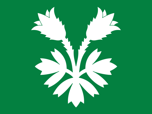
English: The flag of the former county of Oppland, Norway. Its design is shared with the county arms, and shows a spring pasqueflower. This distinctive plant is prevalent in the mountainous parts of Oppland, a county with 80% of its area situated above 600 m.a.s.l. The lush, lower‐lying parts of the county are included by the green background. Oppland's traditional districts are represented by the different parts of the plant: the two flowers stand for the Valdres and Gudbrand valleys, while the three leaves stand for the lowland districts of Land, Hadeland, and Toten. The flag was decided upon by the county council 1989‐03‐13, and approved by royal resolution 1989‐06‐23. |
||
| Data | |||
| Źródło |
Oppland fylke, flagg – Arkivverkets digitale fotoarkiv Godkjenning av våpen og flagg, Oppland fylkeskommune – Lovdata |
||
| Autor |
Arvid Sveen, vectorization by VulpesVulpes42 |
||
| Licencja (Ponowne użycie tego pliku) |
|

|
Ta grafika przedstawia flagę, herb, pieczęć lub inne insygnia. Użycie takich symboli jest ograniczone w wielu krajach. Te ograniczenia są niezależne od praw autorskich. |
Historia pliku
Kliknij na odpowiedniej dacie/czasie, aby zobaczyć wersję pliku z tamtego okresu.
| Data/czas | Miniatura | Wymiary | Użytkownik | Opis | |
|---|---|---|---|---|---|
| aktualny | 17:28, 23 gru 2022 | | 1200 × 900 (6 KB) | Espandero (dyskusja | edycje) | Reverted to version as of 11:35, 9 August 2022 (UTC) no reason given for revert |
| 17:27, 21 gru 2022 |  | 1000 × 750 (10 KB) | YoanTaskov (dyskusja | edycje) | Reverted to version as of 09:45, 20 March 2006 (UTC) | |
| 11:35, 9 sie 2022 |  | 1200 × 900 (6 KB) | VulpesVulpes42 (dyskusja | edycje) | Updated the colors. | |
| 20:15, 30 sie 2021 |  | 1200 × 900 (6 KB) | VulpesVulpes42 (dyskusja | edycje) | Redrew the flag myself to more closely match the original drawing. | |
| 07:32, 22 mar 2006 |  | 1000 × 750 (10 KB) | Denelson83 (dyskusja | edycje) | Improved version, from same source, PD | |
| 09:45, 20 mar 2006 |  | 1000 × 750 (10 KB) | Denelson83 (dyskusja | edycje) | Flag of w:Oppland in w:Norway. Courtesy of an e-mail from the author of xrmap. {{PD-because|the author of xrmap created this image. He has previously stated that his images are in the public domain.}} Category:Flags of Norway [[Category:SV |
Nie możesz nadpisać tego pliku.
Lokalne wykorzystanie pliku
Następujące strony korzystają z tego pliku:
- Flags of counties of Norway
- Gallery of flags with plants
- Wikimedia logo mosaic/Colours gallery/Green
- User:VulpesVulpes42
- User:VulpesVulpes42/Gallery/Norske flagg
- File:Flag of Oppland (Norway).svg (przekierowanie do pliku)
- Category:Births in Oppland
- Category:Maps of Oppland
- Category:Oppland
- Category:People of Oppland
.svg&redirect=no)
Globalne wykorzystanie pliku
Ten plik jest wykorzystywany także w innych projektach wiki:
- Wykorzystanie na ar.wikipedia.org
- Wykorzystanie na azb.wikipedia.org
- Wykorzystanie na be.wikipedia.org
- Wykorzystanie na bg.wikipedia.org
- Wykorzystanie na bs.wikipedia.org
- Wykorzystanie na ca.wikipedia.org
- Wykorzystanie na ceb.wikipedia.org
- Wykorzystanie na cs.wikipedia.org
- Wykorzystanie na de.wikipedia.org
- Wykorzystanie na en.wikipedia.org
- Oppland
- User talk:Sherurcij
- User talk:Bedford
- User talk:Coasttocoast
- List of Norwegian flags
- User talk:Pufferfish101
- Flags of Norwegian subdivisions
- User talk:Damërung
- User talk:Guettarda/Archive18
- User talk:C4v3m4n
- Wikipedia:WikiProject Aviation/Contest
- User talk:03md/archive 4
- List of political and geographic subdivisions by total area from 20,000 to 50,000 square kilometers
- User talk:AtheWeatherman
- User talk:Magioladitis/Archive 1
- User talk:Mrathel
- User talk:Resolute/Archive 4
- List of political and geographic subdivisions by total area (all)
- User talk:MasterOfHisOwnDomain/Archive 1
- List of political and geographic subdivisions by total area from 20,000 to 30,000 square kilometers
- User talk:Marshall Williams2
- User talk:Tosão
- User talk:MuZemike/Archive 4
- User talk:Arsenikk/Archive 2
- User talk:Yotcmdr
- User talk:Charles Edward/archive3
- Wikipedia talk:WikiProject Aviation/Archive 3
- User talk:Unitanode
- User:Mikhailov Kusserow/Green
- User:Michel Mapaliey/Green
- User talk:Abductive/Archive 1
- User talk:Billbowery
- User talk:Mifter/Archive 5
- User talk:Nergaal/Archive 5
- Wikipedia:WikiProject Aviation/Contest/Signups
- Wikipedia:WikiProject Aviation/Contest/Poster
- Wikipedia:WikiProject Aviation/Contest/Poster/Flags
- Wikipedia talk:WikiProject Aviation/Contest
- User talk:Bejinhan/Archive 2
- User talk:Suomi Finland 2009
Pokaż listę globalnego wykorzystania tego pliku.