File:Flusssystemkarte Rhein 03.jpg
跳转到导航
跳转到搜索
本预览的尺寸:441 × 599像素。 其他分辨率:177 × 240像素 | 353 × 480像素 | 566 × 768像素 | 754 × 1,024像素 | 1,508 × 2,048像素 | 3,198 × 4,342像素。
原始文件 (3,198 × 4,342像素,文件大小:11.75 MB,MIME类型:image/jpeg)
说明
说明
添加一行文字以描述该文件所表现的内容
摘要[编辑]
| 描述 |
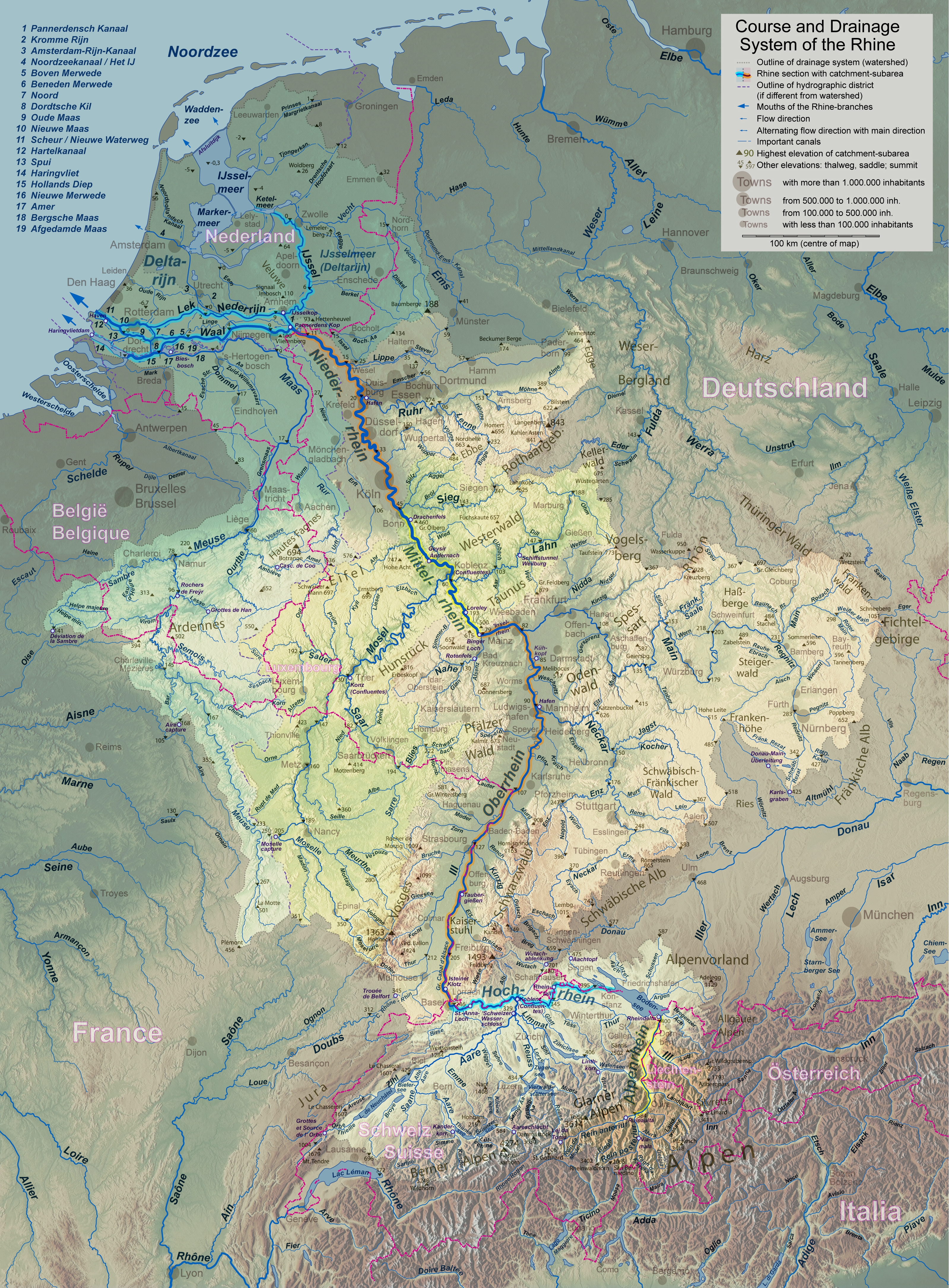
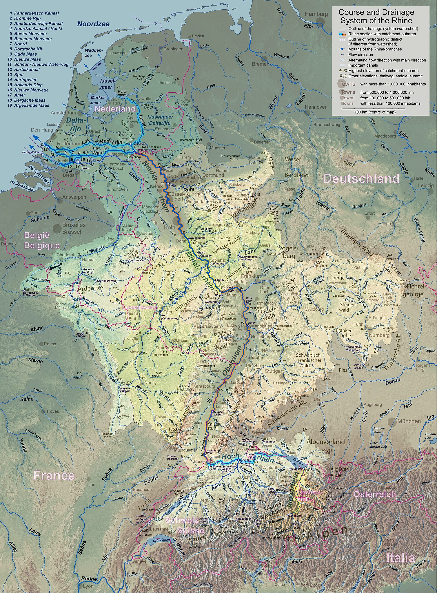
English: Rhine course and river system, place names in the countries' languages Deutsch: Rheinlauf und Flusssystem, beschriftet in jeweiligen Landessprachen Français : Cours du Rhin et son bassin versant, noms de lieux en langues nationales Nederlands: Verloop en rivierensysteem van de Rijn, plaatsnamen in landstalen |
| 日期 | |
| 来源 | 自己的作品 |
| 作者 | WWasser |
| 其他版本 | Versions in german, english, french, or dutch; for other languages the unlabelled version may be used. There are also less detailed maps of the river system with either german, english, french, dutch, or local names. A small version without names is available, too. |
| 相机位置 | | 在以下服务上查看本图像和附近其他图像: OpenStreetMap |
|---|
- Background relief created with Google Maps-For-Free SRTM3 Webserver
- Topography derived from Open Street Map
- Outlines of catchment areas derived from relief data (in the Netherlands also taken from several ICPR (International Commission for the Protection of the Rhine)- and Rijkswaterstaat-publications)
许可协议[编辑]
我,本作品著作权人,特此采用以下许可协议发表本作品:
本文件采用知识共享署名-相同方式共享 3.0 未本地化版本许可协议授权。
- 您可以自由地:
- 共享 – 复制、发行并传播本作品
- 修改 – 改编作品
- 惟须遵守下列条件:
- 署名 – 您必须对作品进行署名,提供授权条款的链接,并说明是否对原始内容进行了更改。您可以用任何合理的方式来署名,但不得以任何方式表明许可人认可您或您的使用。
- 相同方式共享 – 如果您再混合、转换或者基于本作品进行创作,您必须以与原先许可协议相同或相兼容的许可协议分发您贡献的作品。
文件历史
点击某个日期/时间查看对应时刻的文件。
| 日期/时间 | 缩略图 | 大小 | 用户 | 备注 | |
|---|---|---|---|---|---|
| 当前 | 2017年9月17日 (日) 18:24 | | 3,198 × 4,342(11.75 MB) | WWasser(留言 | 贡献) | Albertkanaal, Aa (Dommel), frontier lines in Lake of Constance |
| 2013年4月18日 (四) 12:15 |  | 2,399 × 3,256(4.72 MB) | WWasser(留言 | 贡献) | more details | |
| 2013年4月4日 (四) 16:23 |  | 2,131 × 2,895(4.24 MB) | WWasser(留言 | 贡献) | legend and colours | |
| 2013年3月5日 (二) 13:45 |  | 2,131 × 2,893(3.33 MB) | WWasser(留言 | 贡献) | some smaller rivers, elevations | |
| 2013年2月8日 (五) 13:17 |  | 2,132 × 2,895(3.06 MB) | WWasser(留言 | 贡献) | {{Information |Description ={{en|1=colours improved}} |Source =own |Author =WWasser |Date = |Permission = |other_versions = }} | |
| 2013年2月8日 (五) 08:12 |  | 2,132 × 2,895(3.1 MB) | WWasser(留言 | 贡献) | {{Information |Description ={{en|1=Rhine course and river system, place names in the countries' languages}} {{de|1=Rheinlauf und Flusssystem, beschriftet in jeweiligen Landessprachen}} {{fr|1=Cours du Rhin et son bassin versant, noms de lieux en lan... | |
| 2013年2月5日 (二) 16:04 |  | 4,262 × 5,790(4.23 MB) | WWasser(留言 | 贡献) | User created page with UploadWizard |
您不可以覆盖此文件。
文件用途
以下页面使用本文件:
全域文件用途
以下其他wiki使用此文件:
- am.wikipedia.org上的用途
- ast.wikipedia.org上的用途
- azb.wikipedia.org上的用途
- az.wiktionary.org上的用途
- bat-smg.wikipedia.org上的用途
- bo.wikipedia.org上的用途
- bs.wikipedia.org上的用途
- cs.wikipedia.org上的用途
- cv.wikipedia.org上的用途
- es.wikipedia.org上的用途
- fi.wikipedia.org上的用途
- hr.wikipedia.org上的用途
- hu.wikipedia.org上的用途
- id.wikipedia.org上的用途
- ie.wikipedia.org上的用途
- it.wikipedia.org上的用途
- jv.wikipedia.org上的用途
- kbp.wikipedia.org上的用途
- lt.wikipedia.org上的用途
- ms.wikipedia.org上的用途
- mwl.wikipedia.org上的用途
- nn.wikipedia.org上的用途
- no.wikipedia.org上的用途
- os.wikipedia.org上的用途
- pa.wikipedia.org上的用途
- pl.wikipedia.org上的用途
- pt.wikipedia.org上的用途
- ro.wikipedia.org上的用途
- sk.wikipedia.org上的用途
- sl.wikipedia.org上的用途
- sr.wikipedia.org上的用途
- sv.wikipedia.org上的用途
- uk.wikipedia.org上的用途
- zh.wikipedia.org上的用途