File:Flusssystemkarte Rhein 03.jpg
跳至導覽
跳至搜尋
預覽大小:441 × 599 像素。 其他解析度:177 × 240 像素 | 353 × 480 像素 | 566 × 768 像素 | 754 × 1,024 像素 | 1,508 × 2,048 像素 | 3,198 × 4,342 像素。
原始檔案 (3,198 × 4,342 像素,檔案大小:11.75 MB,MIME 類型:image/jpeg)
說明
說明
添加單行說明來描述出檔案所代表的內容
摘要[編輯]
| 描述 |
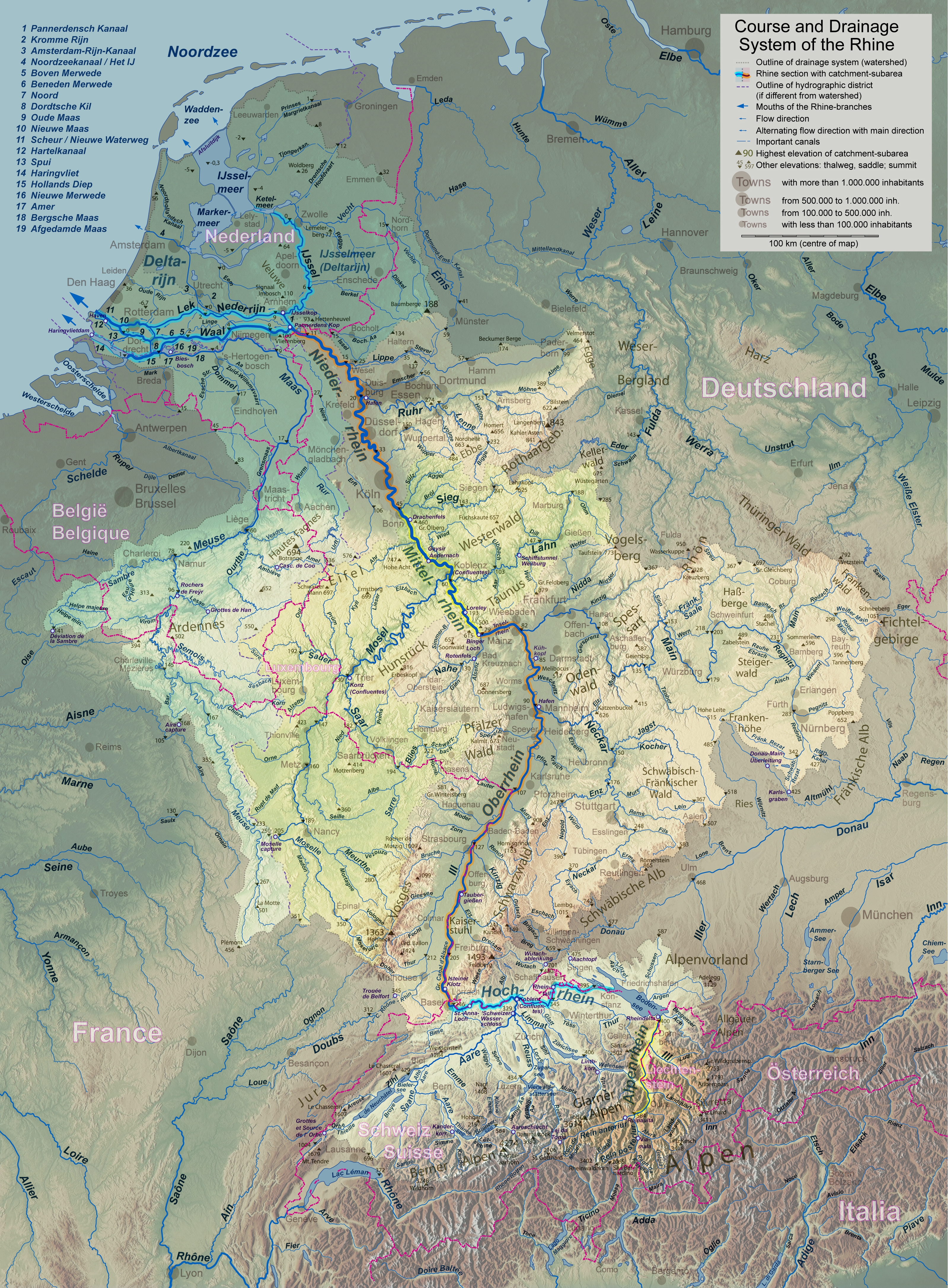
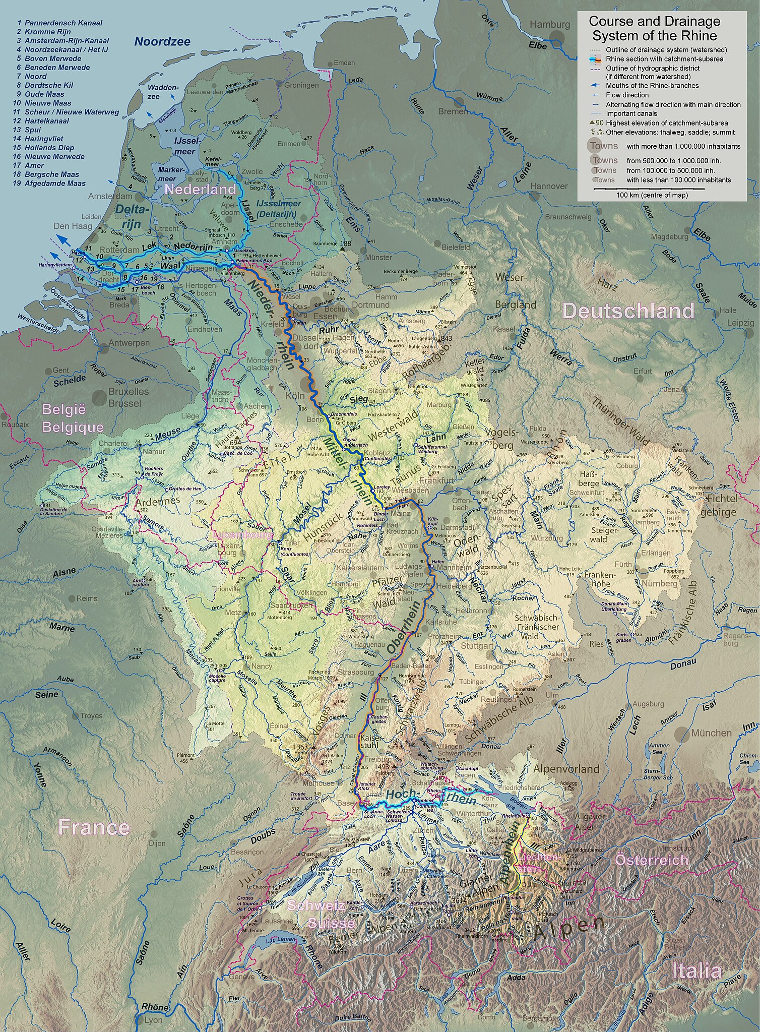
English: Rhine course and river system, place names in the countries' languages Deutsch: Rheinlauf und Flusssystem, beschriftet in jeweiligen Landessprachen Français : Cours du Rhin et son bassin versant, noms de lieux en langues nationales Nederlands: Verloop en rivierensysteem van de Rijn, plaatsnamen in landstalen |
| 日期 | |
| 來源 | 自己的作品 |
| 作者 | WWasser |
| 其他版本 | Versions in german, english, french, or dutch; for other languages the unlabelled version may be used. There are also less detailed maps of the river system with either german, english, french, dutch, or local names. A small version without names is available, too. |
| 拍攝地點 | | 位於此地的本圖片與其他圖片: OpenStreetMap |
|---|
- Background relief created with Google Maps-For-Free SRTM3 Webserver
- Topography derived from Open Street Map
- Outlines of catchment areas derived from relief data (in the Netherlands also taken from several ICPR (International Commission for the Protection of the Rhine)- and Rijkswaterstaat-publications)
授權條款[編輯]
我,本作品的著作權持有者,決定用以下授權條款發佈本作品:
此檔案採用共享創意 姓名標示-相同方式分享 3.0 未在地化版本授權條款。
- 您可以自由:
- 分享 – 複製、發佈和傳播本作品
- 重新修改 – 創作演繹作品
- 惟需遵照下列條件:
- 姓名標示 – 您必須指名出正確的製作者,和提供授權條款的連結,以及表示是否有對內容上做出變更。您可以用任何合理的方式來行動,但不得以任何方式表明授權條款是對您許可或是由您所使用。
- 相同方式分享 – 如果您利用本素材進行再混合、轉換或創作,您必須基於如同原先的相同或兼容的條款,來分布您的貢獻成品。
檔案歷史
點選日期/時間以檢視該時間的檔案版本。
| 日期/時間 | 縮圖 | 尺寸 | 用戶 | 備註 | |
|---|---|---|---|---|---|
| 目前 | 2017年9月17日 (日) 18:24 | | 3,198 × 4,342(11.75 MB) | WWasser(對話 | 貢獻) | Albertkanaal, Aa (Dommel), frontier lines in Lake of Constance |
| 2013年4月18日 (四) 12:15 |  | 2,399 × 3,256(4.72 MB) | WWasser(對話 | 貢獻) | more details | |
| 2013年4月4日 (四) 16:23 |  | 2,131 × 2,895(4.24 MB) | WWasser(對話 | 貢獻) | legend and colours | |
| 2013年3月5日 (二) 13:45 |  | 2,131 × 2,893(3.33 MB) | WWasser(對話 | 貢獻) | some smaller rivers, elevations | |
| 2013年2月8日 (五) 13:17 |  | 2,132 × 2,895(3.06 MB) | WWasser(對話 | 貢獻) | {{Information |Description ={{en|1=colours improved}} |Source =own |Author =WWasser |Date = |Permission = |other_versions = }} | |
| 2013年2月8日 (五) 08:12 |  | 2,132 × 2,895(3.1 MB) | WWasser(對話 | 貢獻) | {{Information |Description ={{en|1=Rhine course and river system, place names in the countries' languages}} {{de|1=Rheinlauf und Flusssystem, beschriftet in jeweiligen Landessprachen}} {{fr|1=Cours du Rhin et son bassin versant, noms de lieux en lan... | |
| 2013年2月5日 (二) 16:04 |  | 4,262 × 5,790(4.23 MB) | WWasser(對話 | 貢獻) | User created page with UploadWizard |
無法覆蓋此檔案。
檔案用途
下列頁面有用到此檔案:
全域檔案使用狀況
以下其他 wiki 使用了這個檔案:
- am.wikipedia.org 的使用狀況
- ast.wikipedia.org 的使用狀況
- azb.wikipedia.org 的使用狀況
- az.wiktionary.org 的使用狀況
- bat-smg.wikipedia.org 的使用狀況
- bo.wikipedia.org 的使用狀況
- bs.wikipedia.org 的使用狀況
- cs.wikipedia.org 的使用狀況
- cv.wikipedia.org 的使用狀況
- es.wikipedia.org 的使用狀況
- fi.wikipedia.org 的使用狀況
- hr.wikipedia.org 的使用狀況
- hu.wikipedia.org 的使用狀況
- id.wikipedia.org 的使用狀況
- ie.wikipedia.org 的使用狀況
- it.wikipedia.org 的使用狀況
- jv.wikipedia.org 的使用狀況
- kbp.wikipedia.org 的使用狀況
- lt.wikipedia.org 的使用狀況
- ms.wikipedia.org 的使用狀況
- mwl.wikipedia.org 的使用狀況
- nn.wikipedia.org 的使用狀況
- no.wikipedia.org 的使用狀況
- os.wikipedia.org 的使用狀況
- pa.wikipedia.org 的使用狀況
- pl.wikipedia.org 的使用狀況
- pt.wikipedia.org 的使用狀況
- ro.wikipedia.org 的使用狀況
- sk.wikipedia.org 的使用狀況
- sl.wikipedia.org 的使用狀況
- sr.wikipedia.org 的使用狀況
- sv.wikipedia.org 的使用狀況
- uk.wikipedia.org 的使用狀況
- zh.wikipedia.org 的使用狀況