File:Formula 1 all over the world-2020.svg
Siirry navigaatioon
Siirry hakuun

Tämän PNG-esikatselun koko koskien SVG-tiedostoa: 800 × 406 kuvapistettä. Muut resoluutiot: 320 × 162 kuvapistettä | 640 × 325 kuvapistettä | 1 024 × 520 kuvapistettä | 1 280 × 650 kuvapistettä | 2 560 × 1 300 kuvapistettä | 2 754 × 1 398 kuvapistettä.
Alkuperäinen tiedosto (SVG-tiedosto; oletustarkkuus 2 754 × 1 398 kuvapistettä; tiedostokoko 1,07 MiB)
Kuvatekstit
Kuvatekstit
Lisää yhden rivin pituinen kuvaus tästä tiedostosta
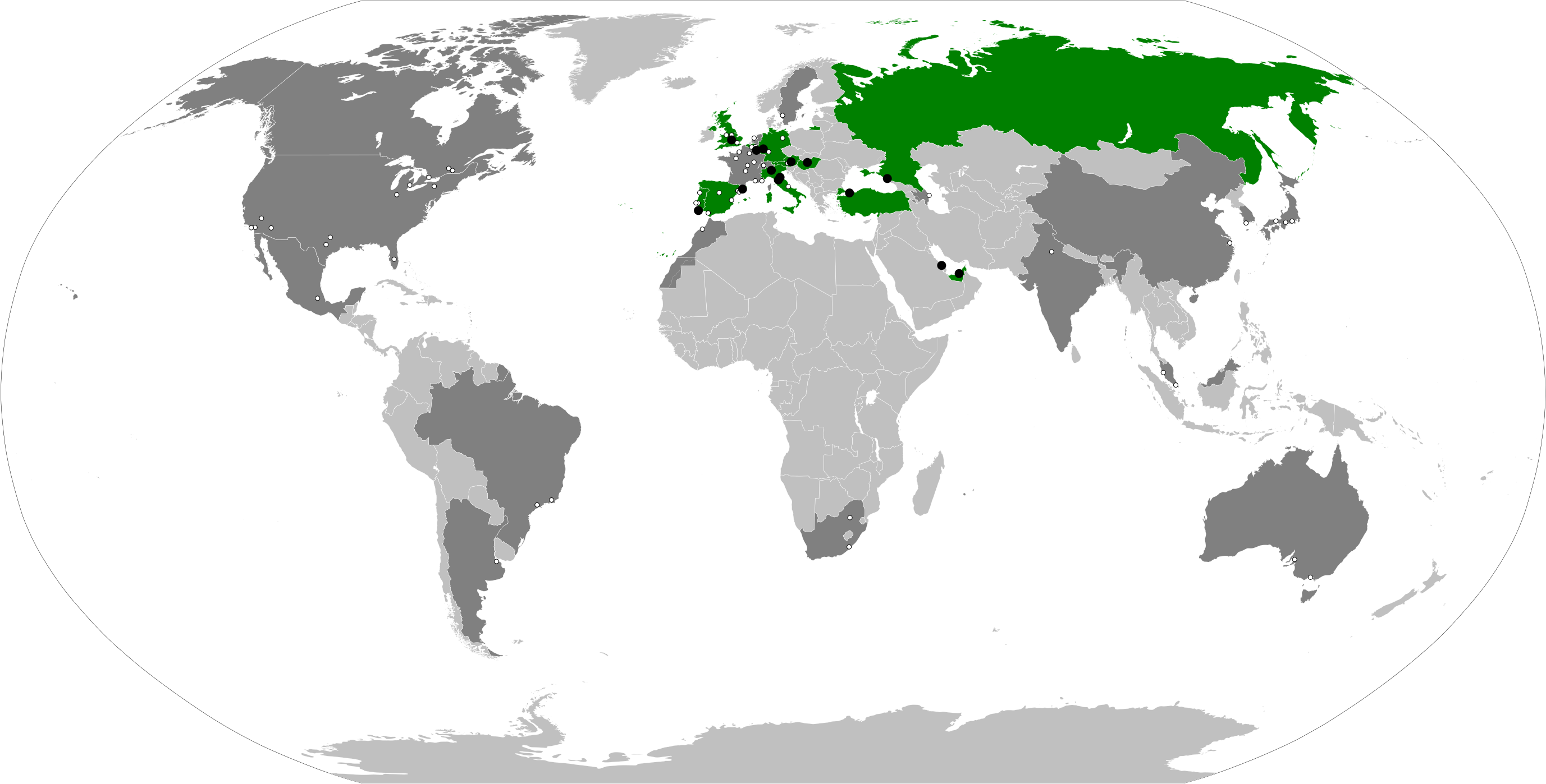
Countries marked in green are those that have hosted or will host a Grand Prix in 2020


|
The boundaries on this map show the de facto situation. This is just one of several different views on the subject (see COM:NPOV). |
Yhteenveto[muokkaa]
| Kuvaus |
English: Derivative of File:BlankMap-World.svg. Countries marked in green are those that hosted a Grand Prix in 2020. Those in dark gray had hosted a Formula One Grand Prix in the previous seasons, according to the List of Formula One circuits. Black dots show locations where races took place in 2020, while white dots show locations where races were held in the previous years. Note that for some areas where there were several tracks in close proximity such as Spain, Portugal, Italy and Austria, the dots may partially overlap. Countries shaded in light gray indicate countries that had never hosted a Formula One Grand Prix before 2020. |
| Päiväys | |
| Lähde | Oma teos, based on the information in List of Formula One circuits and 2020 Formula One season |
| Tekijä | Cherkash |
| Muut versiot |
Annual maps since 2012:
Obsolete versions (either no longer updated, incorrect, or not in a vector format): |
| SVG kehittely | Tämä vektorikuva luotiin käyttäen apuna ohjelmaa tekstimuokkaimella. |


Lisenssi[muokkaa]
Minä, tämän teoksen tekijänoikeuksien haltija, julkaisen täten tämän teoksen seuraavalla lisenssillä:
Tämä tiedosto on lisensoitu Creative Commons Nimeä-JaaSamoin 4.0 Kansainvälinen -lisenssillä.
- Voit:
- jakaa – kopioida, levittää ja esittää teosta
- remiksata – valmistaa muutettuja teoksia
- Seuraavilla ehdoilla:
- nimeäminen – Sinun on mainittava lähde asianmukaisesti, tarjottava linkki lisenssiin sekä merkittävä, mikäli olet tehnyt muutoksia. Voit tehdä yllä olevan millä tahansa kohtuullisella tavalla, mutta et siten, että annat ymmärtää lisenssinantajan suosittelevan sinua tai teoksen käyttöäsi.
- jaa samoin – Jos muutat tai perustat tähän työhön, voit jakaa tuloksena syntyvää työtä vain tällä tai tämän kaltaisella lisenssillä.
Tiedoston historia
Päiväystä napsauttamalla näet, millainen tiedosto oli kyseisellä hetkellä.
| Päiväys | Pienoiskuva | Koko | Käyttäjä | Kommentti | |
|---|---|---|---|---|---|
| nykyinen | 4. lokakuuta 2021 kello 18.07 | | 2 754 × 1 398 (1,07 MiB) | Cherkash (keskustelu | muokkaukset) | corrections to Yas Marina and Sakhir locations |
| 14. syyskuuta 2020 kello 16.31 |  | 2 754 × 1 398 (1,07 MiB) | Cherkash (keskustelu | muokkaukset) | updated per the final form of the calendar (17 races) | |
| 24. joulukuuta 2019 kello 14.42 |  | 2 754 × 1 398 (1,07 MiB) | Cherkash (keskustelu | muokkaukset) | Reverted to version as of 20:37, 26 September 2019 (UTC) rv to the de facto status of the territories | |
| 24. joulukuuta 2019 kello 08.26 |  | 2 754 × 1 398 (1,12 MiB) | Unas964 (keskustelu | muokkaukset) | Borders are shown according to FIA list that distinguishes China, Taiwan, Hong Kong as separate members, recognises Crimea as Ukrainian land and does not acknowledge occupied territories and/or puppet regimes ("borders" of Northern Cyprus, DNL/LNR, Transnistria, Nagorno-Karabakh, Tskhinvali Region, Abkhasia are removed). | |
| 26. syyskuuta 2019 kello 20.37 |  | 2 754 × 1 398 (1,07 MiB) | Cherkash (keskustelu | muokkaukset) | {{Information |description ={{en|1=Derivative of File:BlankMap-World.svg. Countries marked in green are those that have hosted (or are scheduled to host) a Grand Prix in 2020. Those in dark gray had hosted a Formula One Grand Prix in the previous seasons, according to the List of Formula One circuits. Black dots show locations where races are scheduled to take place in 2020, while white dots show locations where races were held in the previous years... |
Et voi tallentaa uutta tiedostoa tämän tilalle.
Tiedoston käyttö
Seuraavat 10 sivua käyttävät tätä tiedostoa:
- User:Adeletron 3030/botgalleries/Sports/2019 December 23-25
- User:Adeletron 3030/botgalleries/Sports/2019 September 25-27
- User:Adeletron 3030/botgalleries/Sports/2020 September 13-15
- User:Adeletron 3030/botgalleries/Sports/2021 October 3-4
- File:Formula 1 all over the world-2019 - UN borders.svg
- File:Formula 1 all over the world-2021.svg
- File:Formula 1 all over the world-2022.svg
- File:Formula 1 all over the world-2023.svg
- File:Formula 1 all over the world-2024.svg
- File:Formula 1 all over the world-2025.svg
Tiedoston järjestelmänlaajuinen käyttö
Seuraavat muut wikit käyttävät tätä tiedostoa:
- Käyttö kohteessa ar.wikipedia.org
- Käyttö kohteessa ca.wikipedia.org
- Käyttö kohteessa el.wikipedia.org
- Käyttö kohteessa en.wikipedia.org
- Käyttö kohteessa es.wikipedia.org
- Käyttö kohteessa et.wikipedia.org
- Käyttö kohteessa fa.wikipedia.org
- Käyttö kohteessa fi.wikipedia.org
- Käyttö kohteessa fr.wikipedia.org
- Käyttö kohteessa gl.wikipedia.org
- Käyttö kohteessa it.wikipedia.org
- Käyttö kohteessa lt.wikipedia.org
- Käyttö kohteessa lv.wikipedia.org
- Käyttö kohteessa nl.wikipedia.org
- Käyttö kohteessa no.wikipedia.org
- Käyttö kohteessa ro.wikipedia.org
- Käyttö kohteessa ru.wikipedia.org
- Käyttö kohteessa sk.wikipedia.org
- Käyttö kohteessa sr.wikipedia.org
- Käyttö kohteessa sv.wikipedia.org
- Käyttö kohteessa tr.wikipedia.org
- Käyttö kohteessa vi.wikipedia.org
- Käyttö kohteessa zh.wikipedia.org