File:Fort Douaumont location map 300px.jpg
Salta a la navegació
Salta a la cerca
No hi ha cap versió amb una resolució més gran.
Fort_Douaumont_location_map_300px.jpg (300 × 250 píxels, mida del fitxer: 53 Ko, tipus MIME: image/jpeg)
Llegendes
Llegendes
Afegeix una explicació d'una línia del que representa aquest fitxer
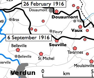
| Descripció | Basic 300-pixel thumbnail map showing location of Fort Doumont in relation to Verdun and the other forts north and northeast of Verdun. The lines of advance of German forces as at 26 February and 6 September 1916 are shown in black. The River Meuse is shown in blue at left. | ||||||||
| Data | Original version uploaded 16 December 2005. This clip created 11 January 2010. | ||||||||
| Font | Clipped and slightly modified from File:Battle of Verdun map.png by en:User:Gdr. | ||||||||
| Autor | en:User:Gdr. | ||||||||
| Permís (Com reutilitzar aquest fitxer) |
|
||||||||
| Altres versions |
Derivative works of this file: Défense de Verdun - forts de Vaux et de Douaumont.png |


Historial del fitxer
Cliqueu una data/hora per veure el fitxer tal com era aleshores.
| Data/hora | Miniatura | Dimensions | Usuari/a | Comentari | |
|---|---|---|---|---|---|
| actual | 16:27, 10 gen 2010 | | 300 × 250 (53 Ko) | Rcbutcher (discussió | contribucions) | {{Information |Description=Basic 300-pixel thumbnail map showing location of Fort Doumont in relation to Verdun and the other forts north and northeast of Verdun. The lines of advance of German forces as at 26 February and 6 Septemb |
No podeu sobreescriure aquest fitxer.
Ús del fitxer
La pàgina següent utilitza aquest fitxer:
Ús global del fitxer
Utilització d'aquest fitxer en altres wikis:
- Utilització a ca.wikipedia.org
- Utilització a en.wikipedia.org
- Utilització a tr.wikipedia.org
- Utilització a zh.wikipedia.org