File:Frankish Foederatus.png
Aller à la navigation
Aller à la recherche
Pas de plus haute résolution disponible.
Frankish_Foederatus.png (570 × 471 pixels, taille du fichier : 73 kio, type MIME : image/png)
Légendes
Légendes
Ajoutez en une ligne la description de ce que représente ce fichier
Description
[modifier]
| Description |
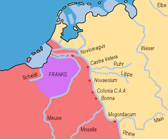
English: The Frankish Foederati' around 360 A.D; based on the maps present at the tacitus.nu website; LINK; showing the Frankish expansion. |
| Date | |
| Source | Travail personnel |
| Auteur | HP1740-B |
Conditions d’utilisation
[modifier]
| Moi, propriétaire des droits d’auteur sur cette œuvre, la place dans le domaine public. Ceci s'applique dans le monde entier. Dans certains pays, ceci peut ne pas être possible ; dans ce cas : J’accorde à toute personne le droit d’utiliser cette œuvre dans n’importe quel but, sans aucune condition, sauf celles requises par la loi. |
Historique du fichier
Cliquer sur une date et heure pour voir le fichier tel qu'il était à ce moment-là.
| Date et heure | Vignette | Dimensions | Utilisateur | Commentaire | |
|---|---|---|---|---|---|
| actuel | 11 avril 2009 à 15:09 | | 570 × 471 (73 kio) | HP1740-B~commonswiki (d | contributions) | Vernieuwd |
| 10 avril 2009 à 12:09 |  | 570 × 471 (71 kio) | HP1740-B~commonswiki (d | contributions) | Kust | |
| 31 mars 2009 à 19:40 |  | 570 × 471 (74 kio) | HP1740-B~commonswiki (d | contributions) | Names | |
| 31 mars 2009 à 19:37 |  | 570 × 471 (71 kio) | HP1740-B~commonswiki (d | contributions) | geography | |
| 31 mars 2009 à 18:14 |  | 570 × 471 (86 kio) | HP1740-B~commonswiki (d | contributions) | idem | |
| 31 mars 2009 à 17:57 |  | 570 × 471 (91 kio) | HP1740-B~commonswiki (d | contributions) | Corrective spelling. | |
| 31 mars 2009 à 12:19 |  | 570 × 471 (87 kio) | HP1740-B~commonswiki (d | contributions) | {{Information |Description={{en|1=A map of the Frankish Empire, rivers, limes, the Barbarian lands surrounding it and the Frankish Foederatus superimposed on modern day North Western Europe. }} |Source=Own work by uploader |Author=[[User:HP1740-B|HP1740-B |
Vous ne pouvez pas remplacer ce fichier.
Utilisations locales du fichier
La page suivante utilise ce fichier :
- File:Frankish Foederatus .png (redirection de fichier)
Utilisations du fichier sur d’autres wikis
Les autres wikis suivants utilisent ce fichier :
- Utilisation sur ar.wikipedia.org
- Utilisation sur ca.wikipedia.org
- Utilisation sur cs.wikipedia.org
- Utilisation sur cy.wikipedia.org
- Utilisation sur en.wikipedia.org
- Utilisation sur es.wikipedia.org
- Utilisation sur eu.wikipedia.org
- Utilisation sur fr.wikipedia.org
- Utilisation sur id.wikipedia.org
- Utilisation sur it.wikipedia.org
- Utilisation sur ko.wikipedia.org
- Utilisation sur pt.wikipedia.org
- Utilisation sur sl.wikipedia.org
- Utilisation sur zh.wikipedia.org
Catégories :
- Inferior German Limes
- Linguistic maps of West Germanic languages
- Maps of the Frankish territory
- Maps of the Roman Low Countries
- Netherlands in the 4th century
- Maps of North Brabant
- Fiefdoms in the Netherlands
- Germania Inferior
- Maps of the history of North Rhine-Westphalia
- Maps of the history of the Rhineland