File:French Hercynian massifs EN.svg
跳转到导航
跳转到搜索

此SVG文件的PNG预览的大小:800 × 555像素。 其他分辨率:320 × 222像素 | 640 × 444像素 | 1,024 × 711像素 | 1,280 × 888像素 | 2,560 × 1,777像素 | 850 × 590像素。
原始文件 (SVG文件,尺寸为850 × 590像素,文件大小:274 KB)
说明
说明
添加一行文字以描述该文件所表现的内容
摘要[编辑]
| 描述 |
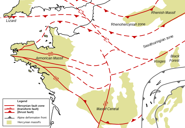
English: Structural geologic map of the north of France, showing Hercynian massifs and structures. Based on figures and information in the following literature:
|
| 日期 | |
| 来源 | 自己的作品 |
| 作者 | Woudloper |
| 其他版本 |
 |
许可协议[编辑]
| 我,本作品著作权人,释出本作品至公有领域。这适用于全世界。 在一些国家这可能不合法;如果是这样的话,那么: 我无条件地授予任何人以任何目的使用本作品的权利,除非这些条件是法律规定所必需的。 |
文件历史
点击某个日期/时间查看对应时刻的文件。
| 日期/时间 | 缩略图 | 大小 | 用户 | 备注 | |
|---|---|---|---|---|---|
| 当前 | 2008年11月27日 (四) 21:37 | | 850 × 590(274 KB) | Woudloper(留言 | 贡献) | {{Information |Description={{en|1=Structural geologic map of the north of France, showing Hercynian massifs and structures. Based on figures and information in the following literature: *{{aut|Service Géologique National}}; '''1996''': ''Carte géologiqu |
您不可以覆盖此文件。
文件用途
没有页面使用本文件。
全域文件用途
以下其他wiki使用此文件:
- en.wikipedia.org上的用途
- ja.wikipedia.org上的用途
- ro.wikipedia.org上的用途
- uk.wikipedia.org上的用途
- zh.wikipedia.org上的用途
分类:
- Variscan orogeny
- Geological maps of the Netherlands
- Geological maps of Belgium
- Geological maps of France
- Geological maps of Germany
- SVG geology
- Tectonics maps
- English-language SVG maps
- Geological maps of Switzerland
- Geological maps of England
- Geological maps of Luxembourg
- Armorican Massif
- Geology of the Massif Central