File:Friesland by Sentinel-2, 2018-06-30.jpg

Rozmiar pierwotny (12 535 × 9314 pikseli, rozmiar pliku: 130,04 MB, typ MIME: image/jpeg)
Podpisy
Podpisy
Opis[edytuj]
| Uwaga | Niektóre przeglądarki mogą mieć problem z wyświetlaniem tej grafiki w pełnej rozdzielczości. Ze względu na jej rozmiar obraz może nie być załadowany poprawnie lub spowodować zawieszenie się przeglądarki. |
|---|
| Opis |
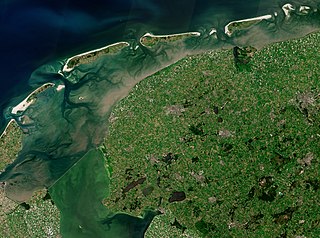
English: Date: 2018-06-30
Sensor: MSI on Sentinel-2A Resolution: 10m RGB Composites: True color, Band 4-3-2 |
| Data | |
| Źródło | https://scihub.copernicus.eu/dhus/#/home |
| Autor | Copernicus Sentinel-2, ESA |
| Inne wersje |
North Holland, Friesland and Flevoland
|
.jpg)
.jpg)
.jpg)


Licencja[edytuj]
- Wolno:
- dzielić się – kopiować, rozpowszechniać, odtwarzać i wykonywać utwór
- modyfikować – tworzyć utwory zależne
- Na następujących warunkach:
- uznanie autorstwa – musisz określić autorstwo utworu, podać link do licencji, a także wskazać czy utwór został zmieniony. Możesz to zrobić w każdy rozsądny sposób, o ile nie będzie to sugerować, że licencjodawca popiera Ciebie lub Twoje użycie utworu.
- na tych samych warunkach – Jeśli zmienia się lub przekształca niniejszy utwór, lub tworzy inny na jego podstawie, można rozpowszechniać powstały w ten sposób nowy utwór tylko na podstawie tej samej lub podobnej licencji.

|
This image contains data from a satellite in the Copernicus Programme, such as Sentinel-1, Sentinel-2 or Sentinel-3. Attribution is required when using this image.
Uznanie autorstwa: Contains modified Copernicus Sentinel data 2018
The use of Copernicus Sentinel Data is regulated under EU law (Commission Delegated Regulation (EU) No 1159/2013 and Regulation (EU) No 377/2014). Relevant excerpts:
Free access shall be given to GMES dedicated data [...] made available through GMES dissemination platforms [...].
Access to GMES dedicated data [...] shall be given for the purpose of the following use in so far as it is lawful:
GMES dedicated data [...] may be used worldwide without limitations in time.
GMES dedicated data and GMES service information are provided to users without any express or implied warranty, including as regards quality and suitability for any purpose. |
Historia pliku
Kliknij na odpowiedniej dacie/czasie, aby zobaczyć wersję pliku z tamtego okresu.
| Data/czas | Miniatura | Wymiary | Użytkownik | Opis | |
|---|---|---|---|---|---|
| aktualny | 15:47, 14 kwi 2020 | | 12 535 × 9314 (130,04 MB) | Satview (dyskusja | edycje) | Uploaded a work by Copernicus Sentinel-2, ESA from https://scihub.copernicus.eu/dhus/#/home with UploadWizard |
Nie możesz nadpisać tego pliku.
Lokalne wykorzystanie pliku
Następujące strony korzystają z tego pliku:
- Commons:WikiProject Aviation/recent uploads/2020 April 14
- File:Amsterdam with North Sea Canal by Sentinel-2, 2018-06-30.jpg
- File:Flevoland by Sentinel-2, 2018-06-30.jpg
- File:Flevopolder by Sentinel-2, 2018-06-30.jpg
- File:Noordoostpolder by Sentinel-2, 2018-06-30.jpg
- File:North Holland, Flevoland and parts of Friesland by Sentinel-2, 2018-06-30 (cropped to Drontermeer).jpg
- File:North Holland, Flevoland and parts of Friesland by Sentinel-2, 2018-06-30 (cropped to Eemmeer and Nijkerkernauw).jpg
- File:North Holland, Flevoland and parts of Friesland by Sentinel-2, 2018-06-30 (cropped to IJmeer).jpg
- File:North Holland, Flevoland and parts of Friesland by Sentinel-2, 2018-06-30 (cropped to Kadoelermeer and Vollenhovenmeer).jpg
- File:North Holland, Flevoland and parts of Friesland by Sentinel-2, 2018-06-30 (cropped to Ketelmeer and Ramsdiep).jpg
- File:North Holland, Flevoland and parts of Friesland by Sentinel-2, 2018-06-30 (cropped to Nuldernauw).jpg
- File:North Holland, Flevoland and parts of Friesland by Sentinel-2, 2018-06-30 (cropped to Vossemeer).jpg
- File:North Holland, Flevoland and parts of Friesland by Sentinel-2, 2018-06-30 (cropped to Wolderwijd).jpg
- File:North Holland, Flevoland and parts of Friesland by Sentinel-2, 2018-06-30 (cropped to Zwarte Meer).jpg
- File:North Holland, Flevoland and parts of Friesland by Sentinel-2, 2018-06-30 (small version).jpg
- File:North Holland, Friesland and Flevoland by Sentinel-2, 2018-06-30 (cropped to Almere Stad).jpg
- File:North Holland, Friesland and Flevoland by Sentinel-2, 2018-06-30 (cropped to Blauwe Meer).jpg
- File:North Holland, Friesland and Flevoland by Sentinel-2, 2018-06-30 (cropped to Veluwemeer).jpg
- File:North Holland, Friesland and Flevoland by Sentinel-2, 2018-06-30 (small version).jpg
- File:North Holland by Sentinel-2, 2018-06-30.jpg
.jpg)
.jpg)
.jpg)
.jpg)
.jpg)
.jpg)
.jpg)
.jpg)
.jpg)
.jpg)
.jpg)
.jpg)
Globalne wykorzystanie pliku
Ten plik jest wykorzystywany także w innych projektach wiki: